ملف:Goths4.PNG
Goths4.PNG (777 × 471 بكسل حجم الملف: 25 كيلوبايت، نوع MIME: image/png)
وصف قصير
| ⧼wm-license-information-description⧽ |
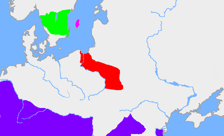
The red area is the extent of the en:Wielbark culture in the first half of the en:3rd century. The green area is the en:Götaland, and the pink area is the island of en:Gotland. The dark blue area is the en:Roman Empire (this map description was corrected on 10 April 2023; for reference see https://commons.wikimedia.org/wiki/File:Chernyakhov.PNG) My own map, based on en:User:Dbachmann's blank map. The extent of the Wielbark culture is based on Zbigniew Babik: "Najstarsza warstwa nazewnicza na ziemiach polskich" Cracow 2001. See also John Haywood, Cassell's Atlas of World History, Cassel Reference, 2001. pp. 1.21, 2.19. |
| ⧼wm-license-information-date⧽ | قالب:Original upload date |
| ⧼wm-license-information-source⧽ | قالب:Transferred from |
| ⧼wm-license-information-author⧽ | قالب:Original uploader |
ترخيص

|
قالب:Original upload log
قالب:Original description page
- 2005-04-14 16:22 Wiglaf 777×471×8 (25168 bytes)
تاريخ الملف
اضغط على زمن/تاريخ لرؤية الملف كما بدا في هذا الزمن.
| زمن/تاريخ | صورة مصغرة | الأبعاد | مستخدم | تعليق | |
|---|---|---|---|---|---|
| حالي | ★ مراجعة معتمدة 21:30، 18 ديسمبر 2023 | | 777 × 471 (25 كيلوبايت) | Pastakhov (نقاش | مساهمات) | Upload https://upload.wikimedia.org/wikipedia/commons/e/e5/Goths4.PNG |
لا يمكنك استبدال هذا الملف.
وصلات
لا يوجد صفحات تصل لهذه الصورة.