ملف:French Algeria evolution 1830-1962 map-es.svg

الملف الأصلي(ملف SVG، أبعاده 1٬373 × 1٬363 بكسل، حجم الملف: 1٫71 ميجابايت)

وصف قصير

⧼wm-license-information-description⧽
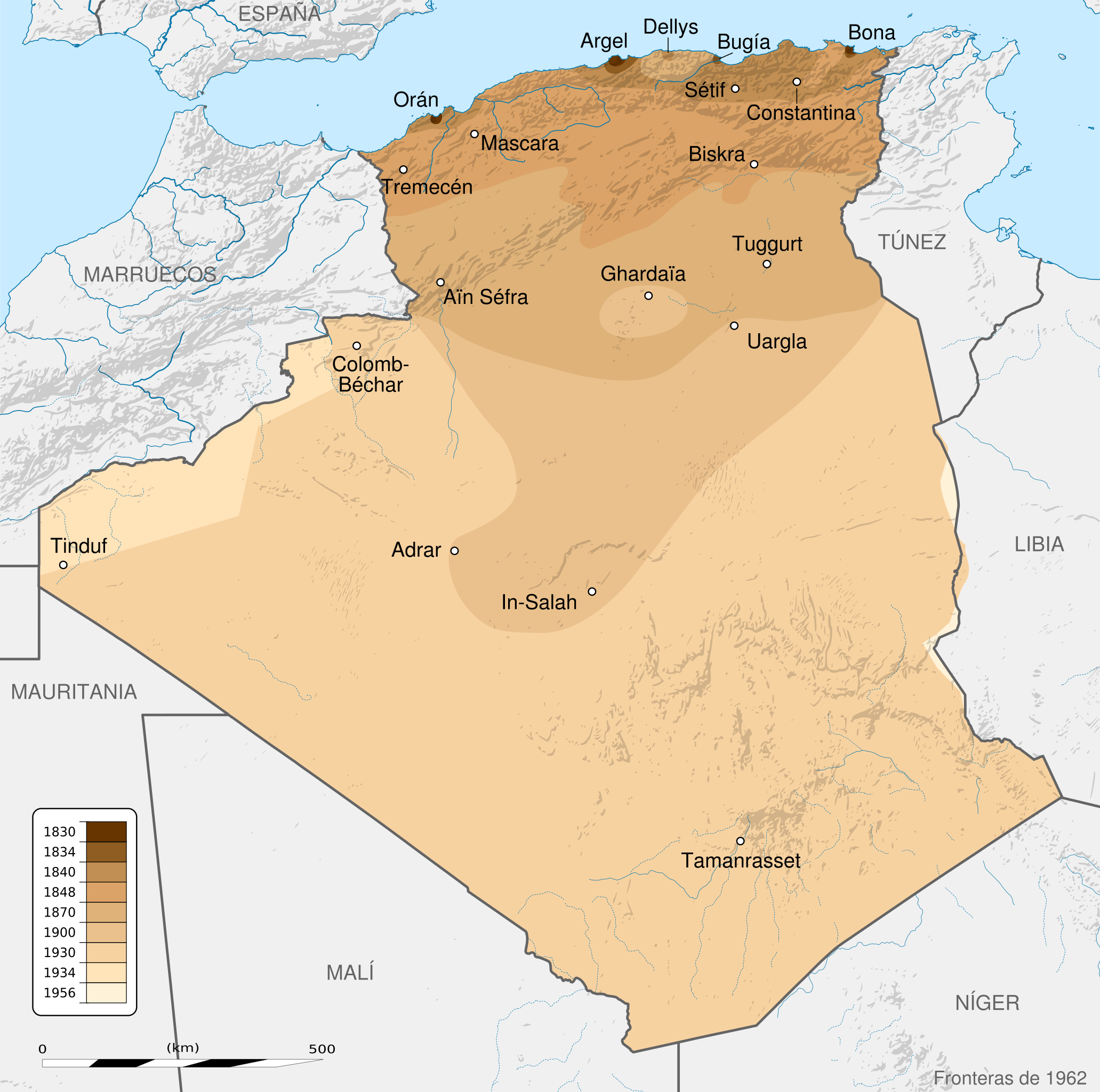
English: French Algeria evolution map, from 1830 to 1962.
  • Scale: 1:6,800,000 (precision: 1,700 m)
  • Equirectangular projection
  • WGS84 datum
  • Central meridian: 001° 39' E
  • Standard parallel: 27° 31' 30" N
  • Geographic limits of the map:
    • Top: 37° 48' N
    • Bottom: 18° 15' N
    • Left: 009° 27' W
    • Right: 012° 45' E
français: Carte montrant l'évolution territoriale de l'Algérie française, de 1830 à 1962.
  • Échelle : 1:6,800,000 (précision: 1,700 m)
  • Projection : équirectangulaire
  • Système géodésique : WGS84
  • Méridien de référence : 001° 39' E
  • Parallèle de référence : 27° 31' 30" N
  • Limites de la carte :
    • haut : 37° 48' N
    • bas : 18° 15' N
    • gauche : 009° 27' O
    • droite : 012° 45' E
  • ⧼wm-license-information-date⧽ 2012-09-29 18:09 (UTC)
    ⧼wm-license-information-source⧽ قالب:Derived from
    English:
    • Background: File:Algeria_location_map.svg
      • NGDC World Data Bank II (public domain)
      • NGDC GSHHS
    • Relief: NASA Shuttle Radar Topography Mission (SRTM3 v.2) (public domain)
    • Reference for the boundaries: SGIIAR (Système de Gestion Intégré de l'Information Agricole et Rurale of Algeria).
    • Evolution:
      • 1830-1930: File:Algérie 1830-1930.JPG
      • 1830-1857: Henri Blet (1946). Histoire de la colonisation française : Les étapes d'une renaissance coloniale, 1789-1870 (in الفرنسية). Vol. 2. Paris, France: Arthaud. pp. 136–137.
      • 1830-1930: Xavier Yacono (1993). Histoire de l'Algérie de la fin de la Régence turque à l'insurrection de 1954 (in الفرنسية). Paris, France: Éditions de l'Atlanthrope. p. 262. ISBN 2-86442-032-6. {{cite book}}: Check |isbn= value: checksum (help)
      • 1830-1930: Commandant P. Pollacchi (1930). Les progrès de la pacification française (in الفرنسية). Collection du Comité Métropolitain du Centenaire de l'Algérie.
      • 1956: File:Algeria-Libya boundary.jpg
    français:
  • Fond de carte : File:Algeria_location_map.svg
    • NGDC World Data Bank II (domaine public)
    • NGDC GSHHS
  • Relief : NASA Shuttle Radar Topography Mission (SRTM3 v.2) (domaine public)
  • Référence pour les frontières : SGIIAR (Système de Gestion Intégré de l'Information Agricole et Rurale d'Algérie).
  • Évolution:
    • 1830-1930: File:Algérie 1830-1930.JPG
    • 1830-1857: Henri Blet (1946). Histoire de la colonisation française : Les étapes d'une renaissance coloniale, 1789-1870 (in الفرنسية). Vol. 2. Paris, France: Arthaud. pp. 136–137.
    • 1830-1930: Xavier Yacono (1993). Histoire de l'Algérie de la fin de la Régence turque à l'insurrection de 1954 (in الفرنسية). Paris, France: Éditions de l'Atlanthrope. p. 262. ISBN 2-86442-032-6. {{cite book}}: Check |isbn= value: checksum (help)
    • 1830-1930: Commandant P. Pollacchi (1930). Les progrès de la pacification française (in الفرنسية). Collection du Comité Métropolitain du Centenaire de l'Algérie.
    • 1956: File:Algeria-Libya boundary.jpg
  • ⧼wm-license-information-author⧽ Sémhur
    ⧼wm-license-information-other-versions⧽

    قالب:DerivativeVersions

    ⧼wm-license-cc-attribution⧽
    (قالب:I18n/Credit line)
    © Sémhur / Wikimedia CommonsCC-BY-SA-3.0 (or Free Art License)

    قالب:Location dec


    Applications-graphics.svg [This is a retouched picture, which means that it has been digitally altered from its original version. Modifications: translated into Spanish. The original can be viewed here: French_Algeria_evolution_1830-1962_map-fr.svg. Modifications made by rowanwindwhistler.] Error: {{Lang}}: text has italic markup (help)

    Azərbaycanca | Беларуская (тарашкевіца) | বাংলা | Català | Čeština | Dansk | Deutsch | Zazaki | English | Esperanto | Español | Eesti | فارسی | Suomi | Français | Galego | Hrvatski | Magyar | Հայերեն | Italiano | 日本語 | Ქართული | ភាសាខ្មែរ | 한국어 | Kurdî | Македонски | മലയാളം | Bahasa Melayu | Plattdüütsch | Nederlands | Polski | Português | Română | Русский | Slovenščina | Српски / srpski | Svenska | Türkçe | Українська | Vèneto | 中文 | 中文(简体) | 中文(繁體) | 中文(臺灣) | +/−

    قالب:ValidSVG

    قالب:Translation possible قالب:Atelier graphique carte

    ترخيص


    I, the copyright holder of this work, hereby publish it under the following licenses:
    قالب:FAL قالب:Cc-by-sa-all
    [You may select the license of your choice.] Error: {{Lang}}: text has italic markup (help)

    قالب:Original upload log

    This image is a derivative work of the following images:

    • File:Algeria_location_map.svg licensed with Cc-by-sa-3.0, GFDL
      • 2009-11-17T12:51:26Z Sting 1287x1278 (372657 Bytes) == {{int:filedesc}} == {{Location|28|19|00|N|1|39|00|E|scale:8000000}} {{Information |Description={{en|Blank administrative map of [[:en:Algeria|Algeria]], for geo-location purposes.}} {{fr|Carte administrative vierge de l'[
    • File:French_Algeria_evolution_1830-1962_map-fr.svg licensed with Cc-by-sa-3.0,2.5,2.0,1.0, FAL
      • 2012-09-29T18:57:51Z Sémhur 1287x1278 (1949143 Bytes) == {{int:filedesc}} == {{Information |Description={{Multilingual description |en= [[:en:French Algeria|]] evolution map, from 1830 to 1962. |fr= Carte de l'[[:fr:Algérie française|]], de 1830 à 1962. }} Scale: 1:6,800,00

    قالب:Uploaded with derivativeFX

    تاريخ الملف

    اضغط على زمن/تاريخ لرؤية الملف كما بدا في هذا الزمن.

    زمن/تاريخصورة مصغرةالأبعادمستخدمتعليق
    حالي ★ مراجعة معتمدة
    22:42، 10 أكتوبر 2023
    تصغير للنسخة بتاريخ 22:42، 10 أكتوبر 20231٬373 × 1٬363 (1٫71 ميجابايت)Pastakhov (نقاش | مساهمات)Upload https://upload.wikimedia.org/wikipedia/commons/b/bb/French_Algeria_evolution_1830-1962_map-es.svg

    لا يوجد صفحات تصل لهذه الصورة.

    معلومات الصورة (ميتا)