ملف:Fiat Lux Canticle map.png

حجم هذه المعاينة: 800 × 571 بكسل. البعد الآخر: 850 × 607 بكسل.
الملف الأصلي (850 × 607 بكسل حجم الملف: 848 كيلوبايت، نوع MIME: image/png)
| ⧼wm-license-information-description⧽ |
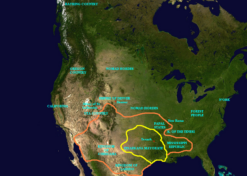
English: A map of North America in Walter M. Miller's A Canticle for Leibowitz. Specifically, the map depicts the territorial arrangement in 3174, during the time frame of "Fiat Lux". Texark territory outlined in yellow; Texark expansion as described in "Fiat Lux" and in Saint Leibowitz and the Wild Horse Woman marked in orange.
|
| ⧼wm-license-information-date⧽ | |
| ⧼wm-license-information-source⧽ | User created |
| ⧼wm-license-information-author⧽ | User:Briangotts |
| ⧼wm-license-information-permission⧽ (⧼wm-license-information-permission-reusing-text⧽) |
تاريخ الملف
اضغط على زمن/تاريخ لرؤية الملف كما بدا في هذا الزمن.
| زمن/تاريخ | صورة مصغرة | الأبعاد | مستخدم | تعليق | |
|---|---|---|---|---|---|
| حالي | ★ مراجعة معتمدة 02:53، 20 يناير 2024 | | 850 × 607 (848 كيلوبايت) | Pastakhov (نقاش | مساهمات) | Upload https://upload.wikimedia.org/wikipedia/commons/e/e3/Fiat_Lux_Canticle_map.png |
لا يمكنك استبدال هذا الملف.
وصلات
لا يوجد صفحات تصل لهذه الصورة.