ملف:Estado de Quito (1810-1812).jpg
لا توجد دقة أعلى متوفرة.
Estado_de_Quito_(1810-1812).jpg (617 × 454 بكسل حجم الملف: 500 كيلوبايت، نوع MIME: image/jpeg)
وصف قصير
| ⧼wm-license-information-description⧽ |
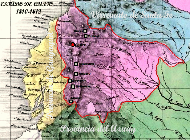
Español: Mapa del Estado de Quito, entre 1810 y 1812. Se resaltan las ocho ciudades que enviaron representantes al Congreso Supremo instalado en la ciudad de Quito el 11 de octubre de 1811 por orden del coronel Carlos de Montúfar, mismas que pasaron a convertirse en provincias del nuevo Estado de Quito, cuya constitución se publicó el 15 de febrero de 1812; a saber: Alausí, Ambato, Guaranda, Ibarra, Latacunga, Otavalo, Quito y Riobamba.
|
| ⧼wm-license-information-date⧽ | 2013, {{time}} – invalid date format 52 (help) |
| ⧼wm-license-information-source⧽ | ⧼Wm-license-own-work⧽ |
| ⧼wm-license-information-author⧽ | H3kt0r |
ترخيص
|
تاريخ الملف
اضغط على زمن/تاريخ لرؤية الملف كما بدا في هذا الزمن.
| زمن/تاريخ | صورة مصغرة | الأبعاد | مستخدم | تعليق | |
|---|---|---|---|---|---|
| حالي | ★ مراجعة معتمدة 18:14، 19 أكتوبر 2023 | | 617 × 454 (500 كيلوبايت) | Pastakhov (نقاش | مساهمات) | Upload https://upload.wikimedia.org/wikipedia/commons/c/ce/Estado_de_Quito_%281810-1812%29.jpg |
لا يمكنك استبدال هذا الملف.
وصلات
لا يوجد صفحات تصل لهذه الصورة.
.jpg&oldid=3182171)