ملف:Electorate of Saxony 1789.svg

حجم معاينة PNG لذلك الملف ذي الامتداد SVG: 450 × 456 بكسل. البعد الآخر: 2٬021 × 2٬048 بكسل.
الملف الأصلي (ملف SVG، أبعاده 450 × 456 بكسل، حجم الملف: 928 كيلوبايت)
وصف قصير
| ⧼wm-license-information-description⧽ |
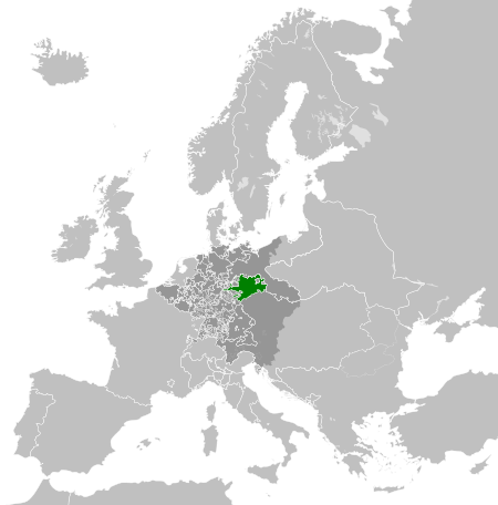
English: A map of the Electorate of Saxony circa 1789. Deutsch: Eine Landkarte das Kurfürstentum Sachsen c. 1789.
|
| ⧼wm-license-information-date⧽ | 2013-04-14 15:58 (UTC) |
| ⧼wm-license-information-source⧽ | قالب:Derived from |
| ⧼wm-license-information-author⧽ |
|
| ⧼wm-license-information-other-versions⧽ |
ترخيص
|
قالب:Original upload log
This image is a derivative work of the following images:
- File:Europe_1789.svg licensed with Cc-by-sa-3.0
- 2013-04-14T03:44:26Z Alphathon 450x456 (858577 Bytes) Corrected some errors in northern Italy
- 2013-04-14T01:38:01Z Alphathon 450x456 (853881 Bytes) tweaked again
- 2013-04-14T01:36:10Z Alphathon 450x456 (853881 Bytes) Tweaked Holy Roman Empire border style
- 2013-04-14T01:33:26Z Alphathon 450x456 (853857 Bytes) == {{int:filedesc}} == {{Information |Description={{en|A blank Map of Europe circa 1789. This map also includes a border for the [[:en:Holy Roman Empire|Holy Roman Empire]]. Since there are so many small German states, they h
تاريخ الملف
اضغط على زمن/تاريخ لرؤية الملف كما بدا في هذا الزمن.
| زمن/تاريخ | صورة مصغرة | الأبعاد | مستخدم | تعليق | |
|---|---|---|---|---|---|
| حالي | ★ مراجعة معتمدة 04:25، 2 ديسمبر 2023 | | 450 × 456 (928 كيلوبايت) | Pastakhov (نقاش | مساهمات) | Upload https://upload.wikimedia.org/wikipedia/commons/2/26/Electorate_of_Saxony_1789.svg |
لا يمكنك استبدال هذا الملف.
وصلات
لا يوجد صفحات تصل لهذه الصورة.