ملف:Easter Island map-fr.svg

حجم معاينة PNG لذلك الملف ذي الامتداد SVG: 800 × 569 بكسل. البعد الآخر: 2٬560 × 1٬821 بكسل.
الملف الأصلي (ملف SVG، أبعاده 1٬750 × 1٬245 بكسل، حجم الملف: 878 كيلوبايت)
وصف قصير
| خطأ في التعبير: عامل < غير متوقع. English: {{Potd/{{{year}}}-{{{month}}}-{{{day}}} (en) }} ⧼Tpt-languages-legend⧽ |
| ⧼wm-license-information-description⧽ |
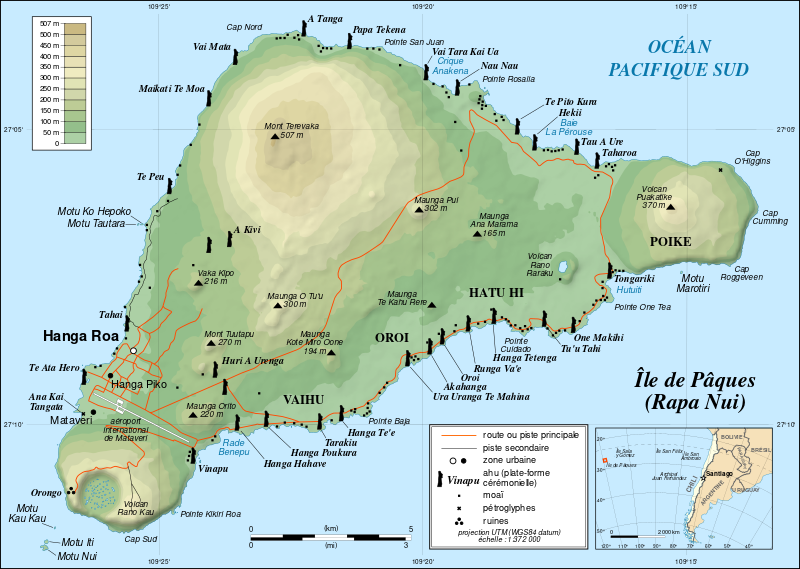
English: Topographic map in French of Easter Island.
Note: The shaded relief is a raster image embedded in the SVG file. Français : Carte topographique en français de l'île de Pâques. Note : les ombres du relief sont une image bitmap embarquée dans le fichier SVG.
|
| ⧼wm-license-information-date⧽ | November 2006 - October 2008 for the new version (see the release note) |
| ⧼wm-license-information-source⧽ | Own work
|
| ⧼wm-license-information-author⧽ | Eric Gaba (Sting - fr:Sting) |
| ⧼wm-license-information-permission⧽ (⧼wm-license-information-permission-reusing-text⧽) |
|
| ⧼wm-license-information-other-versions⧽ |
![[1]](http://www.waymarker.co.uk/ml/rapanui/map.jpg)
|
|
This image was created with Inkscape. |
ترخيص
تاريخ الملف
اضغط على زمن/تاريخ لرؤية الملف كما بدا في هذا الزمن.
| زمن/تاريخ | صورة مصغرة | الأبعاد | مستخدم | تعليق | |
|---|---|---|---|---|---|
| حالي | ★ مراجعة معتمدة 08:46، 1 ديسمبر 2023 | | 1٬750 × 1٬245 (878 كيلوبايت) | Pastakhov (نقاش | مساهمات) | Upload https://upload.wikimedia.org/wikipedia/commons/e/e7/Easter_Island_map-fr.svg |
لا يمكنك استبدال هذا الملف.
وصلات
لا يوجد صفحات تصل لهذه الصورة.