ملف:East Charleton - geograph.org.uk - 843865.jpg
حجم هذه المعاينة: 450 × 600 بكسل. البعد الآخر: 480 × 640 بكسل.
الملف الأصلي (480 × 640 بكسل حجم الملف: 90 كيلوبايت، نوع MIME: image/jpeg)
وصف قصير
| ⧼wm-license-information-description⧽ |
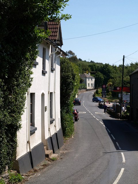
English: East Charleton The A379 sweeps through the heart of this small village; few motorists seem to adhere to the 20 mph speed limit. The cottage on the left seems to be making a determined effort to shrink back from the carriageway. On the right is the village's (and the wider neighbourhood's) superstore - a large shop and petrol station.
|
| ⧼wm-license-information-date⧽ | 2008 |
| ⧼wm-license-information-source⧽ | From geograph.org.uk |
| ⧼wm-license-information-author⧽ | Derek Harper |
| ⧼wm-license-cc-attribution⧽ (قالب:I18n/Credit line) |
Derek Harper / East Charleton / |
50°16′14″N 3°44′20″W / 50.27058°N 3.7388°W قالب:Object location
_heading:67)
ترخيص
تاريخ الملف
اضغط على زمن/تاريخ لرؤية الملف كما بدا في هذا الزمن.
| زمن/تاريخ | صورة مصغرة | الأبعاد | مستخدم | تعليق | |
|---|---|---|---|---|---|
| حالي | ★ مراجعة معتمدة 11:50، 29 أكتوبر 2023 | | 480 × 640 (90 كيلوبايت) | Pastakhov (نقاش | مساهمات) | Upload https://upload.wikimedia.org/wikipedia/commons/5/52/East_Charleton_-_geograph.org.uk_-_843865.jpg |
لا يمكنك استبدال هذا الملف.
وصلات
لا يوجد صفحات تصل لهذه الصورة.