ملف:EO1 ALI Lamay Island.jpg
لا توجد دقة أعلى متوفرة.
EO1_ALI_Lamay_Island.jpg (530 × 455 بكسل حجم الملف: 227 كيلوبايت، نوع MIME: image/jpeg)
| ⧼wm-license-information-description⧽ |
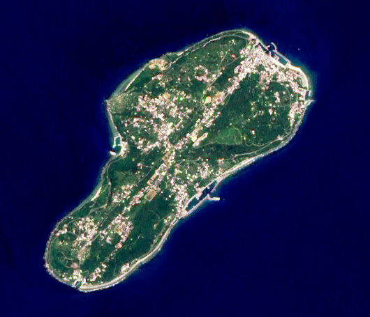
English: The Advanced Land Imager (ALI) on NASA’s Earth Observing-1 satellite captured this image of Lamay Island offshore southwestern Taiwan. This 10-meter resolution false-colored image shows the old airstrip has been occupied by the buildings on the island.
صينية: 2003年夏天NASA EO-1衛星所拍攝到的琉球嶼, 影像解析度為10公尺。 |
||
| ⧼wm-license-information-date⧽ | 2003 | ||
| ⧼wm-license-information-source⧽ | Data source from Earth Observing 1 (EO-1) satellite. Image processed by myself | ||
| ⧼wm-license-information-author⧽ | Macos8 | ||
| ⧼wm-license-information-permission⧽ (⧼wm-license-information-permission-reusing-text⧽) |
|
تاريخ الملف
اضغط على زمن/تاريخ لرؤية الملف كما بدا في هذا الزمن.
| زمن/تاريخ | صورة مصغرة | الأبعاد | مستخدم | تعليق | |
|---|---|---|---|---|---|
| حالي | ★ مراجعة معتمدة 19:31، 30 أكتوبر 2023 | | 530 × 455 (227 كيلوبايت) | Pastakhov (نقاش | مساهمات) | Upload https://upload.wikimedia.org/wikipedia/commons/2/2c/EO1_ALI_Lamay_Island.jpg |
لا يمكنك استبدال هذا الملف.
وصلات
لا يوجد صفحات تصل لهذه الصورة.