ملف:Druhá Československá republika 1938.png
حجم هذه المعاينة: 800 × 370 بكسل. البعد الآخر: 2٬300 × 1٬064 بكسل.
الملف الأصلي (2٬300 × 1٬064 بكسل حجم الملف: 455 كيلوبايت، نوع MIME: image/png)
وصف قصير
| ⧼wm-license-information-description⧽ |
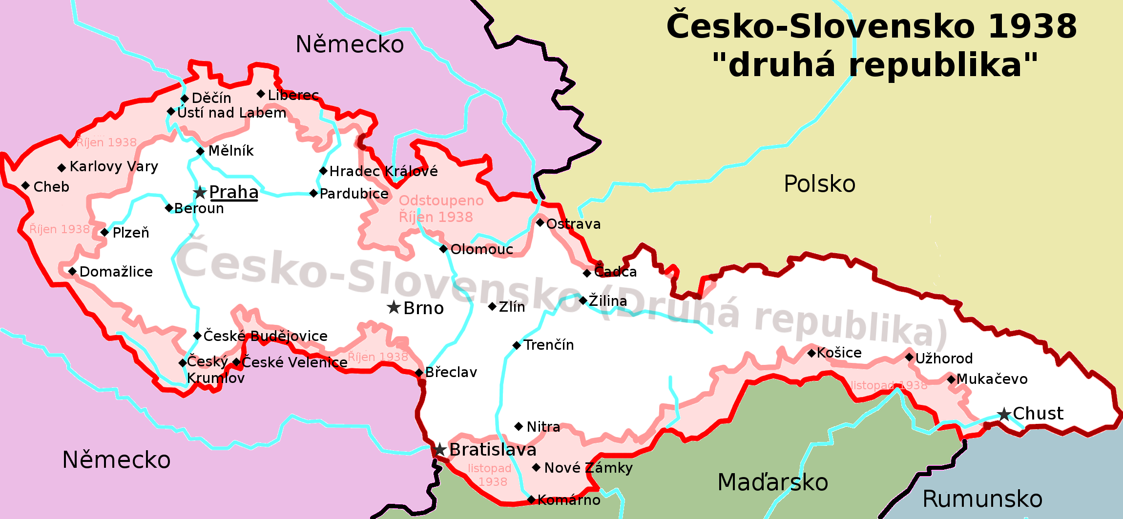
(بالتشيكية) English: Czechoslovak republic in the end of 1938 after territorial losses caused by Munich agreement and other agreements with neighboring countries.
Boundaries
Territory
Towns and cities
|
| ⧼wm-license-information-date⧽ | 09. 01. 2009 |
| ⧼wm-license-information-source⧽ | ⧼Wm-license-own-work⧽ |
| ⧼wm-license-information-author⧽ | Aktron |
| ⧼wm-license-information-permission⧽ (⧼wm-license-information-permission-reusing-text⧽) |
viz licence - see licence |
| ⧼wm-license-information-other-versions⧽ |
قالب:DerivativeVersions viz kategorie - see category |
ترخيص
|

تاريخ الملف
اضغط على زمن/تاريخ لرؤية الملف كما بدا في هذا الزمن.
| زمن/تاريخ | صورة مصغرة | الأبعاد | مستخدم | تعليق | |
|---|---|---|---|---|---|
| حالي | ★ مراجعة معتمدة 11:01، 11 أكتوبر 2023 | | 2٬300 × 1٬064 (455 كيلوبايت) | Pastakhov (نقاش | مساهمات) | Upload https://upload.wikimedia.org/wikipedia/commons/8/81/Druh%C3%A1_%C4%8Ceskoslovensk%C3%A1_republika_1938.png |
لا يمكنك استبدال هذا الملف.
وصلات
لا يوجد صفحات تصل لهذه الصورة.
معلومات الصورة (ميتا)
تصنيفات:
- صفحات بوصلات خارجية بالتشيكية
- Self-published work
- Maps of the Second Polish Republic
- Maps of the history of Slovakia
- Maps of Nazi Germany
- Location not applicable
- Maps of the history of Hungary between the World Wars
- Maps of the Czechoslovak Republic (1938–1939)
- Czechoslovakia-Poland border
- First Vienna Award