ملف:Districts of the Western Region (2012).svg

حجم معاينة PNG لذلك الملف ذي الامتداد SVG: 422 × 599 بكسل. البعد الآخر: 1٬442 × 2٬048 بكسل.
الملف الأصلي (ملف SVG، أبعاده 524 × 744 بكسل، حجم الملف: 2٫68 ميجابايت)
وصف قصير
قالب:Igen
| ⧼wm-license-information-description⧽ |
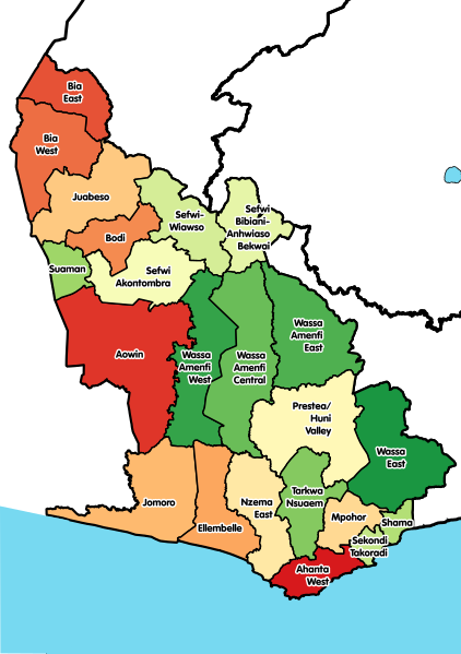
English: Map showing all 22 districts of the Western Region of Ghana, including the new districts that were created in 2012.
|
| ⧼wm-license-information-date⧽ | 2017 |
| ⧼wm-license-information-source⧽ | ⧼Wm-license-own-work⧽ |
| ⧼wm-license-information-author⧽ | Macabe5387 |
ترخيص
|
تاريخ الملف
اضغط على زمن/تاريخ لرؤية الملف كما بدا في هذا الزمن.
| زمن/تاريخ | صورة مصغرة | الأبعاد | مستخدم | تعليق | |
|---|---|---|---|---|---|
| حالي | ★ مراجعة معتمدة 02:49، 8 ديسمبر 2023 | | 524 × 744 (2٫68 ميجابايت) | Pastakhov (نقاش | مساهمات) | Upload https://upload.wikimedia.org/wikipedia/commons/a/a0/Districts_of_the_Western_Region_%282012%29.svg |
لا يمكنك استبدال هذا الملف.
وصلات
لا يوجد صفحات تصل لهذه الصورة.
.svg&oldid=3721882)