ملف:Daraawiish state 1900s, Dervish state 1900s.png
الملف الأصلي (5٬624 × 3٬544 بكسل حجم الملف: 631 كيلوبايت، نوع MIME: image/png)
وصف قصير
| ⧼wm-license-information-description⧽ |
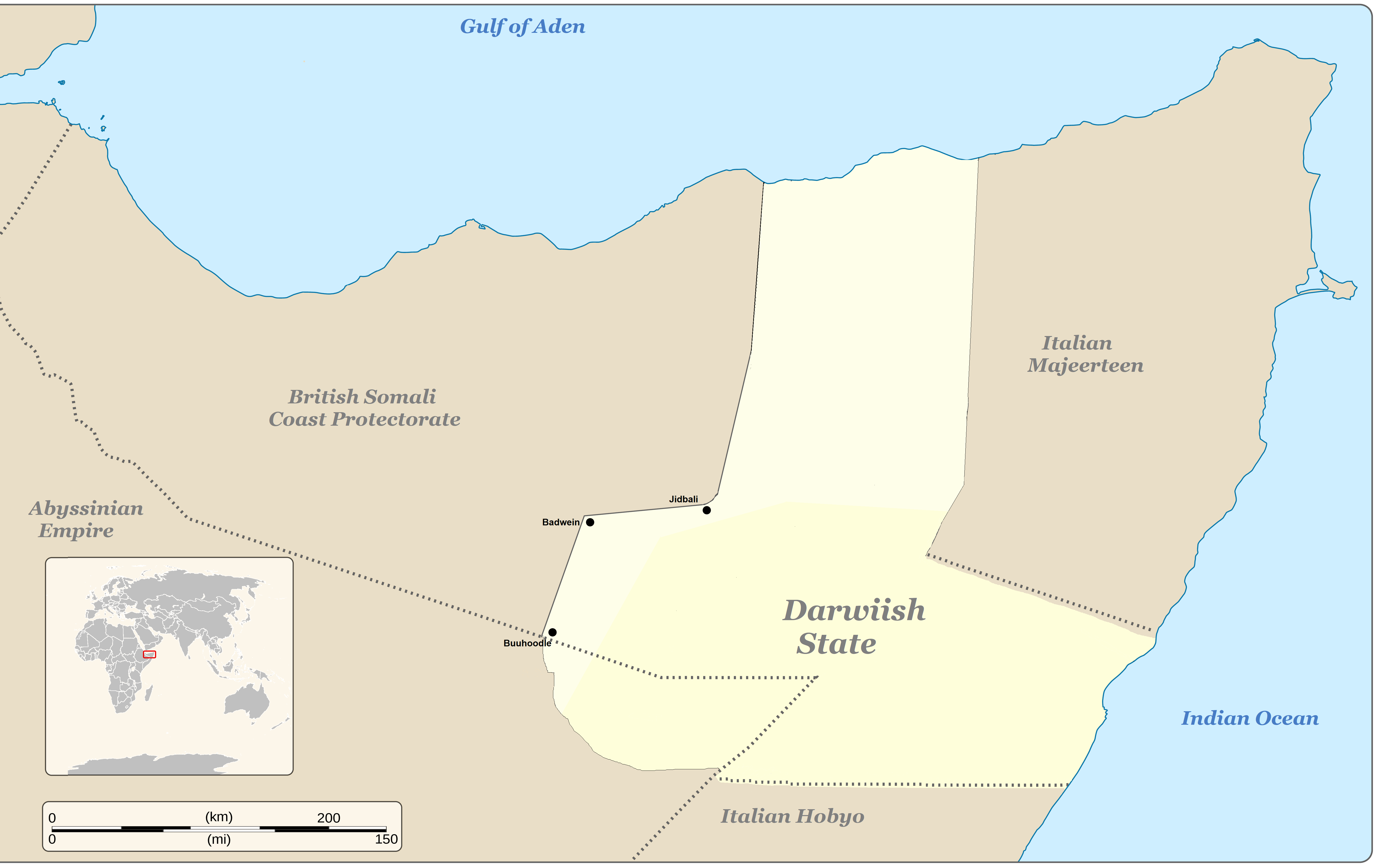
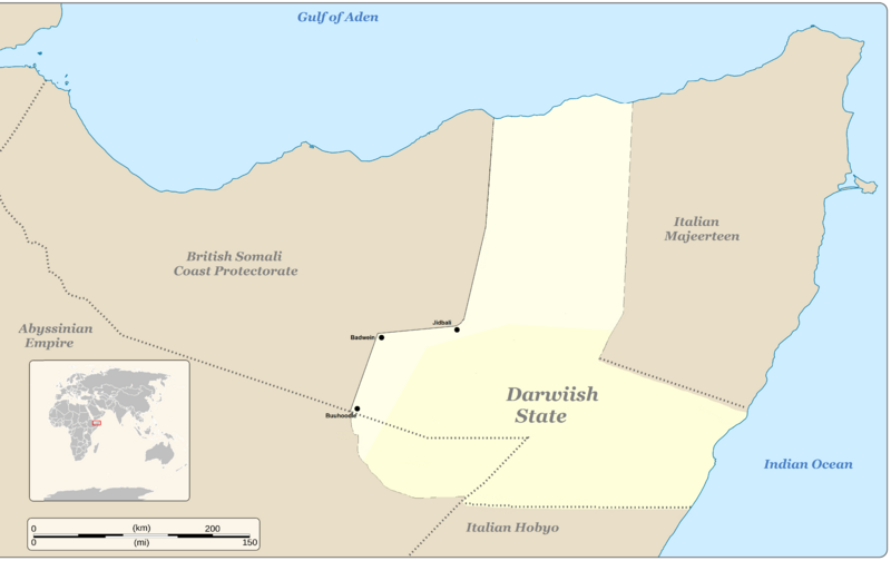
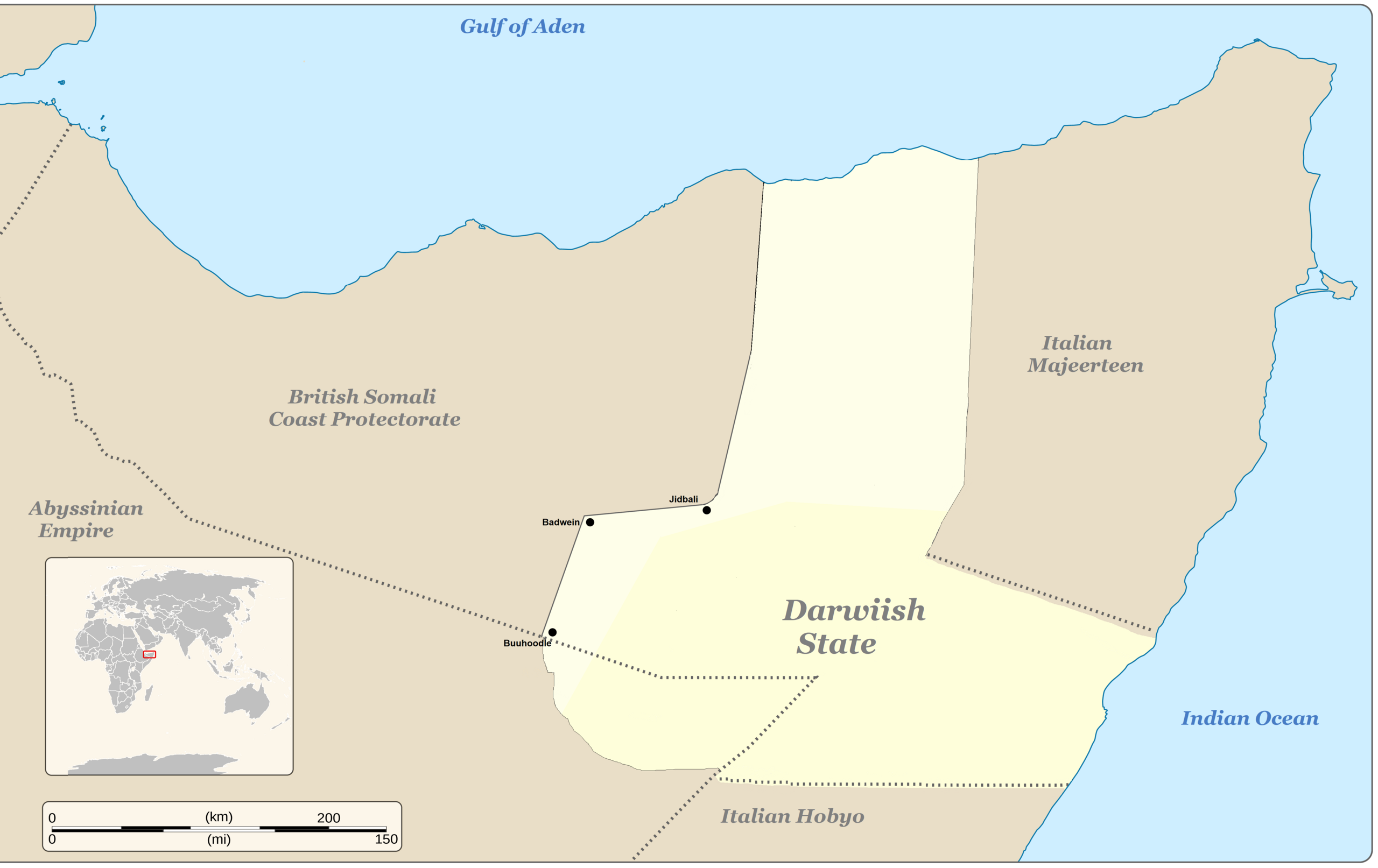
English: Daraawiish state in the 1900s decade; Dervish state in the 1900s decade, from 1904 until 15 March 1910
|
| ⧼wm-license-information-date⧽ | 2022 |
| ⧼wm-license-information-source⧽ | ⧼Wm-license-own-work⧽ The base image used for the eastern borders was the "Ibraahim Muxamed" image sourced from page 76 of Taariikhda Soomaaliya depicted besides "Other Versions" below. Ibraahim Muxamed's borders are based upon the 1904 Illig treaty borders, which in this file is juxtaposed upon the proclaimed western Dervish borders. Information for the western border is derived from the 1908 Dervish proclaimed border as stated in page 151 in Taariikhdii daraawiishta iyo Sayid Maxamed Cabdulle Xasan, Jaamac Cumar Ciise, 1976. The page depicts Buuhoodle, Badwein, Jidbali and the Warsangeli-Isaaq border as Dervish proclaimed territory, particularly in the following excerpt: "remove your party from Bohotle and also remove the horses from Badwein ... call back your spies from Jidbali, ... let me settle between the Isak and the Warsangeli" (accessible link) The bottom shading (light/dark) represents the Halin, Hudin (Hudun), Tifafleh, and Danot (also called Docmo & Damot), borders from the Illig treaty circa 1904, shadings representing chronological progression, per page 90, of Roy Irons 2013 book "Betrayal and Redemption":
|
| ⧼wm-license-information-author⧽ | Herddonnwastetime |
| ⧼wm-license-information-other-versions⧽ |
ترخيص
تاريخ الملف
اضغط على زمن/تاريخ لرؤية الملف كما بدا في هذا الزمن.
| زمن/تاريخ | صورة مصغرة | الأبعاد | مستخدم | تعليق | |
|---|---|---|---|---|---|
| حالي | ★ مراجعة معتمدة 18:57، 24 أكتوبر 2023 | | 5٬624 × 3٬544 (631 كيلوبايت) | Pastakhov (نقاش | مساهمات) | Upload https://upload.wikimedia.org/wikipedia/commons/9/96/Daraawiish_state_1900s%2C_Dervish_state_1900s.png |
لا يمكنك استبدال هذا الملف.
وصلات
لا يوجد صفحات تصل لهذه الصورة.