ملف:Crossrail construction site, Farringdon - geograph.org.uk - 2259281.jpg
لا توجد دقة أعلى متوفرة.
Crossrail_construction_site,_Farringdon_-_geograph.org.uk_-_2259281.jpg (640 × 480 بكسل حجم الملف: 133 كيلوبايت، نوع MIME: image/jpeg)
وصف قصير
| ⧼wm-license-information-description⧽ |
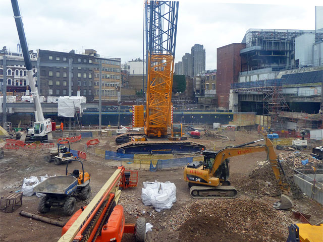
English: Crossrail construction site, Farringdon, near to London, City of London, Great Britain.
Centrally is a massive crawler crane. This area is associated with the western ticket hall which will be part of the station. There will be passenger interchange with the existing sub-surface lines here. The Underground lines here using the northern part of the Circle Line pass east beyond what looks like two portals (but aren't) just visible between the crane and the rust-coloured building. The Thameslink line to south of the river veers south under the girder to the right of this building. Taken through a grubby and not too transparent plastic viewing port - the hoarding is too high to reach above.
|
| ⧼wm-license-information-date⧽ | 2011 |
| ⧼wm-license-information-source⧽ | From geograph.org.uk; transferred by User:Adambro using geograph_org2commons. |
| ⧼wm-license-information-author⧽ | Robin Webster |
| ⧼wm-license-information-permission⧽ (⧼wm-license-information-permission-reusing-text⧽) |
Creative Commons Attribution Share-alike license 2.0 |
| ⧼wm-license-cc-attribution⧽ (قالب:I18n/Credit line) |
Robin Webster / Crossrail construction site, Farringdon / |
قالب:Location dec قالب:Object location
ترخيص
تاريخ الملف
اضغط على زمن/تاريخ لرؤية الملف كما بدا في هذا الزمن.
| زمن/تاريخ | صورة مصغرة | الأبعاد | مستخدم | تعليق | |
|---|---|---|---|---|---|
| حالي | ★ مراجعة معتمدة 11:23، 14 أكتوبر 2023 | | 640 × 480 (133 كيلوبايت) | Pastakhov (نقاش | مساهمات) | Upload https://upload.wikimedia.org/wikipedia/commons/9/96/Crossrail_construction_site%2C_Farringdon_-_geograph.org.uk_-_2259281.jpg |
لا يمكنك استبدال هذا الملف.
وصلات
لا يوجد صفحات تصل لهذه الصورة.