ملف:Connecticut US Congressional District 3 (since 2013).tif

حجم معاينة PNG لذلك الملف ذي الامتداد TIF: 800 × 381 بكسل.
الملف الأصلي (2٬116 × 1٬008 بكسل حجم الملف: 3٫47 ميجابايت، نوع MIME: image/tiff)
وصف قصير
| ⧼wm-license-information-description⧽ |
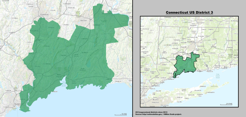
English: Boundaries for Connecticut’s 3rd United States Federal Congressional District.
|
| ⧼wm-license-information-date⧽ | 2014, {{time}} – invalid date format 13 (help) |
| ⧼wm-license-information-source⧽ | GIS shapefile data created by the United States Department of the Interior, as part of the "1 Million Scale" geospatial data project. Retrieved from: http://nationalatlas.gov/atlasftp-1m.html?openChapters=#chpbound |
| ⧼wm-license-information-author⧽ | 1: GIS (congressional districts, 2013) shapefile data was created by the United States Department of the Interior. 2: Data was rendered using ArcGIS® software by Esri. 3: File developed for use on Wikipedia and elsewhere by 7partparadigm. |
ترخيص
تاريخ الملف
اضغط على زمن/تاريخ لرؤية الملف كما بدا في هذا الزمن.
| زمن/تاريخ | صورة مصغرة | الأبعاد | مستخدم | تعليق | |
|---|---|---|---|---|---|
| حالي | ★ مراجعة معتمدة 07:32، 7 ديسمبر 2023 |  | 2٬116 × 1٬008 (3٫47 ميجابايت) | Pastakhov (نقاش | مساهمات) | Upload https://upload.wikimedia.org/wikipedia/commons/e/ea/Connecticut_US_Congressional_District_3_%28since_2013%29.tif |
لا يمكنك استبدال هذا الملف.
وصلات
لا يوجد صفحات تصل لهذه الصورة.