ملف:City Lights of the United States 2012.jpg

الملف الأصلي (6٬646 × 4٬430 بكسل حجم الملف: 5٫46 ميجابايت، نوع MIME: image/jpeg)
وصف قصير
| ⧼wm-license-information-description⧽ |
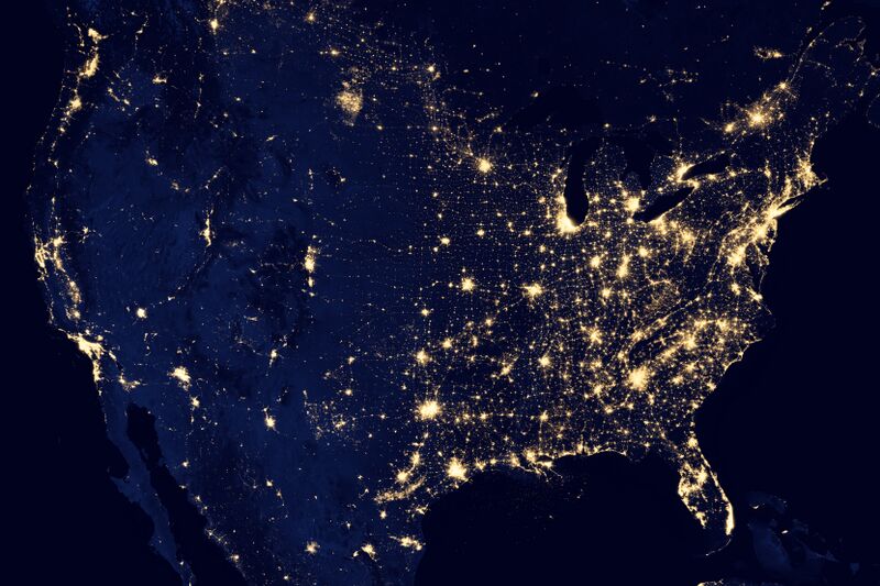
English: NASA image acquired April 18 - October 23, 2012
This image of the United States of America at night is a composite assembled from data acquired by the Suomi NPP satellite in April and October 2012. The image was made possible by the new satellite’s “day-night band” of the Visible Infrared Imaging Radiometer Suite (VIIRS), which detects light in a range of wavelengths from green to near-infrared and uses filtering techniques to observe dim signals such as city lights, gas flares, auroras, wildfires, and reflected moonlight. Instrument: Suomi NPP - VIIRS Projection: Albers equal-area conic, WGS84 datum, standard parallels 29.5°N and 44.5°N, central meridian 96°W, origin latitude 23°N On this image one pixel is (737.19 × 737.19)m² |
| ⧼wm-license-information-date⧽ | 2012 |
| ⧼wm-license-information-source⧽ | http://earthobservatory.nasa.gov/NaturalHazards/view.php?id=79800 for GeoTIFF original file. https://www.flickr.com/photos/gsfc/8247975848/in/set-72157632172101342/ for quicker access to the jpeg |
| ⧼wm-license-information-author⧽ | NASA Earth Observatory |
| ⧼wm-license-information-other-versions⧽ |
|
ترخيص
تاريخ الملف
اضغط على زمن/تاريخ لرؤية الملف كما بدا في هذا الزمن.
| زمن/تاريخ | صورة مصغرة | الأبعاد | مستخدم | تعليق | |
|---|---|---|---|---|---|
| حالي | ★ مراجعة معتمدة 14:49، 23 أكتوبر 2023 | | 6٬646 × 4٬430 (5٫46 ميجابايت) | Pastakhov (نقاش | مساهمات) | Upload https://upload.wikimedia.org/wikipedia/commons/1/18/City_Lights_of_the_United_States_2012.jpg |
لا يمكنك استبدال هذا الملف.
وصلات
لا يوجد صفحات تصل لهذه الصورة.
معلومات الصورة (ميتا)
- Assessment tagged pages that are not in the file namespace
- Broken FPC links
- صور ناسا
- Featured pictures of the United States
- Photos of North America by VIIRS
- Maps of the United States
- Night in the United States
- 2012 maps of the United States
- Maps made in the 21st century
- Maps with Albers projection
- Language-neutral maps
- Featured pictures from NASA
- Files from NASA Goddard Space Flight Center Flickr stream
- Featured pictures of Earth from space