ملف:Chola map.png
لا توجد دقة أعلى متوفرة.
Chola_map.png (503 × 425 بكسل حجم الملف: 78 كيلوبايت، نوع MIME: image/png)
| ⧼wm-license-information-description⧽ |
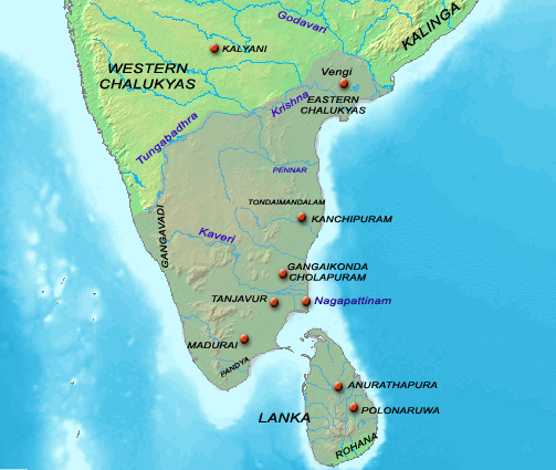
Map showing the extent of the Chola empire during en:Rajaraja Chola I. |
| ⧼wm-license-information-date⧽ | |
| ⧼wm-license-information-source⧽ | Source of map: http://www2.demis.nl/mapserver/mapper.asp (mention : "Disclaimer: With this statement DEMIS BV grants you permission to freely copy the PNG images returned by our server and use them for your own purposes, including web pages. We would appreciate a reference to our server but such a reference is not required, nor do we take responsibility for the accuracy or quality of the maps". at http://www2.demis.nl/mapserver/DataSrc.htm) Modified by myself using Adobe Photoshop |
| ⧼wm-license-information-author⧽ | User Venu62 on en.wikipedia |
| ⧼wm-license-information-permission⧽ (⧼wm-license-information-permission-reusing-text⧽) |
|
| ⧼wm-license-information-other-versions⧽ |
Originally from en.wikipedia; description page is (was) here
|
تاريخ الملف
اضغط على زمن/تاريخ لرؤية الملف كما بدا في هذا الزمن.
| زمن/تاريخ | صورة مصغرة | الأبعاد | مستخدم | تعليق | |
|---|---|---|---|---|---|
| حالي | ★ مراجعة معتمدة 08:17، 9 نوفمبر 2023 | | 503 × 425 (78 كيلوبايت) | Pastakhov (نقاش | مساهمات) | Upload https://upload.wikimedia.org/wikipedia/commons/6/68/Chola_map.png |
لا يمكنك استبدال هذا الملف.
وصلات
لا يوجد صفحات تصل لهذه الصورة.