ملف:COVID-19 cases in Arkansas by county.svg

حجم معاينة PNG لذلك الملف ذي الامتداد SVG: 689 × 600 بكسل. البعد الآخر: 2٬353 × 2٬048 بكسل.
الملف الأصلي (ملف SVG، أبعاده 4٬474 × 3٬895 بكسل، حجم الملف: 305 كيلوبايت)
وصف قصير
| ⧼wm-license-information-description⧽ |
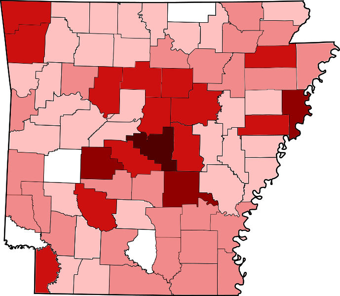
English: Map of Arkansas' counties where COVID-19 has been confirmed as of 23 March 2020. As this is a current outbreak, the map might not be up to date. Data from Arkansas Department of Health.
250+ Confirmed cases
75–249 Confirmed cases
20–74 Confirmed cases
5–19 Confirmed cases
1–4 Confirmed cases |
| ⧼wm-license-information-date⧽ | 2020 |
| ⧼wm-license-information-source⧽ | ⧼Wm-license-own-work⧽ |
| ⧼wm-license-information-author⧽ | Wwnws98 |
ترخيص
|
تاريخ الملف
اضغط على زمن/تاريخ لرؤية الملف كما بدا في هذا الزمن.
| زمن/تاريخ | صورة مصغرة | الأبعاد | مستخدم | تعليق | |
|---|---|---|---|---|---|
| حالي | ★ مراجعة معتمدة 01:09، 2 نوفمبر 2023 | | 4٬474 × 3٬895 (305 كيلوبايت) | Pastakhov (نقاش | مساهمات) | Upload https://upload.wikimedia.org/wikipedia/commons/3/31/COVID-19_cases_in_Arkansas_by_county.svg |
لا يمكنك استبدال هذا الملف.
وصلات
لا يوجد صفحات تصل لهذه الصورة.