ملف:Bywell St. Peter - geograph.org.uk - 1570129.jpg
لا توجد دقة أعلى متوفرة.
Bywell_St._Peter_-_geograph.org.uk_-_1570129.jpg (640 × 480 بكسل حجم الملف: 82 كيلوبايت، نوع MIME: image/jpeg)
وصف قصير
| ⧼wm-license-information-description⧽ |
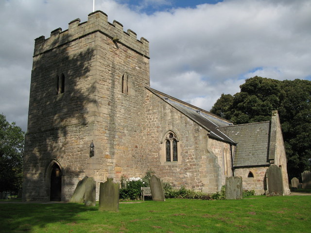
English: Bywell St. Peter In the Middle Ages, Bywell was an important settlement with flourishing local industry and there were two baronies, Baliol and Bolbec, adjoining each other. The parish of St. Peter was associated with the Baliol lands, and that of St. Andrew with Bolbec. The parish of St. Peter was ceded to the Benedictine house at Durham in 1174 and was consequently known as the "black church" from the colour of the Benedictine habit. St. Andrew's, the "white church", was in the gift of the Praemonstratentian or white canons of Blanchland. {Source: Leaflet "Welcome to Bywell". }
|
| ⧼wm-license-information-date⧽ | 2009 |
| ⧼wm-license-information-source⧽ | From geograph.org.uk |
| ⧼wm-license-information-author⧽ | Mike Quinn |
| ⧼wm-license-cc-attribution⧽ (قالب:I18n/Credit line) |
Mike Quinn / Bywell St. Peter / |
54°56′50″N 1°55′30″W / 54.947308°N 1.92510°W قالب:Object location
_heading:45)
ترخيص
تاريخ الملف
اضغط على زمن/تاريخ لرؤية الملف كما بدا في هذا الزمن.
| زمن/تاريخ | صورة مصغرة | الأبعاد | مستخدم | تعليق | |
|---|---|---|---|---|---|
| حالي | ★ مراجعة معتمدة 20:39، 17 أكتوبر 2023 | | 640 × 480 (82 كيلوبايت) | Pastakhov (نقاش | مساهمات) | Upload https://upload.wikimedia.org/wikipedia/commons/5/52/Bywell_St._Peter_-_geograph.org.uk_-_1570129.jpg |
لا يمكنك استبدال هذا الملف.
وصلات
لا يوجد صفحات تصل لهذه الصورة.