ملف:Burg in OH.png
لا توجد دقة أعلى متوفرة.
Burg_in_OH.png (327 × 367 بكسل حجم الملف: 5 كيلوبايت، نوع MIME: image/png)
وصف قصير
| ⧼wm-license-information-description⧽ |
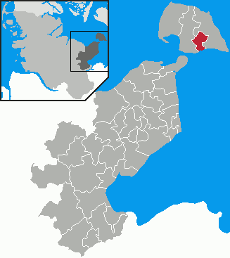
English: This map shows the area of the former Stadt (town) Burg auf Fehmarn in the Kreis (district) Ostholstein, Schleswig-Holstein, Germany.
Deutsch: Diese Karte zeigt das Gebiet der ehemaligen Stadt Burg auf Fehmarn im Kreis Ostholstein, Schleswig-Holstein, Deutschland.
|
| ⧼wm-license-information-date⧽ | 2007 |
| ⧼wm-license-information-source⧽ | selbst erstellt by ClausG |
| ⧼wm-license-information-author⧽ | |
| ⧼wm-license-information-permission⧽ (⧼wm-license-information-permission-reusing-text⧽) |
Ich, als der Urheber dieses Bildes, veröffentlichte dieses Bild unter der GNU-FDL. |
ترخيص
تاريخ الملف
اضغط على زمن/تاريخ لرؤية الملف كما بدا في هذا الزمن.
| زمن/تاريخ | صورة مصغرة | الأبعاد | مستخدم | تعليق | |
|---|---|---|---|---|---|
| حالي | ★ مراجعة معتمدة 00:58، 14 نوفمبر 2023 | | 327 × 367 (5 كيلوبايت) | Pastakhov (نقاش | مساهمات) | Upload https://upload.wikimedia.org/wikipedia/commons/4/42/Burg_in_OH.png |
لا يمكنك استبدال هذا الملف.
وصلات
لا يوجد صفحات تصل لهذه الصورة.