ملف:Brunel's Railway Bridge at Maidenhead - geograph.org.uk - 94793.jpg
لا توجد دقة أعلى متوفرة.
Brunel's_Railway_Bridge_at_Maidenhead_-_geograph.org.uk_-_94793.jpg (640 × 427 بكسل حجم الملف: 87 كيلوبايت، نوع MIME: image/jpeg)
وصف قصير
| ⧼wm-license-information-description⧽ |
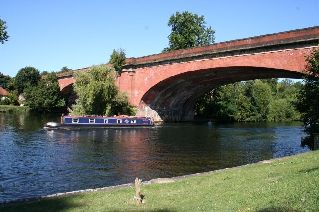
English: Brunel's Railway Bridge at Maidenhead. The bridge was designed Isambard Kingdom Brunel, engineer for the Great Western Railway. The railway from London to the West is carried across the River Thames on two brick arches, and the bridge was the widest and flattest in the world. Each span is 128 feet (39 m), with a rise of only 24 feet (7 m). The Thames Path passes under bridge, also known as the Sounding Arch because of its spectacular echo.
|
| ⧼wm-license-information-date⧽ | قالب:Taken on |
| ⧼wm-license-information-source⧽ | From geograph.org.uk |
| ⧼wm-license-information-author⧽ | Stephen Daglish |
| ⧼wm-license-cc-attribution⧽ (قالب:I18n/Credit line) |
Stephen Daglish / Brunel's Railway Bridge at Maidenhead / |
51°31′16″N 0°42′04″W / 51.5212°N 0.701°W قالب:Object location
_heading:315)
ترخيص
تاريخ الملف
اضغط على زمن/تاريخ لرؤية الملف كما بدا في هذا الزمن.
| زمن/تاريخ | صورة مصغرة | الأبعاد | مستخدم | تعليق | |
|---|---|---|---|---|---|
| حالي | ★ مراجعة معتمدة 21:19، 5 أكتوبر 2023 | | 640 × 427 (87 كيلوبايت) | Pastakhov (نقاش | مساهمات) | Upload https://upload.wikimedia.org/wikipedia/commons/3/3f/Brunel%27s_Railway_Bridge_at_Maidenhead_-_geograph.org.uk_-_94793.jpg |
لا يمكنك استبدال هذا الملف.
وصلات
لا يوجد صفحات تصل لهذه الصورة.