ملف:Bridgend from Callander Crags - geograph.org.uk - 222369.jpg
لا توجد دقة أعلى متوفرة.
Bridgend_from_Callander_Crags_-_geograph.org.uk_-_222369.jpg (640 × 480 بكسل حجم الملف: 144 كيلوبايت، نوع MIME: image/jpeg)
وصف قصير
| ⧼wm-license-information-description⧽ |
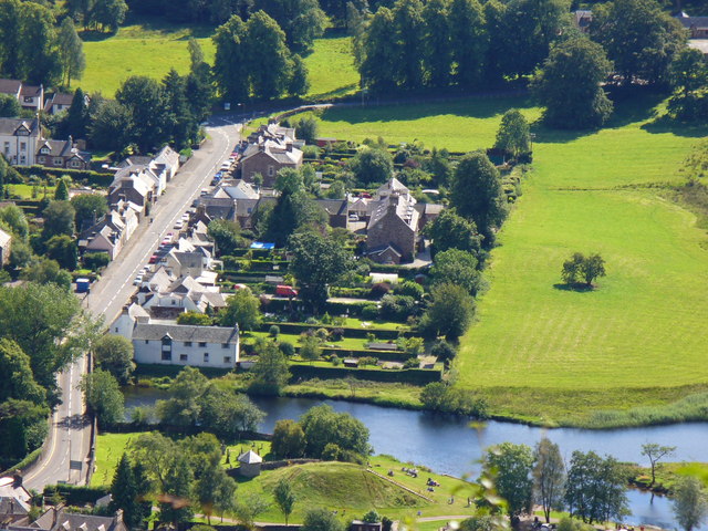
English: Bridgend from Callander Crags. Lying south of the bridge, this is the oldest part of Callander. The long and narrow burgage plots are seen running away at right angles from the street. The newer, planned gridiron, part of the village is north of the river ie bottom edge of the photograph. Also visible at this edge is the small hill, Tom na Kessog, which may have been built as a Norman motte.
|
| ⧼wm-license-information-date⧽ | 2006 |
| ⧼wm-license-information-source⧽ | From geograph.org.uk |
| ⧼wm-license-information-author⧽ | Colin Smith |
| ⧼wm-license-cc-attribution⧽ (قالب:I18n/Credit line) |
Colin Smith / Bridgend from Callander Crags / |
56°14′55″N 4°12′47″W / 56.2487°N 4.213°W قالب:Object location
_heading:202)
ترخيص
تاريخ الملف
اضغط على زمن/تاريخ لرؤية الملف كما بدا في هذا الزمن.
| زمن/تاريخ | صورة مصغرة | الأبعاد | مستخدم | تعليق | |
|---|---|---|---|---|---|
| حالي | ★ مراجعة معتمدة 11:05، 4 نوفمبر 2023 | | 640 × 480 (144 كيلوبايت) | Pastakhov (نقاش | مساهمات) | Upload https://upload.wikimedia.org/wikipedia/commons/8/87/Bridgend_from_Callander_Crags_-_geograph.org.uk_-_222369.jpg |
لا يمكنك استبدال هذا الملف.
وصلات
لا يوجد صفحات تصل لهذه الصورة.