ملف:Boko Haram conflict map.png
لا توجد دقة أعلى متوفرة.
Boko_Haram_conflict_map.png (270 × 221 بكسل حجم الملف: 22 كيلوبايت، نوع MIME: image/png)
| ⧼wm-license-information-description⧽ |
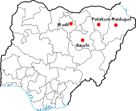
Location of the four cities in north eastern Nigeria where the Boko Haram conflict took place. |
| ⧼wm-license-information-date⧽ | 2009-08-05 00:00 (UTC) |
| ⧼wm-license-information-source⧽ | |
| ⧼wm-license-information-author⧽ |
|
قالب:Original upload log
This image is a derivative work of the following images:
- File:Locator_Map_blank-Nigeria.png licensed with GFDL-en
- 2006-11-10T15:08:33Z PhilFree 270x221 (17405 Bytes) Blank locator Map for city in Nigeria From: [[:en:Benin City]] (modified without red point) [[Category:Maps of Nigeria]]
تاريخ الملف
اضغط على زمن/تاريخ لرؤية الملف كما بدا في هذا الزمن.
| زمن/تاريخ | صورة مصغرة | الأبعاد | مستخدم | تعليق | |
|---|---|---|---|---|---|
| حالي | ★ مراجعة معتمدة 16:13، 21 أكتوبر 2023 | | 270 × 221 (22 كيلوبايت) | Pastakhov (نقاش | مساهمات) | Upload https://upload.wikimedia.org/wikipedia/commons/c/ce/Boko_Haram_conflict_map.png |
لا يمكنك استبدال هذا الملف.
وصلات
لا يوجد صفحات تصل لهذه الصورة.