ملف:Bhagirathi river map.JPG
حجم هذه المعاينة: 391 × 600 بكسل. البعد الآخر: 1٬304 × 2٬000 بكسل.
الملف الأصلي (1٬304 × 2٬000 بكسل حجم الملف: 192 كيلوبايت، نوع MIME: image/jpeg)
| ⧼wm-license-information-description⧽ |
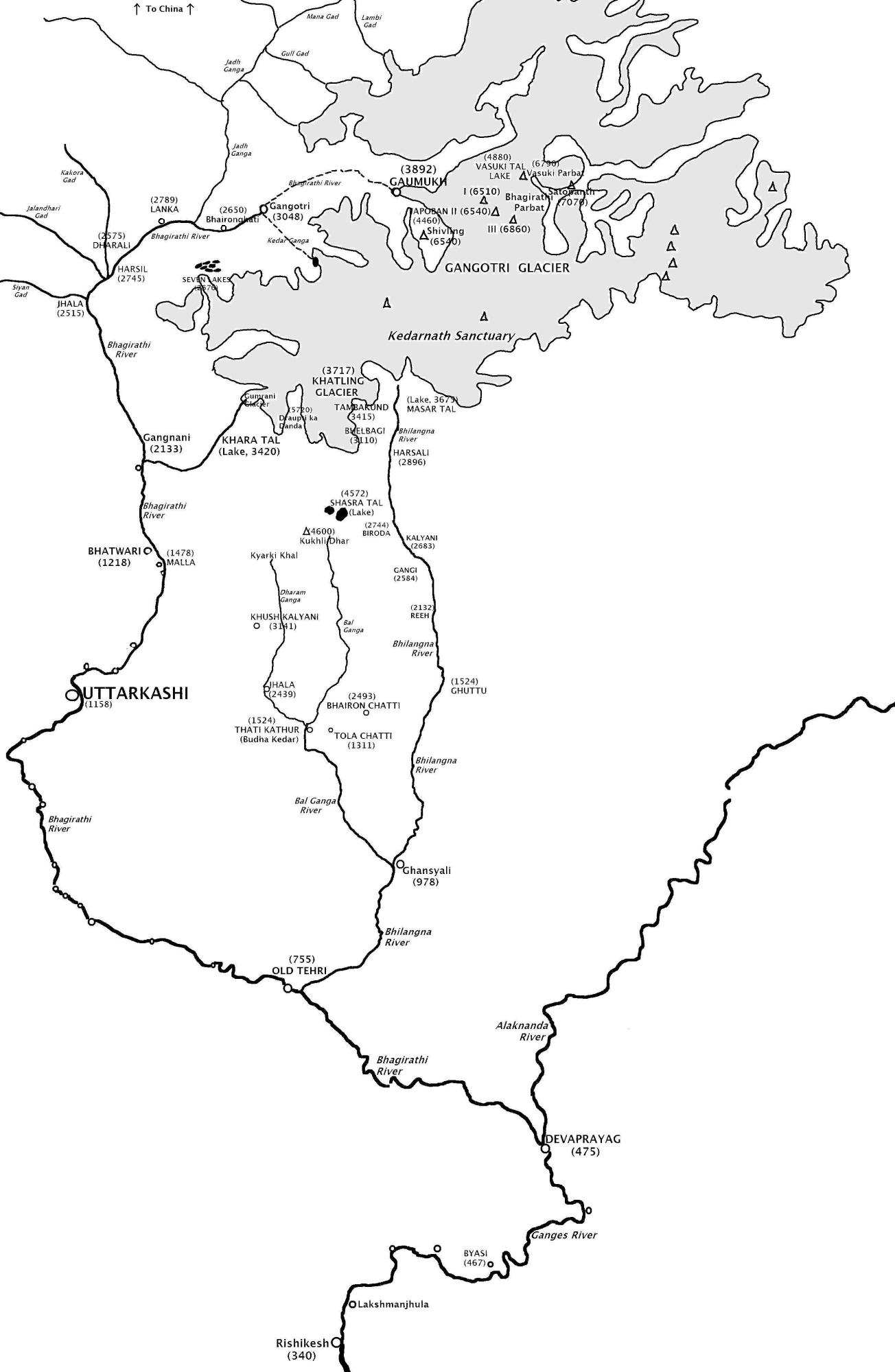
English: Map showing the Himalayan headwaters of the Bhagirathi River (as well as its course), the source stream of the Ganges river of the Indian subcontinent. That map in turn is based on the map of the region produced by the Surveyor General of India.
|
|||||
| ⧼wm-license-information-date⧽ | 2009 | |||||
| ⧼wm-license-information-source⧽ | Created and uploaded by author | |||||
| ⧼wm-license-information-author⧽ | Fowler&fowler«Talk». | |||||
| ⧼wm-license-information-permission⧽ (⧼wm-license-information-permission-reusing-text⧽) |
|

قالب:Original upload log
قالب:Transferred from قالب:Original description page
- 2009-04-05 19:01 Fowler&fowler 1304×2000× (196098 bytes) {{Information |Description = Map showing the [[Himalayas|Himalayan]] headwaters of the [[Bhagirathi River]] (as well as its course), the source stream of the [[Ganges river]] of the [[Indian subcontinent]]. The map is based on the map in {{Harvard re
تاريخ الملف
اضغط على زمن/تاريخ لرؤية الملف كما بدا في هذا الزمن.
| زمن/تاريخ | صورة مصغرة | الأبعاد | مستخدم | تعليق | |
|---|---|---|---|---|---|
| حالي | ★ مراجعة معتمدة 02:12، 9 ديسمبر 2023 | | 1٬304 × 2٬000 (192 كيلوبايت) | Pastakhov (نقاش | مساهمات) | Upload https://upload.wikimedia.org/wikipedia/commons/8/80/Bhagirathi_river_map.JPG |
لا يمكنك استبدال هذا الملف.
وصلات
لا يوجد صفحات تصل لهذه الصورة.