ملف:Belgische Gerechtelijke Arrondissementen (2012).png

حجم هذه المعاينة: 717 × 599 بكسل. البعد الآخر: 897 × 750 بكسل.
الملف الأصلي (897 × 750 بكسل حجم الملف: 60 كيلوبايت، نوع MIME: image/png)
وصف قصير
| ⧼wm-license-information-description⧽ |
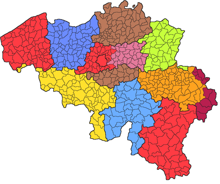
(Dutch) English: Map of Belgium with the 12 judicial arrondissements, after the 2012 reform: the ten provinces, Brussels and the German-speaking community.
Français : Carte de la Belgique avec les 12 arrondissements judiciaires, après la réforme de 2012 : les dix provinces, Bruxelles et la communauté germanophone.
|
| ⧼wm-license-information-date⧽ | 2012 |
| ⧼wm-license-information-source⧽ | File:Belgische Gerechtelijke Arrondissementen.png |
| ⧼wm-license-information-author⧽ | SPQRobin, Rubenho |
ترخيص
تاريخ الملف
اضغط على زمن/تاريخ لرؤية الملف كما بدا في هذا الزمن.
| زمن/تاريخ | صورة مصغرة | الأبعاد | مستخدم | تعليق | |
|---|---|---|---|---|---|
| حالي | ★ مراجعة معتمدة 23:37، 5 أكتوبر 2023 | | 897 × 750 (60 كيلوبايت) | Pastakhov (نقاش | مساهمات) | Upload https://upload.wikimedia.org/wikipedia/commons/8/8e/Belgische_Gerechtelijke_Arrondissementen_%282012%29.png |
لا يمكنك استبدال هذا الملف.
وصلات
لا يوجد صفحات تصل لهذه الصورة.
.png&oldid=2990639)