ملف:Battle of Magersfontein Map.png
لا توجد دقة أعلى متوفرة.
Battle_of_Magersfontein_Map.png (425 × 346 بكسل حجم الملف: 18 كيلوبايت، نوع MIME: image/png)
| ⧼wm-license-information-description⧽ |
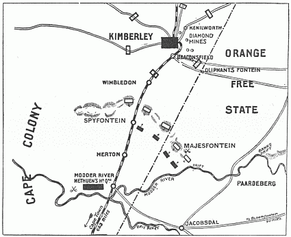
Map showing positions at the Battle of Magersfontein, 11 December 1899.
|
| ⧼wm-license-information-date⧽ | 1900 |
| ⧼wm-license-information-source⧽ | "South Africa and the Transvaal War, Vol. 2 (of 6). From the Commencement of the War to the Battle of Colenso" by Louis Creswicke. Published by T. C. & E. C. JACK EDINBURGH, 1900. Downloaded from Project Gutenberg at http://www.gutenberg.org/etext/26198 |
| ⧼wm-license-information-author⧽ | Louis Creswicke |
| ⧼wm-license-information-permission⧽ (⧼wm-license-information-permission-reusing-text⧽) |
Copyright expired.
هذه الصورة هي ضمن الملكية عامة بسبب إنتهاء فترة صلاحية حقوقها في الولايات المتحدة الأمريكية و أي دولة أخرى ينص قانونها على مرور 70 سنة كحد أعلى على وفاة المنتج لإنتهاء صلاحية الحقوق.
|
تاريخ الملف
اضغط على زمن/تاريخ لرؤية الملف كما بدا في هذا الزمن.
| زمن/تاريخ | صورة مصغرة | الأبعاد | مستخدم | تعليق | |
|---|---|---|---|---|---|
| حالي | ★ مراجعة معتمدة 03:59، 22 أكتوبر 2023 | | 425 × 346 (18 كيلوبايت) | Pastakhov (نقاش | مساهمات) | Upload https://upload.wikimedia.org/wikipedia/commons/7/7f/Battle_of_Magersfontein_Map.png |
لا يمكنك استبدال هذا الملف.
وصلات
لا يوجد صفحات تصل لهذه الصورة.