ملف:Banks Peninsula from space.jpg
Banks_Peninsula_from_space.jpg (300 × 279 بكسل حجم الملف: 19 كيلوبايت، نوع MIME: image/jpeg)
وصف قصير
from en wikipedia
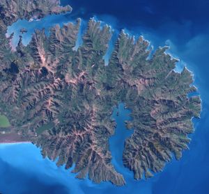
This shows Banks Peninsula, including Lyttelton Harbour and Akaroa Harbour, in Canterbury, New Zealand.
This image was acquired by the Enhanced Thematic Mapper plus (ETM+) sensor flying aboard the Landsat 7 satellite on September 25, 2001.
Image courtesy Jacques Descloitres, MODIS Land Rapid Response Team at NASA GSFC.
SOURCE: Large image Archive copy at the Internet Archive from NASA Earth Observatory
”The purpose of NASA's Earth Observatory is to provide a freely-accessible publication on the Internet where the public can obtain new satellite imagery and scientific information about our home planet. The focus is on Earth's climate and environmental change. In particular, we hope our site is useful to public media and educators. Any and all materials published on the Earth Observatory are freely available for re-publication or re-use, except where copyright is indicated. We ask that NASA's Earth Observatory be given credit for its original materials.”
تاريخ الملف
اضغط على زمن/تاريخ لرؤية الملف كما بدا في هذا الزمن.
| زمن/تاريخ | صورة مصغرة | الأبعاد | مستخدم | تعليق | |
|---|---|---|---|---|---|
| حالي | ★ مراجعة معتمدة 11:21، 4 ديسمبر 2023 | | 300 × 279 (19 كيلوبايت) | Pastakhov (نقاش | مساهمات) | Upload https://upload.wikimedia.org/wikipedia/commons/f/ff/Banks_Peninsula_from_space.jpg |
لا يمكنك استبدال هذا الملف.
وصلات
لا يوجد صفحات تصل لهذه الصورة.