ملف:Autoroute A20.PNG

حجم هذه المعاينة: 298 × 599 بكسل. البعد الآخر: 454 × 913 بكسل.
الملف الأصلي (454 × 913 بكسل حجم الملف: 75 كيلوبايت، نوع MIME: image/png)
وصف قصير
| ⧼wm-license-information-description⧽ |
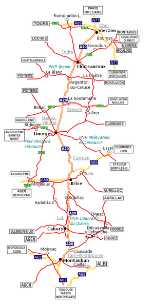
English: Map of the French motorway A20, between Vierzon (Cher) and Montauban (Tarn-et-Garonne)
Français : Carte de l'autoroute française A20, entre Vierzon (Cher) et Montauban (Tarn-et-Garonne)
Español: Mapa de la autopista francesa A20 entre Vierzon (Cher) y Montauban (Tarn-et-Garonne)
(Dutch) |
| ⧼wm-license-information-date⧽ | 2008 |
| ⧼wm-license-information-source⧽ | ⧼Wm-license-own-work⧽ |
| ⧼wm-license-information-author⧽ | Babsy |
ترخيص
|

تاريخ الملف
اضغط على زمن/تاريخ لرؤية الملف كما بدا في هذا الزمن.
| زمن/تاريخ | صورة مصغرة | الأبعاد | مستخدم | تعليق | |
|---|---|---|---|---|---|
| حالي | ★ مراجعة معتمدة 04:38، 25 أكتوبر 2023 | | 454 × 913 (75 كيلوبايت) | Pastakhov (نقاش | مساهمات) | Upload https://upload.wikimedia.org/wikipedia/commons/2/2a/Autoroute_A20.PNG |
لا يمكنك استبدال هذا الملف.
وصلات
لا يوجد صفحات تصل لهذه الصورة.