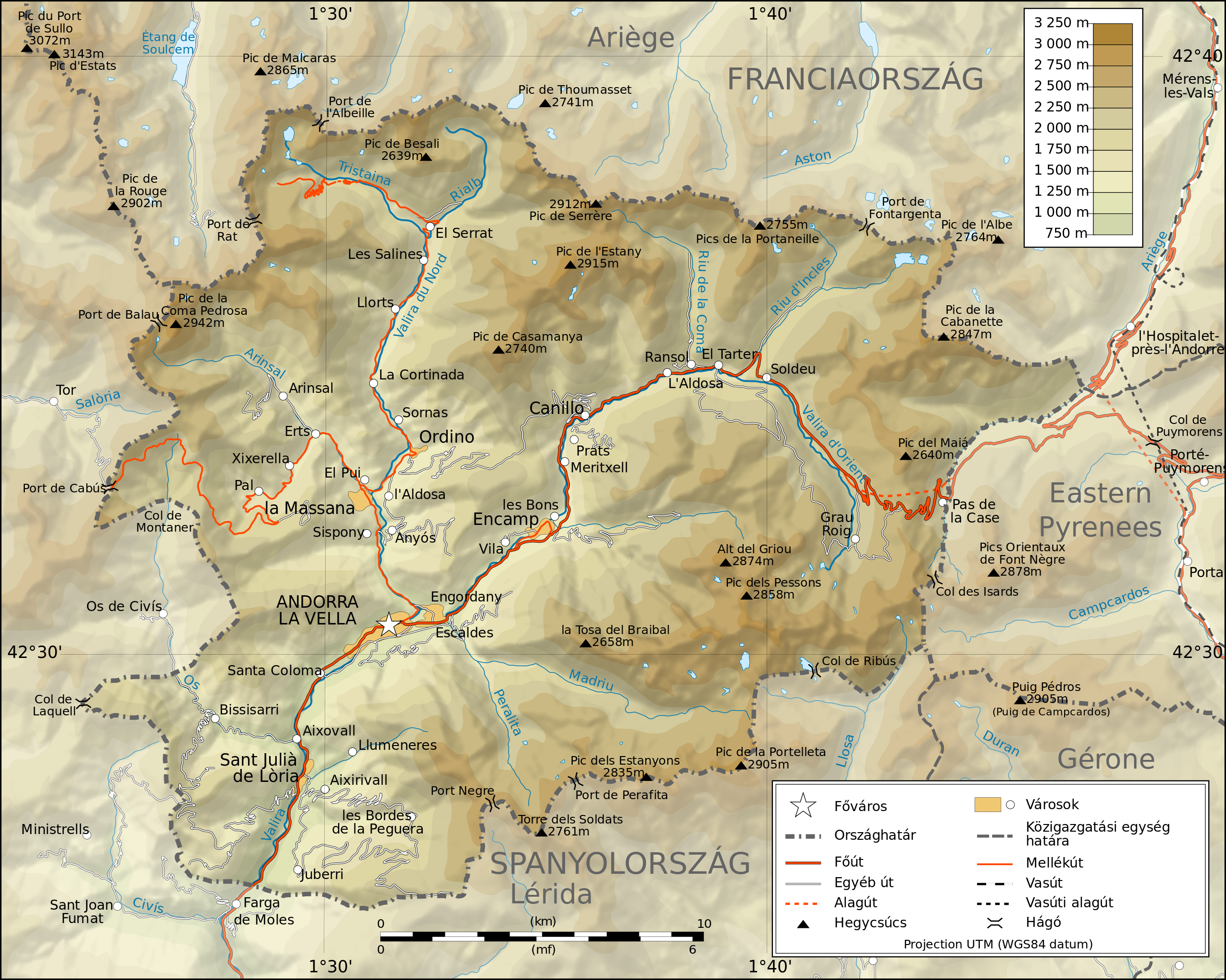
ملف:Andorra topographic map-hu.svg

حجم معاينة PNG لذلك الملف ذي الامتداد SVG: 750 × 600 بكسل. البعد الآخر: 2٬560 × 2٬048 بكسل.
الملف الأصلي (ملف SVG، أبعاده 1٬625 × 1٬300 بكسل، حجم الملف: 1٫22 ميجابايت)
وصف قصير
42°33′00″N 01°36′00″E / 42.55000°N 1.60000°E
| ⧼wm-license-information-description⧽ |
(مجرية) |
| ⧼wm-license-information-date⧽ | 2010-01-22 18:00 (UTC) |
| ⧼wm-license-information-source⧽ | |
| ⧼wm-license-information-author⧽ |
|
| ⧼wm-license-information-other-versions⧽ |
| [This is a retouched picture, which means that it has been digitally altered from its original version. The original can be viewed here: Andorra_topographic_map-en.svg. Modifications made by zetrs.] Error: {{Lang}}: text has italic markup (help)
|
ترخيص
|

قالب:Original upload log
This image is a derivative work of the following images:
- File:Andorra_topographic_map-en.svg licensed with Cc-by-sa-3.0, GFDL
- 2009-03-30T01:34:11Z Goldsztajn 1625x1300 (1634127 Bytes) {{Information |Description={{en|1=Map of Andorra}} |Source=http://commons.wikimedia.org/wiki/File:Andorra_topographic_map-fr.svg |Author=[[User:Sting]] [[fr:Utilisateur:Sting]], english translation |Date=2009-03-30 |Permissio
تاريخ الملف
اضغط على زمن/تاريخ لرؤية الملف كما بدا في هذا الزمن.
| زمن/تاريخ | صورة مصغرة | الأبعاد | مستخدم | تعليق | |
|---|---|---|---|---|---|
| حالي | ★ مراجعة معتمدة 07:25، 14 ديسمبر 2023 | | 1٬625 × 1٬300 (1٫22 ميجابايت) | Pastakhov (نقاش | مساهمات) | Upload https://upload.wikimedia.org/wikipedia/commons/6/67/Andorra_topographic_map-hu.svg |
لا يمكنك استبدال هذا الملف.
وصلات
لا يوجد صفحات تصل لهذه الصورة.