ملف:Andorra topographic map-fr.svg

حجم معاينة PNG لذلك الملف ذي الامتداد SVG: 750 × 600 بكسل. البعد الآخر: 2٬560 × 2٬048 بكسل.
الملف الأصلي (ملف SVG، أبعاده 1٬625 × 1٬300 بكسل، حجم الملف: 1٫58 ميجابايت)
وصف قصير
42°33′00″N 01°36′00″E / 42.55000°N 1.60000°E
| ⧼wm-license-information-description⧽ |
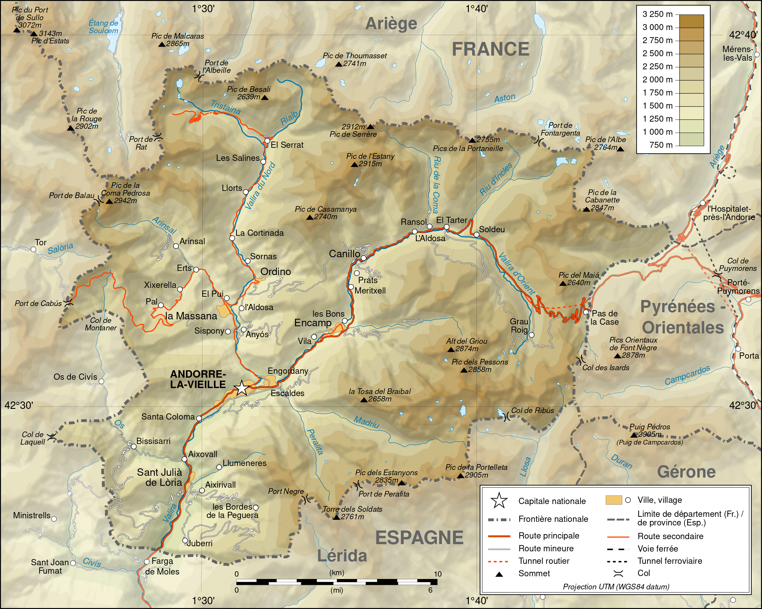
Deutsch: Topographische Karte von Andorra, französische Version English: Topographic map in French of Andorra Français : Carte topographique en français de l'Andorre
|
| ⧼wm-license-information-date⧽ | 2008 |
| ⧼wm-license-information-source⧽ | English: Own work ; Topographic data from the NASA Shuttle Radar Topography Mission (SRTM3 v.2) (public domain) edited with 3DEM and dlgv32 Pro and vectorized with Inkscape ; UTM projection ; WGS84 datum ; shaded relief (composite image of N-W, W and N lightning positions) ; Reference used for the additional data : * Topographic maps available on the site of the Ministeri d'Urbanisme i Ordenament Territorial of Andorra ; * Géoportail France ; Approximate scale of topographic data : 1:400,000 (accuracy : about 100 m) ; Note : The shaded relief is a raster image embedded in the SVG file. Français : Création personnelle ; Données topographiques de la NASA Shuttle Radar Topography Mission (SRTM3 v.2) (domaine public) éditées avec 3DEM et dlgv32 Pro et vectorisées avec Inkscape ; projection UTM ; WGS84 datum ; relief ombré (image composite d'éclairages du N-O, O et N) ; Références utilisées pour les données complémentaires : * Cartes topographiques disponibles sur le site du Ministeri d'Urbanisme i Ordenament Territorial d'Andorre ; * Géoportail France ; Échelle approximative des données topographiques : 1:400 000 (précision : environ 100 m) ; Note : Le relief ombré est une image bitmap embarquée dans le fichier SVG. Approximate geographic limits of the map (3" close) : * SW corner : 42°24'30"N – 01°22'40"E * SE corner : 42°24'30"N – 01°50'20"E * NE corner : 42°40'55"N – 01°50'25"E * NW corner : 42°40'55"N – 01°22'35"E |
| ⧼wm-license-information-author⧽ | Eric Gaba (Sting - fr:Sting) |
| ⧼wm-license-information-permission⧽ (⧼wm-license-information-permission-reusing-text⧽) |
|
| ⧼wm-license-information-other-versions⧽ |
قالب:Atelier graphique carte قالب:Translation possible
ترخيص
|

تاريخ الملف
اضغط على زمن/تاريخ لرؤية الملف كما بدا في هذا الزمن.
| زمن/تاريخ | صورة مصغرة | الأبعاد | مستخدم | تعليق | |
|---|---|---|---|---|---|
| حالي | ★ مراجعة معتمدة 17:56، 13 نوفمبر 2023 | | 1٬625 × 1٬300 (1٫58 ميجابايت) | Pastakhov (نقاش | مساهمات) | Upload https://upload.wikimedia.org/wikipedia/commons/8/88/Andorra_topographic_map-fr.svg |
لا يمكنك استبدال هذا الملف.
وصلات
لا يوجد صفحات تصل لهذه الصورة.