ملف:Andorra topographic map-ca.svg

الملف الأصلي (ملف SVG، أبعاده 1٬625 × 1٬300 بكسل، حجم الملف: 1٫58 ميجابايت)
42°33′00″N 01°36′00″E / 42.55000°N 1.60000°E
| ⧼wm-license-information-description⧽ |
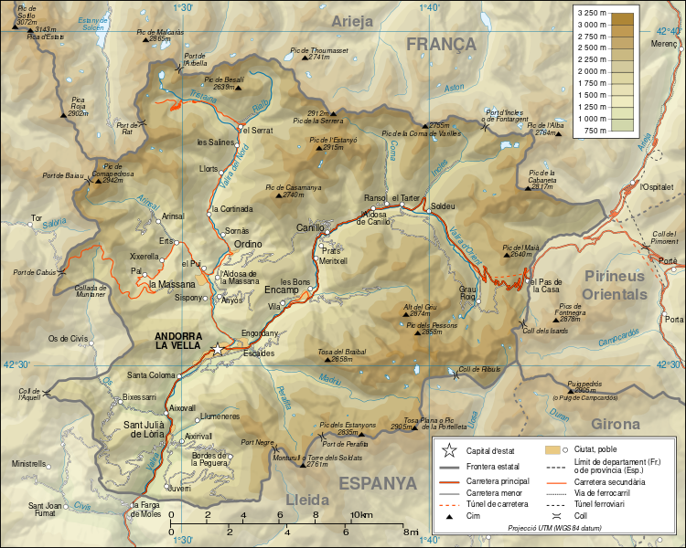
Català: Mapa topogràfic d'Andorra en versió en català English: Topographic map in Catalan of Andorra Français : Carte topographique en catalan de l'Andorre
|
| ⧼wm-license-information-date⧽ | 2008-09-01 15:28 (UTC) |
| ⧼wm-license-information-source⧽ | Català: Traducció de Andorra_topographic_map-fr.svg
L'original té les dades topogràfiques de la Missió NASA Shuttle Radar Topography (SRTM3 v.2) (domini públic) editat amb 3DEM i dlgv32 Pro i vectoritzat amb l'Inkscape; projecció UTM; WGS84 datum; relleu ombrejat (imatge composta de posicions lluminoses de NO, O i N). Referència per les dades addicionals:
Escala aproximada de les dades topogràfiques: 1:400.000 (precisió: uns 100 m); Nota: El relleu ombrejat és una imatge rastrejada immersa en el fitxer SVG. English: Translation from Andorra_topographic_map-fr.svg
Topographic data from the NASA Shuttle Radar Topography Mission (SRTM3 v.2) (public domain) edited with 3DEM and dlgv32 Pro and vectorized with Inkscape; UTM projection; WGS84 datum; shaded relief (composite image of N-W, W and N lightning positions); Reference used for the additional data:
Approximate scale of topographic data: 1:400,000 (accuracy: about 100 m); Note : The shaded relief is a raster image embedded in the SVG file. Français : Traduction d'Andorra_topographic_map-fr.svg
Données topographiques de la NASA Shuttle Radar Topography Mission (SRTM3 v.2) (domaine public) éditées avec 3DEM et dlgv32 Pro et vectorisées avec Inkscape ; projection UTM ; WGS84 datum ; relief ombré (image composite d'éclairages du N-O, O et N) ; Références utilisées pour les données complémentaires :
Échelle approximative des données topographiques : 1:400 000 (précision : environ 100 m) ; Note : Le relief ombré est une image bitmap embarquée dans le fichier SVG. Approximate geographic limits of the map (3" close):
|
| ⧼wm-license-information-author⧽ |
|
| ⧼wm-license-information-other-versions⧽ |
|

قالب:Original upload log
This image is a derivative work of the following images:
- Image:Andorra_topographic_map-fr.svg licensed with Cc-by-sa-3.0,2.5,2.0,1.0
- 2008-06-12T20:03:47Z Sting 1625x1300 (1654623 Bytes) Correction on a name.
- 2008-03-07T14:37:41Z Sting 1625x1300 (1654334 Bytes) Improved shaded relief and other details
- 2008-02-28T04:26:38Z Sting 1625x1300 (1275242 Bytes) {{Location|42|33|00|N|01|36|00|E|scale:200000}} {{Information |Description={{en|Topographic map in French of [[:Category:Andorra|Andorra]]}}{{fr|Carte topographique en français de l'[[:Category:Andorra|Andorre]]}} |Source={
تاريخ الملف
اضغط على زمن/تاريخ لرؤية الملف كما بدا في هذا الزمن.
| زمن/تاريخ | صورة مصغرة | الأبعاد | مستخدم | تعليق | |
|---|---|---|---|---|---|
| حالي | ★ مراجعة معتمدة 07:24، 14 ديسمبر 2023 | | 1٬625 × 1٬300 (1٫58 ميجابايت) | Pastakhov (نقاش | مساهمات) | Upload https://upload.wikimedia.org/wikipedia/commons/0/0c/Andorra_topographic_map-ca.svg |
لا يمكنك استبدال هذا الملف.
وصلات
لا يوجد صفحات تصل لهذه الصورة.