ملف:Airliner over Donington Circuit - geograph.org.uk - 1222575.jpg
لا توجد دقة أعلى متوفرة.
Airliner_over_Donington_Circuit_-_geograph.org.uk_-_1222575.jpg (640 × 384 بكسل حجم الملف: 76 كيلوبايت، نوع MIME: image/jpeg)
وصف قصير
| ⧼wm-license-information-description⧽ |
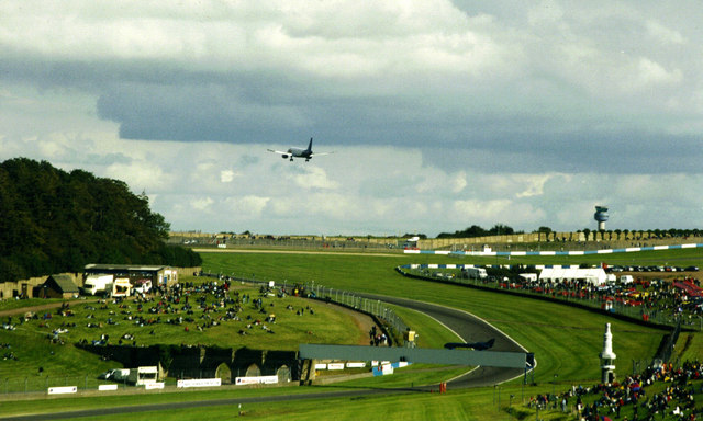
English: Airliner over Donington Circuit This jet's low pass emphasises how close the East Midlands Airport is to the edge of the circuit. The control tower is clearly visible on the right horizon.
Those strange clouds are real - not very bad retouching. Despite appearances I've not removed an advert from Starkey's bridge either. In the 1930s the Grand Prix track passed through one of the narrow arches on the left of the bridge. The Donington track is currently having a major remodelling to host future British GPs. The photo date is a guess. |
| ⧼wm-license-information-date⧽ | 1990 |
| ⧼wm-license-information-source⧽ | From geograph.org.uk |
| ⧼wm-license-information-author⧽ | John Goldsmith |
| ⧼wm-license-cc-attribution⧽ (قالب:I18n/Credit line) |
John Goldsmith / Airliner over Donington Circuit / |
52°49′58″N 1°22′40″W / 52.83290°N 1.3777°W قالب:Object location
_heading:112)
ترخيص
تاريخ الملف
اضغط على زمن/تاريخ لرؤية الملف كما بدا في هذا الزمن.
| زمن/تاريخ | صورة مصغرة | الأبعاد | مستخدم | تعليق | |
|---|---|---|---|---|---|
| حالي | ★ مراجعة معتمدة 12:34، 12 يناير 2024 | | 640 × 384 (76 كيلوبايت) | Pastakhov (نقاش | مساهمات) | Upload https://upload.wikimedia.org/wikipedia/commons/5/5a/Airliner_over_Donington_Circuit_-_geograph.org.uk_-_1222575.jpg |
لا يمكنك استبدال هذا الملف.
وصلات
لا يوجد صفحات تصل لهذه الصورة.