ملف:Airfield entrance - St Athan - geograph.org.uk - 1516094.jpg
لا توجد دقة أعلى متوفرة.
Airfield_entrance_-_St_Athan_-_geograph.org.uk_-_1516094.jpg (640 × 425 بكسل حجم الملف: 71 كيلوبايت، نوع MIME: image/jpeg)
وصف قصير
| ⧼wm-license-information-description⧽ |
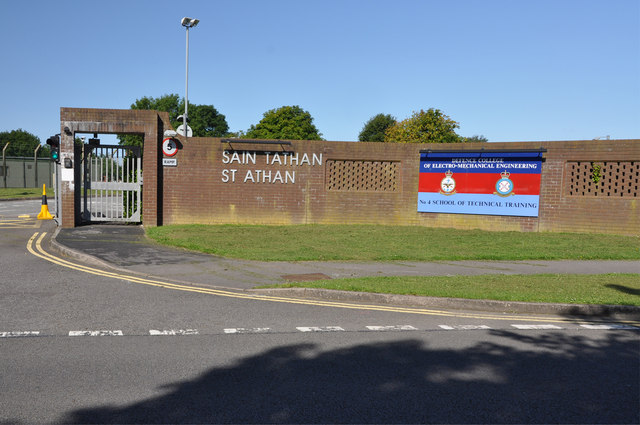
English: Airfield entrance - St Athan During its life as an RAF unit the airfield was pretty much divided into two halves with separate functions of maintenance and of training. This is one side of the entrance gate on East Camp that held the training facility and some elements of maintenance.
The site is now in the hands of the Welsh Assembly Government (WAG)hence its apparent crisis of identity. This photograph shows it to be the home of the Defence College of Electro-Mechanical Engineering, No 4 School of Technical Training. One of two adjacent imposing gates that lead to confusion among visitors. |
| ⧼wm-license-information-date⧽ | 2009 |
| ⧼wm-license-information-source⧽ | From geograph.org.uk |
| ⧼wm-license-information-author⧽ | Mick Lobb |
| ⧼wm-license-cc-attribution⧽ (قالب:I18n/Credit line) |
Mick Lobb / Airfield entrance - St Athan / |
51°24′40″N 3°25′03″W / 51.411085°N 3.41739°W قالب:Object location
_heading:270)
ترخيص
تاريخ الملف
اضغط على زمن/تاريخ لرؤية الملف كما بدا في هذا الزمن.
| زمن/تاريخ | صورة مصغرة | الأبعاد | مستخدم | تعليق | |
|---|---|---|---|---|---|
| حالي | ★ مراجعة معتمدة 10:58، 29 أكتوبر 2023 | | 640 × 425 (71 كيلوبايت) | Pastakhov (نقاش | مساهمات) | Upload https://upload.wikimedia.org/wikipedia/commons/f/f6/Airfield_entrance_-_St_Athan_-_geograph.org.uk_-_1516094.jpg |
لا يمكنك استبدال هذا الملف.
وصلات
لا يوجد صفحات تصل لهذه الصورة.