ملف:Aegean Sea map bathymetry-es.svg

حجم معاينة PNG لذلك الملف ذي الامتداد SVG: 493 × 599 بكسل. البعد الآخر: 1٬684 × 2٬048 بكسل.
الملف الأصلي (ملف SVG، أبعاده 3٬750 × 4٬560 بكسل، حجم الملف: 3٫42 ميجابايت)
وصف قصير
قالب:Igen
| ⧼wm-license-information-description⧽ |
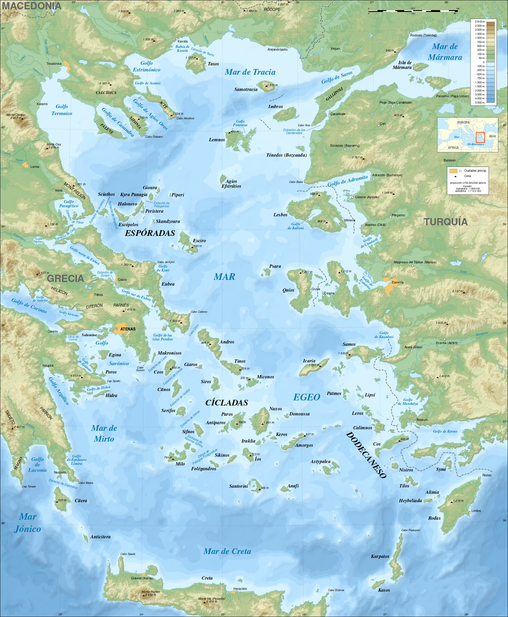
ملف:Human-dialog-warning.svg Note: this SVG map has a display bug on this page (size too large?) but works fine in Inkscape. Consider using the قالب:F in the articles pages. English: Bathymetric map in French of the Aegean Sea, Mediterranean Sea. Note: The background map is a raster image embedded in the SVG file. Français : Carte bathymétrique en français de la Mer Égée, Mer Méditerranée. *UTM projection; WGS84 datum ; shaded reliefNote : Le fond de carte est une image bitmap embarquée dans le fichier SVG. *Scales: **Topography: 1:608,000 (precision 152 m) **Bathymetry: 1:7,512,000 (precision 1,878 m) |
| ⧼wm-license-information-date⧽ | 2009 |
| ⧼wm-license-information-source⧽ | قالب:F |
| ⧼wm-license-information-author⧽ | ecelan |
| ⧼wm-license-information-other-versions⧽ |
ترخيص
|

قالب:Original upload log
This image is a derivative work of the following images:
- قالب:F licensed with Cc-by-sa-3.0,2.5,2.0,1.0, GFDL
- 2009-02-08T00:35:16Z Sting 3750x4560 (3597775 Bytes) Correcting display bug - new try - step #2
- 2009-02-08T00:29:02Z Sting 3750x4560 (410188 Bytes) Correcting display bug - new try - step #1
- 2009-02-08T00:14:50Z Sting 3750x4560 (3740562 Bytes) Correcting display bug
- 2009-02-06T07:54:54Z Future Perfect at Sunrise 3750x4560 (3742390 Bytes) null edit, re-uploading to try to force display to be reset, background image wasn't displaying
- 2009-02-06T07:52:12Z Future Perfect at Sunrise 3750x4560 (3742390 Bytes) null edit, re-uploading to try to force display to be reset, background image wasn't displaying
- 2008-09-28T21:11:49Z Sting 3750x4560 (3742390 Bytes) Completely new background using ETOPO1 data ; new standard colors ; some additional labels
- 2007-11-27T13:16:40Z Sting 3750x4560 (4078448 Bytes) Elevation on Chios
- 2007-11-26T23:25:43Z Sting 3750x4560 (4078446 Bytes) correction
- 2007-11-21T22:42:53Z Sting 3750x4560 (4079234 Bytes) Additional sea names
- 2007-11-21T20:21:26Z Sting 3750x4560 (4078039 Bytes) Additional key
- 2007-11-21T19:10:35Z Sting 3750x4560 (4072878 Bytes) {{Information |Description=Bathymetric map in French of the [[:Category:Aegean Sea|Aegean Sea]], Mediterranean Sea |Source=Own work ;Raster relief background map : [http://www2.jpl.nasa.gov/srtm NASA Shuttle Radar Topography
تاريخ الملف
اضغط على زمن/تاريخ لرؤية الملف كما بدا في هذا الزمن.
| زمن/تاريخ | صورة مصغرة | الأبعاد | مستخدم | تعليق | |
|---|---|---|---|---|---|
| حالي | ★ مراجعة معتمدة 12:23، 14 ديسمبر 2023 | | 3٬750 × 4٬560 (3٫42 ميجابايت) | Pastakhov (نقاش | مساهمات) | Upload https://upload.wikimedia.org/wikipedia/commons/1/18/Aegean_Sea_map_bathymetry-es.svg |
لا يمكنك استبدال هذا الملف.
وصلات
لا يوجد صفحات تصل لهذه الصورة.