ملف:AF447SeaBottom-it.jpg

حجم هذه المعاينة: 673 × 599 بكسل. البعدان الآخران: 2٬300 × 2٬048 بكسل | 2٬808 × 2٬500 بكسل.
الملف الأصلي (2٬808 × 2٬500 بكسل حجم الملف: 3٫8 ميجابايت، نوع MIME: image/jpeg)
وصف قصير
| ⧼wm-license-information-description⧽ |
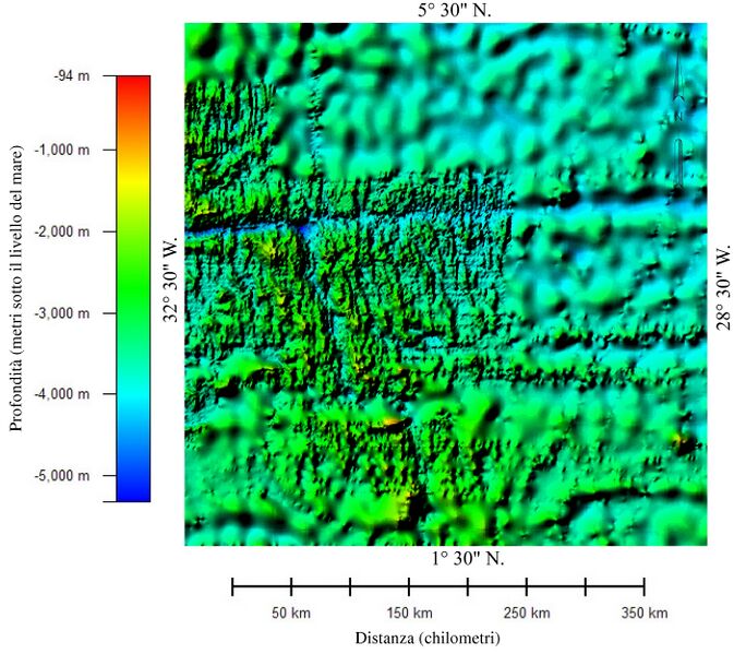
English: Color relief map of the bathymetry of the part of Atlantic Ocean in which Air France Flight 447 crashed. The image shows two different data sets with different resolution. The areas showing detailed bathymetry were mapped using multibeam bathmetry sonar. The areas showing very generalized bathmetry were mapped using high-density satellite altimetry.
|
| ⧼wm-license-information-date⧽ | 2015 |
| ⧼wm-license-information-source⧽ | ⧼Wm-license-own-work⧽ |
| ⧼wm-license-information-author⧽ | Adert |
| ⧼wm-license-information-other-versions⧽ |
ترخيص
تاريخ الملف
اضغط على زمن/تاريخ لرؤية الملف كما بدا في هذا الزمن.
| زمن/تاريخ | صورة مصغرة | الأبعاد | مستخدم | تعليق | |
|---|---|---|---|---|---|
| حالي | ★ مراجعة معتمدة 09:24، 14 نوفمبر 2023 | | 2٬808 × 2٬500 (3٫8 ميجابايت) | Pastakhov (نقاش | مساهمات) | Upload https://upload.wikimedia.org/wikipedia/commons/1/1a/AF447SeaBottom-it.jpg |
لا يمكنك استبدال هذا الملف.
وصلات
لا يوجد صفحات تصل لهذه الصورة.