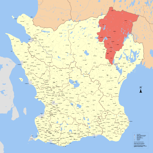
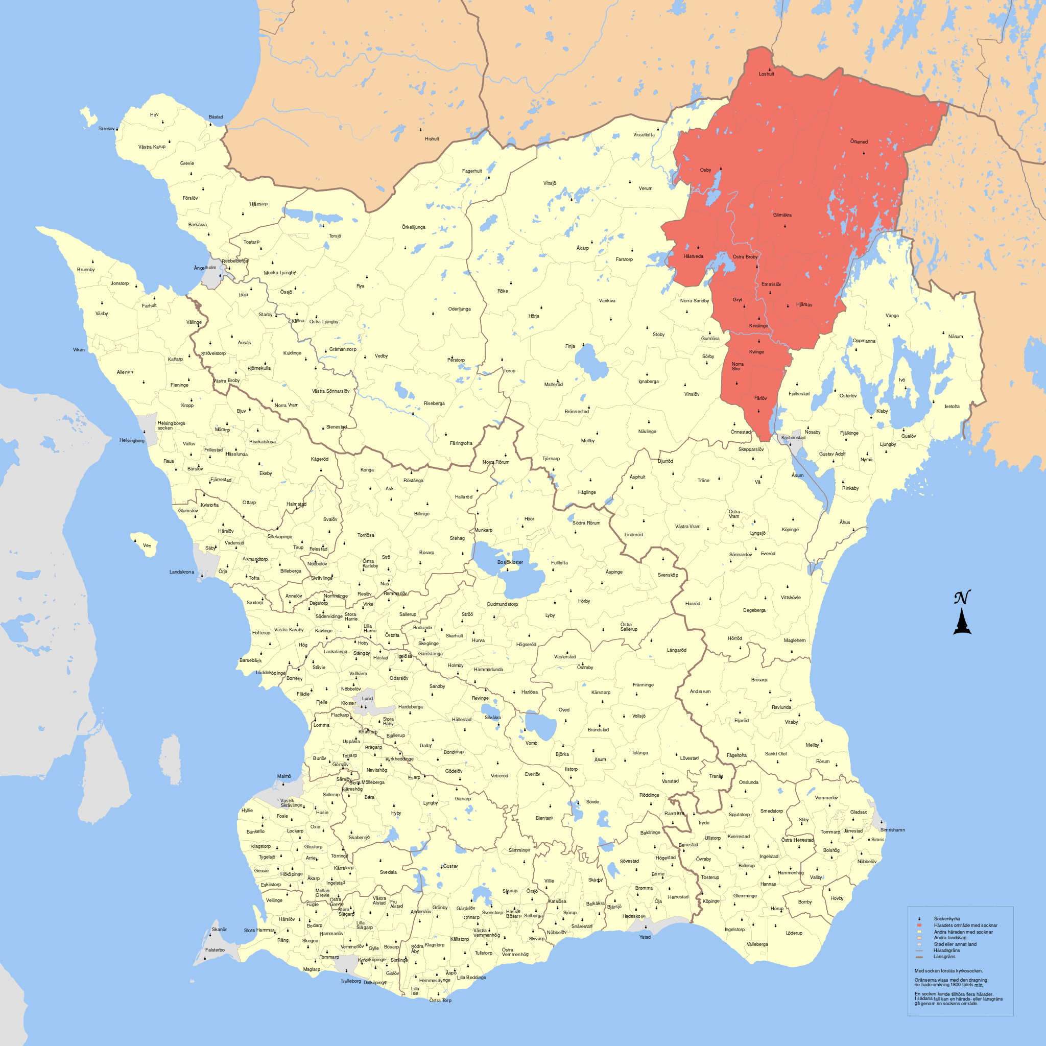
ملف:Östra Göinge härad.svg

حجم معاينة PNG لذلك الملف ذي الامتداد SVG: 600 × 600 بكسل. البعد الآخر: 2٬048 × 2٬048 بكسل.
الملف الأصلي (ملف SVG، أبعاده 14٬391 × 14٬391 بكسل، حجم الملف: 4٫1 ميجابايت)
| ⧼wm-license-information-description⧽ |
English: Map showing borders of parishes and hundreds in the vicinity of Hässleholm, based on information from map by Topografiska Corpsen. 9. Finja (Hässleholm) Grav. af C. Schleich. Topografiska Corpsens karta öfver Sverige 1865. Hallands länsdel öfversedd 1896.
English: Map showing borders of parishes and hundreds in the vicinity of Karlshamn, based on information from map by Topografiska Corpsen. Huseby (Vislanda) Grav. af C. Ebbesen Topografiska Corpsens karta öfver Sverige 1869. (Uppmätt 1863 och 1864.)
English: Map showing borders of parishes and hundreds in the vicinity of Karlshamn, based on information from map by Topografiska Corpsen. 10. Karlshamn Grav. af Ebbesen. Topografiska Corpsens karta öfver Sverige 1869. (Christianstads och Kronobergs ländelarne uppmätte 1862-63. Blekinge ländelen uppmätt 1843, öfversedd 1866.)
English: Map showing borders of parishes and hundreds in the vicinity of Kristianstad, based on information from map by Topografiska Corpsen. Kristianstad Grav. af C. Schleich Topografiska Corpsens karta öfver Sverige 1862.
English: Map showing borders of parishes and hundreds in the vicinity of Landskrona, based on information from map by Topografiska Corpsen. <smallLandskrona Grav. af G. Wirsing Topografiska Corpsens karta öfver Sverige 1860.
English: Map showing borders of parishes and hundreds in the vicinity of Lund, based on information from map by Topografiska Corpsen. Lund Holm, Kjöbenhamn Topografiska Corpsens karta öfver Sverige 1865.
English: Map showing borders of parishes and hundreds in the vicinity of Malmö, based on information from map by Topografiska Corpsen. Malmö Grav. af G. Wirsing Topografiska Corpsens karta öfver Sverige 1860
English: Map showing borders of parishes and hundreds in the vicinity of Simrishamn, based on information from map by Topografiska Corpsen. Simrishamn Graverad af L. Mattig Topografiska Corpsens Karta öfver Sverige 1861.
'English: Map showing borders of parishes and hundreds in the vicinity of Ystad, based on information from map by Topografiska Corpsen. Ystad Grav. af C.S. Wennersten. Topografiska Corpsens karta öfver Sverige 1864.
English: Map showing borders of parishes and hundreds in the vicinity of Ängelholm, based on information from map by Topografiska Corpsen. '3. Ängelholm Grav. af C. Schleich. Topografiska Corpsens karta öfver Sverige 1861. Hallands länsdel öfversedd 1895.
English: Map showing borders of parishes and hundreds in the vicinity of Halmstad, based on information from map by Topografiska Corpsen. Halmstad Grav af F.C. Holm Topografiska Corpsens karta öfver Sverige 1867.
English: Map showing borders of parishes and hundreds in the vicinity of Ljungby, based on information from map by Topografiska Corpsen. Ljungby topografiska Corpsens karta öfver Sverige 1870 (Kronobergs ländelen uppmått 1864, Hallands ländelen uppmätt 1842 och 1843, öfversedd 1865.)
|
| ⧼wm-license-information-date⧽ | 2010-10-01 19:08 (UTC) |
| ⧼wm-license-information-source⧽ | |
| ⧼wm-license-information-author⧽ |
|
| [This is a retouched picture, which means that it has been digitally altered from its original version. Modifications: combinde maps. The original can be viewed here: GS_Ljungby.svg. Modifications made by Edaen.] Error: {{Lang}}: text has italic markup (help)
|
|
|
هذا الملفُّ مُرخَّص بموجب رخصة المشاع الإبداعي نسبة المُصنَّف إِلى مؤلفه - المشاركة بالمثل 3.0 العامة. |
قالب:Original upload log
This image is a derivative work of the following images:
- File:GS_Finja.svg licensed with Cc-by-3.0
- 2010-09-25T08:17:03Z Edaen 5969x4438 (482094 Bytes) {{Information |Description={{en|1=Map showing borders of parishes and hundreds in the vicinity of Hässleholm, based on information from map by Topografiska Corpsen. '''9. Finja''' (Hässleholm) Grav. af C. Schleich. Topogr
- File:GS_Huseby.svg licensed with Cc-by-3.0
- 2010-09-30T16:49:14Z Edaen 5855x4434 (563496 Bytes) {{Information |Description={{en|1=Map showing borders of parishes and hundreds in the vicinity of Karlshamn, based on information from map by Topografiska Corpsen. '''Huseby''' (Vislanda) Grav. af C. Ebbesen Topografiska C
- File:GS_Karlshamn.svg licensed with Cc-by-3.0
- 2010-09-29T17:38:30Z Edaen 5930x4415 (751375 Bytes) {{Information |Description={{en|1=Map showing borders of parishes and hundreds in the vicinity of Karlshamn, based on information from map by Topografiska Corpsen. '''10. Karlshamn''' Grav. af Ebbesen. Topografiska Corpsen
- File:GS_Kristianstad.svg licensed with Cc-by-3.0
- 2010-09-28T21:07:27Z Edaen 5895x4462 (231511 Bytes) {{Information |Description={{en|1=Map showing borders of parishes and hundreds in the vicinity of Kristianstad, based on information from map by Topografiska Corpsen. '''Kristianstad''' Grav. af C. Schleich Topografiska Co
- File:GS_Landskrona.svg licensed with Cc-by-3.0
- 2010-09-26T16:27:44Z Edaen 5921x4408 (254754 Bytes) {{Information |Description={{en|1=Map showing borders of parishes and hundreds in the vicinity of Landskrona, based on information from map by Topografiska Corpsen.
- File:GS_Lund.svg licensed with Cc-by-3.0
- 2010-09-27T19:57:17Z Edaen 5825x4454 (558999 Bytes) "fit page to selection"
- 2010-09-27T19:55:48Z Edaen 744x1052 (584445 Bytes) {{Information |Description={{en|1=Map showing borders of parishes and hundreds in the vicinity of Ystad, based on information from map by Topografiska Corpsen. '''Lund''' Holm, Kjköbenhamn Topografiska Corpsens karta öfv
- File:GS_Malmö.svg licensed with Cc-by-3.0
- 2010-09-26T19:25:11Z Edaen 5989x4488 (96524 Bytes) {{Information |Description={{en|1=Map showing borders of parishes and hundreds in the vicinity of Malmö, based on information from map by Topografiska Corpsen. '''Malmö''' Grav. af G. Wirsing Topografiska Corpsens karta
- File:GS_Simrishamn.svg licensed with Cc-by-3.0
- 2010-09-28T13:51:52Z Edaen 5863x4457 (148704 Bytes) {{Information |Description={{en|1=Map showing borders of parishes and hundreds in the vicinity of Simrishamn, based on information from map by Topografiska Corpsen. '''Simrishamn''' Graverad af L. Mattig Topografiska Corps
- File:GS_Ystad.svg licensed with Cc-by-3.0
- 2010-09-27T13:44:30Z Edaen 5860x4543 (574672 Bytes) {{Information |Description={{en|1=Map showing borders of parishes and hundreds in the vicinity of Ystad, based on information from map by Topografiska Corpsen. ''Ystad''' Grav. af C.S. Wennersten. Topografiska Corpsens kar
- File:GS_Ängelholm.svg licensed with Cc-by-3.0
- 2010-09-25T08:20:16Z Edaen 6002x4547 (219668 Bytes) "fit page to selection"
- 2010-09-25T08:18:27Z Edaen 744x1052 (230572 Bytes) {{Information |Description={{en|1=Map showing borders of parishes and hundreds in the vicinity of Ängelholm, based on information from map by Topografiska Corpsen. ''''''3. Ängelholm''' Grav. af C. Schleich. Topografiska
- File:GS_Halmstad.svg licensed with Cc-by-3.0
- 2010-09-23T08:00:37Z Edaen 5973x4465 (198993 Bytes) {{Information |other_versions={{DerivativeVersions|Bohuslän landskap härader socknar.svg}} Halmstad, based on information from map by Topografiska Corpsen. '''Halmstad''' Grav af F.C. Holm Topografiska Corpsens karta ö
- File:GS_Ljungby.svg licensed with Cc-by-3.0
- 2010-09-22T16:15:45Z Edaen 5946x4463 (397615 Bytes) "fit page to selection"
- 2010-09-22T16:13:39Z Edaen 744x1052 (404595 Bytes) {{Information |other_versions={{DerivativeVersions|Bohuslän landskap härader socknar.svg}} |Description={{en|1=Map showing borders of parishes and hundreds in the vicinity of Ljungby, based on information from map by Topog
تاريخ الملف
اضغط على زمن/تاريخ لرؤية الملف كما بدا في هذا الزمن.
| زمن/تاريخ | صورة مصغرة | الأبعاد | مستخدم | تعليق | |
|---|---|---|---|---|---|
| حالي | ★ مراجعة معتمدة 04:02، 15 يناير 2024 | | 14٬391 × 14٬391 (4٫1 ميجابايت) | Pastakhov (نقاش | مساهمات) | Upload https://upload.wikimedia.org/wikipedia/commons/8/85/%C3%96stra_G%C3%B6inge_h%C3%A4rad.svg |
لا يمكنك استبدال هذا الملف.
وصلات
لا يوجد صفحات تصل لهذه الصورة.