منطقة توهكو
Tōhoku region
東北地方 | |
|---|---|
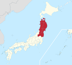
 Tōhoku region in Japan | |
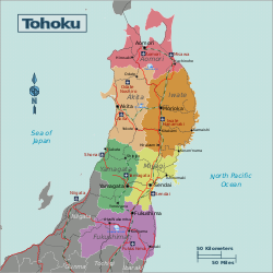
 Prefectures and major cities in Tōhoku | |
| المساحة | |
| • الإجمالي | 66٬951٫97 كم² (25٬850٫30 ميل²) |
| التعداد (June 1, 2019) | |
| • الإجمالي | 8٬682٬011 |
| • الكثافة | 130/km2 (340/sq mi) |
| منطقة التوقيت | UTC+09:00 (JST) |
منطقة توهكو 東北地方 توهكو تشيهو هي أحد المناطق الجغرافية في اليابان. تعني كلمة "توهكو" الشمال الشرقي، حيث أن تلك المنطقة تحتل الشمال الشرقي من جزيرة هونشو أكبر جزر اليابان. يبلغ تعداد سكان المنطقة 9,326,926 نسمة في 1 يناير 2011، بكثافة 139.4 نسمة / كم2.
المحافظات
تضم المنطقة ست محافظات هي:
وتعتبر مدينة سنداي أكبر مدن المنطقة.
الديمغرافيا
| Year | Pop. | ±% |
|---|---|---|
| 1884 | 3٬957٬085 | — |
| 1898 | 4٬893٬747 | +23.7% |
| 1920 | 5٬793٬974 | +18.4% |
| 1940 | 7٬164٬674 | +23.7% |
| 1950 | 9٬021٬809 | +25.9% |
| 1955 | 9٬334٬442 | +3.5% |
| 1970 | 9٬031٬197 | −3.2% |
| 1975 | 9٬232٬875 | +2.2% |
| 1980 | 9٬572٬088 | +3.7% |
| 1985 | 9٬730٬352 | +1.7% |
| 1990 | 9٬738٬284 | +0.1% |
| 1995 | 9٬834٬124 | +1.0% |
| 2000 | 9٬817٬589 | −0.2% |
| 2010 | 9٬335٬636 | −4.9% |
| 2018 | 8٬768٬559 | −6.1% |
| ملاحظة: All figures since 1920 are October, except 2018 which is Apr. Source: Japan Census figures except latest which from ja:東北地方 | ||
The population decline of Tōhoku, which began before the year 2000, has accelerated, now including previously dynamic Miyagi. Despite this, Sendai City has grown, in part due to relocations of people affected by the 2011 disaster. The population decline of Aomori, Iwate and Akita Prefectures, Honshu's three northernmost, began in the early 1980s after an initial loss of population in the late 1950s. Fukushima Prefecture, prior to 1980, had traditionally been the most populated, but today Miyagi is the most populated and urban by far.
أهم المعالم
المدن والمناطق المأهولة بالسكان |
المعالم الطبيعية
متنزهات
|
انظر أيضاً
المصادر
- This article contains material from the Library of Congress Country Studies, which are United States government publications in the public domain.—Japan
- [1]
- [2]
وصلات خارجية
- Tōhoku region travel guide from Wikitravel
- Akita Prefecture Official website (إنگليزية)
- Aomori Prefecture Official website
- Fukushima Prefecture Official website (إنگليزية)
- Miyagi Prefecture Official website (إنگليزية)
- Yamagata Prefecture Official website (إنگليزية)
- Iwate Prefecture Living Guide for Foreign Nationals (إنگليزية)
- Pages using gadget WikiMiniAtlas
- Short description is different from Wikidata
- Articles with hatnote templates targeting a nonexistent page
- Missing redirects
- Pages using infobox settlement with missing country
- Pages using infobox settlement with image map1 but not image map
- Pages using infobox settlement with no coordinates
- مقالات تحتوي نصاً باللغة اليابانية
- Coordinates on Wikidata
- منطقة توهكو
- زلزال وتسونامي سنداي 2011
- مناطق اليابان

