ميناء جاكسون
| ميناء جاكسون Port Jackson | |
|---|---|
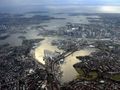
_V2.jpg&filetimestamp=20140905220750&) ميناء جاكسون من الجو في 2006 | |
 ميناء جاكسون Port Jackson | |
| الموقع | Sydney, New South Wales, Australia |
| الإحداثيات | 33°51′30″S 151°14′00″E / 33.85833°S 151.23333°E |
| منابع النهر | پاراماتا، لان كوپ، ميدل هاربر |
| منابع المحيط/البحر | بحر تاسمانيا، المحيط الهادي الجنوبي |
| بلدان الحوض | أستراليا |
| الجزر | كلارك، شارك، گوت، فورت دينشن |
| التجمعات السكنية | سيدني |
ميناء جاكسون Port Jackson، يسمى أيضاً ميناء سيدني، هو مرفأ طبيعي في سيدني، نيوساوث ويلز، أستراليا. المرفأ هو مدخل لبحر تسمانيا (جزء من المحيط الهادي الجنوبي). يعتبر واحدأً من أفضل الموانئ[بحاجة لمصدر]، ويقع فيه دار اوپرا سيدني وجسر ميناء سيدني. كموقع لأقدم مستوطنة أوروپية في أستراليا، استمر ميناء جاكسون في لعب دوراً محورياً في تاريخ وتطور سيدني.
Port Jackson, in the early days of the colony, was also used as a shorthand for Sydney and its environs. Thus, many botanists, see, e.g., Robert Brown's Prodromus Florae Novae Hollandiae et Insulae Van Diemen,[1] described their specimens as having been collected at Port Jackson.
تقام العديد من الأنشطة الترفيهية على وحول النياء وخاصة احتفالات راس السنة الجديدة في سيدني وينطلق منه سباق يخوت سيدني - هوبارت.[2]
الممرات المائية في ميناء جاكسون تحت إدارة خدمات الطرق والبحرية بنيوساوث ويلز. يحمي المنتزه الوطني بميناء سيدني عدد من الجزر والمناطق البحرية، مناطق السباحة، مسارات المشي في الأحراج، ومناطق التنزه.[3] The harbour is a global hotspot for marine and estuarine diversity.[4]
التاريخ


At the time of the European arrival and colonisation, the land around Port Jackson was inhabited by the Eora clans, including the Gadigal, Cammeraygal, and Wangal. The Gadigal inhabited the land stretching along the south side of Port Jackson from what is now South Head, in an arc west to the present Darling Harbour. The Cammeraygal lived on the northern side of the harbour. The area along the southern banks of the Parramatta River to Rose Hill belonged to the Wangal. The Eora inhabited Port Jackson (Sydney Harbour), south to the Georges River and west to Parramatta.[5]
Cook's naming of Port Jackson
The first recorded European discovery of Sydney Harbour was by Lieutenant James Cook in 1770. Cook named the inlet after Sir George Jackson, one of the Lords Commissioners of the British Admiralty, and Judge Advocate of the Fleet.[6] As the Endeavour sailed past the entrance at Sydney Heads, Cook wrote in his journal "at noon we were...about 2 or 3 miles from the land and abrest of a bay or harbour within there appeared to be a safe anchorage which I called Port Jackson."
First Fleet
Eighteen years later, Port Jackson saw the arrival of the First Fleet. On 21 January 1788, after arriving at Botany Bay, Governor Arthur Phillip took a longboat and two cutters up the coast to sound the entrance and examine Cook's Port Jackson. Phillip first stayed overnight at Camp Cove, just inside the South Head, then moved up the harbour, landing at Sydney Cove and then Manly Cove, before returning to Botany Bay on the afternoon of 24 January. Phillip returned to Sydney Cove in HM Armed Tender Supply on 26 January 1788, where he established the first colony in Australia, later to become the city of Sydney. In his first dispatch from the colony back to England, Governor Phillip noted that:[7][8]
We got into Port Jackson early in the Afternoon, and had the satisfaction of finding the finest Harbour in the World, in which a thousand Sail of the line may ride in the most perfect security...I fixed on the one [cove] that had the best spring of Water, and in which the Ships can Anchor so close to the Shore, that at a very small expence...
— Governor Arthur Phillip, 15 May 1788.
Port Jackson was described as a "capacious harbour, equal, if not superior to any yet known in the world", that "sheltered anchorage for the ships" and provided "a suitable landing place on rocks on the western side of the cove, relatively level land at the head of the cove, and a run of fresh water", in addition to it being "capable of affording security to a much larger fleet than would probably ever seek for shelter or security in it." Royal Navy officer David Blackburn also described it as a "fine Harbour as Any in the World, with water for any Number of the Largest ships."[7]
Later events
The Great White Fleet, the United States Navy battle fleet, arrived in Port Jackson in August 1908 by order of U.S. President Theodore Roosevelt. From 1938, seaplanes landed in Sydney Harbour on Rose Bay, making this Sydney's first international airport.
معركة ميناء سيدني

In 1942, to protect Sydney Harbour from a submarine attack, the Sydney Harbour anti-submarine boom net was constructed. It spanned the harbour from Green (Laings) Point, Watsons Bay to the battery at Georges Head, on the other side of the harbour. On the night of 31 May 1942, three Japanese midget submarines entered the harbour, one of which became entangled in the western end of the boom net's central section. Unable to free their submarine, the crew detonated charges, killing themselves in the process. A second midget submarine came to grief in Taylor's Bay, the two crew committing suicide. The third submarine fired two torpedoes at USS Chicago (both missed) before leaving the harbour. In November 2006, this submarine was found off Sydney's Northern Beaches.[9]
The anti-submarine boom net was demolished soon after World War II, and all that remains are the foundations of the old boom net winch house, which can be viewed on Green (Laings) Point, Watsons Bay. Today, the Australian War Memorial has on display a composite of the two midget submarines salvaged from Sydney Harbour.[10][11] The conning tower of one of the midget submarines is on display at the RAN Heritage Centre, Garden Island, Sydney.[12]
التحصينات
Fort Denison is a former penal site and defensive facility occupying a small island located north-east of the Royal Botanic Garden in Sydney Harbour.
There are fortifications at Sydney Heads and elsewhere, some of which are now heritage listed. The earliest date from the 1830s, and were designed to defend Sydney from seaborn attack or convict uprisings. There are four historical fortifications located between Taronga Zoo and Middle Head, Mosman, they are: the Middle Head Fortifications, the Georges Head Battery, the Lower Georges Heights Commanding Position and a small fort located on Bradleys Head, known as the Bradleys Head Fortification Complex. The forts were built from sandstone quarried on site and consist of various tunnels, underground rooms, open batteries and casemated batteries, shell rooms, gunpowder magazines, barracks and trenches.[13][14]
الجغرافيا


Geologically, Port Jackson is a drowned river valley, or ria. It is 19 km long with an area of 55 km2. The estuary's volume at high tide is 562 million cubic metres. The perimeter of the estuary is 317 kilometres.
According to the Geographical Names Board of New South Wales, Port Jackson is "a harbour which comprises all the waters within an imaginary line joining North Head and South Head. Within this harbour lies North Harbour, Middle Harbour and Sydney Harbour."[15]
Port Jackson extends westward from the single entrance known as Sydney Heads (North and South Heads) and encompasses all tidal waters within North Harbour, Middle Harbour, Sydney Harbour, Darling Harbour, Parramatta River and Lane Cove River.[16]
The harbour is heavily embayed. The bays on the south side tend to be wide and rounded, whereas those on the north side are generally narrow inlets. Many of these bays include beaches. The Sydney central business district extends from Circular Quay.

Headlands and peninsulas
East to west, north side:
- North Head
- Dobroyd Head
- Middle Head
- Georges Head
- Bradleys Head
- Cremorne Point
- Kurraba Point
- Kirribilli
- McMahons Point
- Balls Head
- Berry Island
East to west, south side
- South Head
- Point Piper
- Darling Point
- Potts Point
- Bennelong Point
- Dawes Point
- Millers Point
- Pyrmont
- Balmain

الجزر
There are several islands within the harbour, including Shark Island, Clark Island, Fort Denison, Goat Island, Cockatoo Island, Spectacle Island, Snapper Island and Rodd Island. Some other former islands, including Garden Island, Glebe Island and Berry Island, have been linked to the shore by land reclamation, though their names often still contain the word "island". Two other former islands, Bennelong Island and Darling Island, are similarly now linked to the mainland, but rarely mentioned as islands. The former Dawes Island was joined to another small island to create Spectacle Island.[17] Exposed at low tide is Sow and Pigs Reef, a well-known navigation obstacle near the main shipping lane.
الروافد والممرات المائية
- Tank Stream was a freshwater course emptying into Sydney Cove. Today it is little more than a stormwater drain but originally it was the fresh water supply for the fledgling colony of New South Wales. It originated from a swamp to the west of present-day Hyde Park and at high tide entered Sydney Cove at the intersection of Bridge and Pitt Streets.
- Middle Harbour is the northern arm of Port Jackson. It begins as a small creek (Middle Harbour Creek) at St Ives.[18] It joins the main waterway between two headlands, Middle Head and Grotto Point Reserve, west of Sydney Heads.
- Parramatta River is the western arm of Port Jackson. The river begins at the confluence of Toongabbie Creek and Darling Mills Creek west of Parramatta and joins the main waterway between Greenwich Point, Greenwich, and Robinsons Point, Birchgrove.[19]
- Lane Cove River rises near Thornleigh and flows generally south for about 15 kilometres (9.3 mi). Its catchment area is approximately 95.4 square kilometres (36.8 sq mi).
- Tarban Creek, a northern tributary of the Parramatta River, enters Port Jackson at Hunters Hill.
- Johnstons Creek rises in Stanmore and flows in a generally northward direction, passing through the inner-western suburbs of Forest Lodge, Annandale and Glebe. The creek passes beneath the stands of the now demolished Harold Park Paceway prior to emptying into Rozelle Bay at Bicentennial Park, Glebe. Orphan School Creek is a tributary.
- Duck River is a perennial stream and southern tributary of the Parramatta River.
Climate

Port Jackson has a humid subtropical climate (Köppen: Cfa) with warm, somewhat humid summers and mild to cool winters, with moderate rainfall spread throughout the year. Due to its exposed proximity to the Tasman Sea, it is slightly cooler, wetter and windier than Observatory Hill to the west. In addition to featuring the lowest maximum summer temperatures in the Sydney region (averaging just 24.4 °C (75.9 °F)), Port Jackson is also least affected by extreme heat due to frequent sea breezes. Conversely, winter nights are among the warmest in Sydney, and rarely dip below 8.0 °C (46.4 °F), although fog often occurs and may be disruptive.
Port Jackson's weather station is located within a lighthouse just south of Georges Head at Georges Heights in Mosman and is adjacent to the suburbs of Vaucluse, Point Piper and Watsons Bay, which are on Port Jackson's east side towards the Pacific Ocean. Sydney Cove, a bay in Port Jackson's west side that includes Circular Quay, is more proximate to the Observatory Hill weather station, and therefore the climate data below does not apply to that vicinity.
| بيانات المناخ لـ Sydney Harbour (Western Channel Pile Light) | |||||||||||||
|---|---|---|---|---|---|---|---|---|---|---|---|---|---|
| الشهر | ينا | فب | مار | أبر | ماي | يون | يول | أغس | سبت | أكت | نوف | ديس | السنة |
| القصوى القياسية °س (°ف) | 42.2 (108.0) |
39.4 (102.9) |
38.2 (100.8) |
32.4 (90.3) |
27.0 (80.6) |
24.1 (75.4) |
25.2 (77.4) |
28.7 (83.7) |
34.1 (93.4) |
35.8 (96.4) |
40.8 (105.4) |
38.5 (101.3) |
42.2 (108.0) |
| متوسط القصوى اليومية °س (°ف) | 24.8 (76.6) |
24.8 (76.6) |
23.9 (75.0) |
22.4 (72.3) |
20.0 (68.0) |
17.8 (64.0) |
17.3 (63.1) |
17.9 (64.2) |
19.8 (67.6) |
21.2 (70.2) |
22.2 (72.0) |
23.6 (74.5) |
21.3 (70.3) |
| المتوسط اليومي °س (°ف) | 22.6 (72.7) |
22.7 (72.9) |
21.6 (70.9) |
19.6 (67.3) |
16.8 (62.2) |
14.7 (58.5) |
13.9 (57.0) |
14.5 (58.1) |
16.6 (61.9) |
18.3 (64.9) |
19.7 (67.5) |
21.3 (70.3) |
18.5 (65.3) |
| متوسط الدنيا اليومية °س (°ف) | 20.4 (68.7) |
20.6 (69.1) |
19.3 (66.7) |
16.8 (62.2) |
13.5 (56.3) |
11.6 (52.9) |
10.5 (50.9) |
11.1 (52.0) |
13.4 (56.1) |
15.4 (59.7) |
17.2 (63.0) |
18.9 (66.0) |
15.7 (60.3) |
| الصغرى القياسية °س (°ف) | 14.8 (58.6) |
14.7 (58.5) |
13.2 (55.8) |
10.7 (51.3) |
8.9 (48.0) |
5.0 (41.0) |
6.1 (43.0) |
6.2 (43.2) |
7.0 (44.6) |
8.8 (47.8) |
11.0 (51.8) |
12.1 (53.8) |
5.0 (41.0) |
| متوسط تساقط الأمطار mm (inches) | 97.6 (3.84) |
120.6 (4.75) |
120.7 (4.75) |
136.4 (5.37) |
122.5 (4.82) |
138.4 (5.45) |
96.1 (3.78) |
81.3 (3.20) |
70.9 (2.79) |
73.7 (2.90) |
89.2 (3.51) |
78.4 (3.09) |
1٬215٫8 (47.87) |
| Average precipitation days (≥ 1 mm) | 8.3 | 8.4 | 9.3 | 10.1 | 9.1 | 9.4 | 7.5 | 8.1 | 7.9 | 8.5 | 8.4 | 8.2 | 103.2 |
| Source 1: Bureau of Meteorology (temperatures, 1996–present)[20] | |||||||||||||
| Source 2: Bureau of Meteorology, Rose Bay (rainfall, 1928–present)[21] Manly Town Hall (rain days, 1914–1963)[22] | |||||||||||||
البنية التحتية

الجسور

Port Jackson is bridged from north to south by the Sydney Harbour Bridge, the Gladesville Bridge, the Ryde Bridge, and the Silverwater Bridge.
Other bridges spanning Port Jackson waterways are Pyrmont Bridge spanning Darling Harbour; the Anzac Bridge (formerly known as the Glebe Island Bridge), spanning Blackwattle Bay; the Iron Cove Bridge spanning Iron Cove; the Spit Bridge spanning Middle Harbour; the Roseville Bridge spanning Middle Harbour; the Tarban Creek Bridge spanning Tarban Creek.
The original Meadowbank Railway Bridge carried the Main Northern railway line, now reduced to pedestrian traffic only. The replacement John Whitton Bridge carries two railway tracks with piers suitable for four tracks.
There is a single track rail bridge on the Carlingford railway line crossing the Parramatta River near Camellia.
Bennelong Bridge over Homebush Bay connects Wentworth Point and Rhodes
الأنفاق
محطات السفن السياحية

مرافق أخرى في الميناء
النقل البحري

التراث البحري

وحدة القياس المشتقة
معرض الصور

The QE2 docked at Sydney Harbour, looking towards Circular Quay and the Sydney CBD.
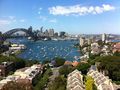
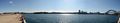
View of Port Jackson and Sydney's CBD.
ميناء سيدني.
Sydney Harbour and Port Jackson displaying aerial views of the Sydney Harbour Bridge and the Sydney Opera House. The CBD is located to the far left of the photo.
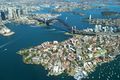
Port Jackson, as seen from Rose Bay.
This is the view of Sydney Harbour from Millers Point.
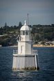
Sow and Pigs Reef Danger Marker in Sydney Harbour.


_03.jpg&filetimestamp=20140905224642&)

انظر أيضاً
المصادر
- ^ Brown, Robert. Prodromus floræ Novæ Hollandiæ et Insulæ Van-Diemen : exhibens characteres plantarum quas annis 1802–1805 /. Londini: typis R. Taylor et socii.
- ^ "Rolex Sydney Hobart Yacht Race 2024". rolexsydneyhobart.com. Retrieved 2024-06-27.
- ^ "Sydney Harbour National Park". NSW National Parks.
- ^ Mayer-Pinto, M.; Johnston, E. L.; Hutchings, P. A.; Marzinelli, E. M.; Ahyong, S. T.; Birch, G.; Booth, D. J.; Creese, R. G.; Doblin, M. A.; Figueira, W.; Gribben, P. E.; Pritchard, T.; Roughan, Steinberg; Steinberg, P. D.; Hedge, L. H. (2015). "Sydney Harbour: a review of anthropogenic impacts on the biodiversity and ecosystem function of one of the world's largest natural harbours" (PDF). Marine and Freshwater Research. 66: 1088–1105. doi:10.1071/MF15157. Retrieved 10 February 2024.
- ^ Woollarawarre Bennelong quoted by Governor Arthur Phillip in a despatch to Lord Sydney, 13 February 1790 CO201/5, National Archives, Kew (London)
- ^ McDermott, Peter Joseph (6 November 1878). "Pacific Exploration". The Brisbane Courier. Brisbane Newspaper Company Ltd. p. 5. Retrieved 5 November 2008.
- ^ أ ب Champion, Shelagh; Champion, George (1990). "Phillip's First Three Days in Port Jackson: 21st, 22nd and 23rd January 1788". Manly, Warringah and Pittwater: First Fleet Records of Events, 1788–1790 (September 2005 revised ed.). Killarney Heights: Shelagh and George Champion. ISBN 0-9596484-3-7. Archived from the original (PDF) on 10 July 2017.
- ^ "Letter from Governor Phillip to Lord Sydney (15 May 1788)". Historical Records of New South Wales Vol 1, Part 2 (1783–1792). Charles Potter, Government Printer. 1892. p. 122.
- ^ Office of Environment and Heritage. "M24 Japanese Midget Submarine wreck site". State Heritage Inventory Database. Retrieved 28 October 2018.
- ^ NPWS plaque
- ^ Grose, Peter (2007). A Very Rude Awakening: The night the Japanese midget subs came to Sydney Harbour. Allen & Unwin. ISBN 9781741752199.
- ^ "DECC – Defence heritage in and around Sydney Harbour". Archived from the original on 31 December 2007. Retrieved 1 December 2007.
- ^ "heritage.nsw.gov.au".
- ^ قالب:NSW GNR
- ^ RAN Hydrographic Services Map of Port Jackson published in August 1972.
- ^ "The Sydney Harbour Islands" (PDF). Archived from the original (PDF) on Aug 14, 2021.
- ^ UBD Citylink Street Directory Page 155 Map reference F4
- ^ UBD City Link Street Directory Page191 Map Reference A12
- ^ "Climate statistics for Sydney Harbour (Wedding Cake West) (1996–present)". Bureau of Meteorology. Retrieved 29 October 2020.
- ^ "Climate statistics for Rose Bay (Royal Sydney Golf Club)". Bureau of Meteorology. Retrieved 29 October 2020.
- ^ "BOM – Manly". May 2020.
وصلات خارجية
- ABC Radio National: "A Living Harbour" — a history of Sydney Harbour.
- Official New South Wales Maritime Authority website
- Maps maintained by the New South Wales Maritime Authority (legal owner of the harbour bed):
- "Sydney Harbour and Parramatta River catchment" (map). Office of Environment and Heritage. Government of New South Wales.
- Sydney Harbour Federation Trust — established by the Australian Government to plan for the future of former Defence and other special Commonwealth Lands around Sydney Harbour.
- Sydney Ports
| الفعاليات |  | ||||
|---|---|---|---|---|---|
| Venues |
| ||||
| متعلقة |
| ||||

_V2.jpg&filetimestamp=20140905220750)
- Pages using gadget WikiMiniAtlas
- CS1: Julian–Gregorian uncertainty
- Articles with hatnote templates targeting a nonexistent page
- Short description is different from Wikidata
- Coordinates on Wikidata
- Articles with unsourced statements from August 2014
- ميناء سيدني
- خلجان نيوساوث ويلز
- موانئ نيوساوث ويلز
- جغرافيا سيدني
- رأس السنة الجديدة في سيدني
- معالم سياحية في سيدني