سمتسخى-جڤاختي
سامتسخه-جڤاختي
სამცხე-ჯავახეთი | |
|---|---|
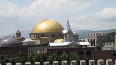
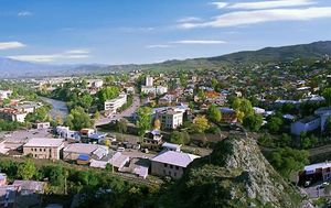
من أعلى إلى أسفل اليمين: قلعة أخالتسيخه، منتزه بورجومي المركزي، Kartsakhi Managed Reserve، دير تيموتسوباني، ڤاردزيا | |
 | |
| البلد | |
| المقر | أخالتسيخه |
| التقسيمات | 6 بلديات |
| الحكومة | |
| • الحاكم | Lasha Chkadua |
| المساحة | |
| • الإجمالي | 6٬413 كم² (2٬476 ميل²) |
| التعداد (تعداد 2014) | |
| • الإجمالي | 160٬262 |
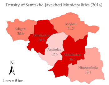
| • الكثافة | 25/km2 (65/sq mi) |
| ISO 3166 code | GE-SJ |
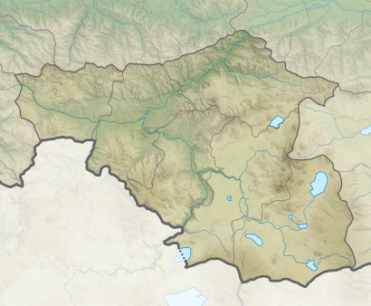
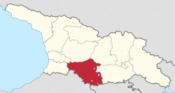
سامتسخه-جڤاختي (بالجورجية: სამცხე-ჯავახეთი؛ إنگليزية: Samtskhe-Javakheti)، هي منطقة (بالجورجية: مخارى) تشكلت في عقد 1990 في جنوب جورجيا من المقاطعات التاريخية مسختي (سامتسخه)، جڤاختي وتوري (مضيق بورجومي). أخالتسيخه هي العاصمة. وتتكون المنطقة من ست مقاطعات ادارية: أخالتسيخه، أديگني، أسپيندزا، بورجومي، أخالكلكي ونينوتسميندا. ويجد خمس بلدات، وست بلديات، و67 تجمع وقرية sakrebulos (assemblies)، و268 قرية في المنطقة.
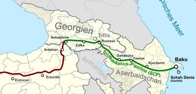
خط أنابيب باكو-تفليس-جيحان النفطي، وخط أنابيب جنوب القوقاز الغازي، وسكة حديد قارص-تفليس-باكو (قيد الإنشاء) يمرون عبر المنطقة.
الجغرافيا
سامتسخه-جڤاختي تحدها مناطق آجارا إلى الغرب، گوريا وإيمرتي إلى الشمال، شيدا قرتلي وكڤمو قرتلي إلى الشمال الشرقي وإلى الشرق، وأرمينيا وتركيا إلى الجنوب والجنوب الغربي.
تبلغ مساحة المنطقة 6413 كم² ويسكنها 160.262 نسمة. المركز الاداري للمنطقة هي أخالتسيخه. وتضم 353 منطقة مأهولة، تشمل:
- المدن: أخالتسيخه، أخالكلكي، بورجومي، ڤال، ونينوتسميندا.
- 7 "دابا": باكورياني، بكاوريانيس أندزيتي، تساگڤري، أخالدابا، أديگني، أباستوماني، أسپيندزا.
- 259 قرية
التاريخ
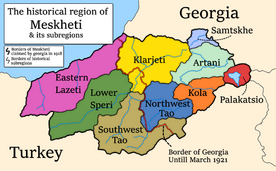
The current division of Georgia into "regions" (Mkhare) was introduced by the Shevardnadze government in the mid-1990s, partly as a response to the secession of Abkhazia and the South Ossetia conflict. Samtskhe–Javakheti was basically formed by combining the two traditional provinces of Meskheti (Samtskhe) and Javakheti.
مسختي
The ancient tribes of Meskhi (or Moschi) and Mosiniks are the first known inhabitants of the area. Some scholars credit the Mosiniks (or Mossynoeci) with the invention of iron metallurgy. From the 2nd millennium to the 4th century BC, Meskheti was believed to be part of the Kingdom of Diauehi, in the 4th century BC to the 6th century AD part of the Kingdom of Iberia. From the 10th to the 15th century it was part of the united Georgian Kingdom. In the 16th century Meskheti was integrated into the Safavid Empire, followed by the Ottoman Empire. After the conclusion of the Russo-Persian War of 1826-28, it was a part of Russian Tiflis Governorate from 1817 till 1829, from 1918 to 1921 part of the Democratic Republic of Georgia, and from 1921 to 1990 part of the Georgian SSR. After independence from the USSR Meskheti was reinstalled as a province of Georgia, and later cast into the new Samtskhe–Javakheti region.
جڤاختي
In ancient sources, the region was recorded as Zabakha in 785 BC, by the king Argishti I of Urartu. According to Cyril Toumanoff, Javakheti was part of the Iberian duchy of Tsunda from the 4th or 3rd century BC. Saint Nino entered Iberia from Javakheti, and, following the course of the River Kura, she arrived in Mtskheta, the capital of the kingdom, once there, she eventually began to preach Christianity, which culminated by Christianization of Iberia.
In struggle against the Arab occupation, Bagrationi dynasty came to rule over Tao-Klarjeti and established the Kouropalatate of Iberia. rulers of Tao-Klarjeti fought the Arabs from there, gradually incorporating the surrounding lands of Samtskhe and Javakheti, along with a few other lesser lands, from the Arab dominance. For a long time the region became a cultural safe-house and one of the most important religious centers of Georgia.
In the mid-10th century, Javakheti was incorporated into Kingdom of Abkhazia. In 964 Leon III of Abkhazia extended his influence to Javakheti, during his reign was built Kumurdo Cathedral.[1][2] In subsequent centuries, Javakheti was integral part of unified Georgian monarchy and had a period of significant development: lot of bridges, churches, monasteries, and royal residences (Lgivi, Ghrtila, Bozhano, Vardzia) were built. From the 11th century, the center of upper Javakheti became Akhalkalaki. From the 10th century, the center of lowland Javakheti was Tmogvi. From the 12th century, the domain was ruled by representatives of the feudal family of Toreli.
In the 15th century, Javakheti was incorporated to principality of Samtskhe-Saatabago. In the 16th century, the region, as well as the adjacent territories of western Georgia, was occupied by the Ottoman Empire. The Georgian population of Javakheti was displaced to inner regions of Georgia such as Imereti and Kartli. Those who remained gradually became Muslim.
As a result of the struggles of the Russian Empire with the Ottomans, Russian authorities settled Christian Armenians and Caucasus Greeks in the area after 1828.[3] Armenian refugees from the Armenian genocide in the Ottoman Empire came in the early 20th century. Also a large number of Russian Doukhobor sect members settled the region.
العهد السوڤيتي
Georgia came fully under Soviet control in 1921, after the Red Army invasion of Georgia. The remaining Muslim minority in Meskheti, also known as "Meskhetian Turks", were deported in cattle-trucks to Central Asia by order of Stalin and settled within an area that overlaps the boundaries of the modern nations of Kazakhstan, Kyrgyzstan, and Uzbekistan. Today, many are still dispersed across those countries. Of the 100,000 forcibly deported, as many as 30,000-50,000 perished.[4]
الوضع الحالي
في أغسطس 2019، إثر تصريح رئيس الوزراء الأرمني نيكول پاشينيان بأن أرتساخ (ناگورنو قرة باخ) جزء لا يتجزأ من أرمينيا، تصاعدت الروح الانفصالية لدى الأرمن في سمتسخى-جڤاختي بجنوب جورجيا. ويصاحب ذلك تأييد متزايد من داخل أرمينيا. وكان الرئيس پاشينيان قد زار منطقة جڤاختي في شهر مايو الماضي.
ويشكل الأرمن أغلبية في تلك المقاطعة الجورجية. أهمية المنطقة تنبع من مرور خط أنابيب الغاز العابر للأناضول (TANAP) الذي ينقل الغاز من أذربيجان عبر جورجيا وتركيا إلى أوروبا. ويعارض السكان الأرمن في ذلك الإقليم الجورجي مرور خط الأنابيب الأذربيجاني. مما يوحي بدعم روسي للأرمن.[5]
التقسيمات الادارية
تتألف المنطقة من ستة بلديات:
| البلدية/المدينة | السكان | البلدية/القرية | السكان |
|---|---|---|---|
| أخالتسيخه | 20,992 | أخالتسيخه | 17.903 |
| أديگني | 16.462 | أديگني | 783 |
| أسپيندزا | 10.372 | أسپيندزا | 2.793 |
| بورجومي | 25.214 | بورجومي | 10.546 |
| أخالكلكي | 21.127 | أخالكلكي | 8.295 |
| نينوتسميندا | 45.070 | نينوتسميندا | 5.144 |
الديموغرافيا
في 2017، كانت الجماعات العرقية التالية في سمتسخى-جڤاختي تشكل 160.504 نسمة:[6]
- الأرمن - 81.089 (50.52%)
- الجورجيون - 77.498 (48.28%)
- الروس - 712 (0.44%)
- جماعات عرقية أخرى - 1.194 (0.74%)
المعالم السياحية
The major tourist attractions are the cave monasteries of Vardzia (which was founded by Queen Tamar in 1185), Vanis Kvabebi (which dates from the 8th century), Rabati Castle and Khertvisi Fortress. Also, among national visitors is very popular 10th century Sapara Monastery, Tmogvi fortress, and 8th century Zarzma monastery.[7]
انظر أيضاً
الهوامش
- ^ "Kumurdo Church". Georgian patriarchate, Eparchy of Shemoqmedi. Archived from the original on 21 July 2011. Retrieved 5 March 2011.
- ^ "Kumurdo". Parliament of Georgia. Retrieved 5 March 2011.
- ^ Boeschoten, Hendrik; Rentzsch, Julian (2010). Turcology in Mainz. p. 142. ISBN 978-3-447-06113-1. Retrieved 9 July 2011.
- ^ Dan Brennan (5 Apr 2003). "Guram Mamulia". The Guardian. Retrieved 29 Apr 2008.
- ^ Paul Goble (2019-08-08). "Is Georgia's Javakhetia Region on the Brink of Explosion?". مؤسسة جيمستاون.
- ^ "Total population by regions and ethnicity". National Statistics Office of Georgia. Retrieved 5 Aug 2017.
- ^ Discover Samtskhe-Javakheti Georgian Journal 14 August, 2018
المراجع
وصلات خارجية
- Friends at Dinner, Foes at Politics (about socio-economic problems of the region)
- Obstacles Impeding the Regional Integration of the Javalkheti Region, an ECMI working paper (PDF format)
- Pages using gadget WikiMiniAtlas
- Short description is different from Wikidata
- Pages using multiple image with auto scaled images
- Pages using infobox settlement with unknown parameters
- Pages using infobox settlement with no coordinates
- Articles containing جورجية-language text
- Articles containing إنگليزية-language text
- Pages using Lang-xx templates
- Coordinates on Wikidata
- سامتسخه-جڤاختي
- مناطق جورجيا
- مناطق تاريخية في جورجيا
