جبال خيبيني
| جبال خيبيني | |
|---|---|
| Хиби́ны / Umptek | |
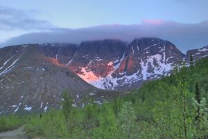
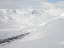 Khibins in winter | |
| أعلى نقطة | |
| القمة | Yudychvumchorr |
| الارتفاع | 1,201 m (3,940 ft) |
| الإحداثيات | 67°43′21″N 33°28′06″E / 67.72250°N 33.46833°E |
| الأبعاد | |
| المساحة | 1,300 km2 (500 sq mi) |
| الجغرافيا | |
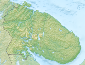
الموقع في أبلاست مورمانسك، روسيا | |
| البلد | Russia |
| المنطقة | Kola Peninsula |
| نطاق الإحداثيات | 67°44.1′N 33°43.6′E / 67.7350°N 33.7267°E |
جبال خيبيني (روسية: Хиби́ны [xʲɪˈbʲinɨ]؛ Kildin Sami: Umptek؛ إنگليزية: Khibiny Mountains)[1] is one of the two main mountain ranges of the Kola Peninsula, Russia, within the Arctic Circle, located between Imandra and Umbozero lakes. The range is also known as Khibiny Massif, Khibinsky Mountains, Khibinsky Tundras, Khibins or Khibiny. The Khibiny National Park was set up in 2018.
. . . . . . . . . . . . . . . . . . . . . . . . . . . . . . . . . . . . . . . . . . . . . . . . . . . . . . . . . . . . . . . . . . . . . . . . . . . . . . . . . . . . . . . . . . . . . . . . . . . . . . . . . . . . . . . . . . . . . . . . . . . . . . . . . . . . . . . . . . . . . . . . . . . . . . . . . . . . . . . . . . . . . . . .
الجغرافيا
The Khibiny Massif are the highest mountains of the Kola Peninsula, a large peninsula extending from northern Russia into the Barents and White seas. The total land area of the peninsula is approximately 100,000 square kilometres (39,000 sq mi). It is rich in minerals due to the removal of a layer of soil during the last ice age.[2]
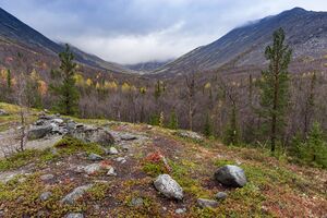
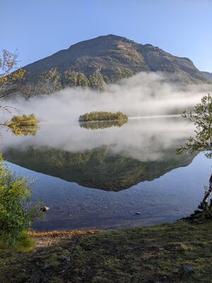
The Khibiny Massif is of oval shape of about 1,300 km2. and occupies the central part of the peninsula at a relative elevation of 900–1000 m above the surrounding plain. The mountains are not particularly high; the two highest peaks are the Yudychvumchorr, which stands 1,201 metres (3,940 ft), and the Chasnachorr, which stands 1,191 metres (3,907 ft).[3] The average elevation is 1,116 metres (3,661 ft).[4] The mountains form the shape of a horseshoe topped by a high plateau, drained by a series of deep canyons. The peaks are of plateau type, with steep slopes, with glaciers, icefields and snowfields in some places. The overall terrain is alpine tundra.
The second, and similar mountain range of the Kola Peninsula, the Lovozero Tundras, is located about 5 km east from the easternmost point of Khibiny, separated from it by Lake Umbozero.[2]
The Khibiny range is extremely rich in minerals, mainly apatite and nepheline ores. 477 valid minerals have been reported and 108 of those are type localities or minerals first described in the Khibiny.[5] The range is also seismically active.
Khibiny mountains are mostly uninhabited, except for one of the world's richest mineral quarries. One of the minerals discovered there is reported to have a potential as a nuclear waste radioactivity absorbent.[6] By the foot of the massif the cities of Apatity and Kirovsk are situated.
المناخ
Khibiny have an Arctic-moderate climate, with an average winter temperature of −5 °C (23 °F). However, the temperature can potentially drop to −30 °C (−22 °F) during the night. The Gulf Stream, which brings warmer water to the Kolsky Peninsula from the north, moderates the climate, making it slightly warmer than other Arctic regions.[3]
أسماء أماكن في الخيبين
- Mount Aikuaiventchorr
- Mount Eveslogchorr
- Hackman Valley
- Kaskasnyunchorr
- Khibinpakhchorr
- Mount Koashkar
- Mount Koashva
- Kuniok Valley
- Mount Maly Mannepakhk
- Mount Kukisvumchorr
- Marchenko Peak
- Mount Rasvumchorr
- Mount Restin'yun
- Mount Yukspor
- Loparskaya Valley
- Mount Nyorkpakhk (Niorkpakhk, N'orkpukhk, N'Yourpakhk)
- Mount Partomchorr
- Petrelius River
- Mount Rischorr
- Mount Takhtarvumchorr
- Tuliylukht Bay
- Vuonnemiok River
- Imandra Lake
- Yum'egor Pass
- Mount Vud'yavrchorr (with botanical garden of polar-alpine flora)
التعدين
On the territory of the Khibiny massif there are the largest deposits of apatite-nepheline ores.
At present, the following mines are operating: Kirovsky (Kukisvumchorr and Yukspor deposits), Rasvumchorr (Apatite Circus and Rasvumchorr plateau deposits), Vostochny (Koashva and Njorkpahk deposits) and recently discovered - Deer Creek (Koashva deposit). Mining is carried out both underground and open-pit methods. The number of open-pit mining operations is decreasing and soon the development of deposits will be carried out only by the underground method.
The main minerals mined in the Khibiny are: apatite, nepheline, sphene, aegirin, feldspar, titanomagnetite. Previously, lovchorrite was mined. The massif contains in its depths the largest reserves of zirconium raw materials (zircon, eudialyte) and its accompanying hafnium (zircon), which are not currently being mined. At the same time, a significant amount of this raw material is currently stored in the tailings dumps of the apatite-nepheline factory.
المراجع
- ^ Ферсман А. Е. (1960). Путешествия за камнем. М.: Издательство Академии наук СССР.
- ^ أ ب "Mineral Number 27-4". Archived from the original on 2008-04-03. Retrieved 2009-02-16.
- ^ أ ب "Khibinsky Mountains". Retrieved 2009-02-16.
- ^ "The Khibiny (Khibinsky tundras)". Archived from the original on 2007-09-28. Retrieved 2009-02-16.
- ^ http://www.mindat.org/loc-2680.html Khibiny Massif, Kola Peninsula, Murmanskaja Oblast', Northern Region, Russia, Mindat.org
- ^ "Safe Nuclear Dump discovered- April 24, 2008". Retrieved 2009-02-16.
وصلات خارجية
 Media related to Khibiny Massif at Wikimedia Commons
- Guide to the Khibiny
- hibiny.info Archived 2017-08-13 at the Wayback Machine (in روسية)
- Khibiny geology and minerals
- Pages using gadget WikiMiniAtlas
- Coordinates on Wikidata
- Articles containing روسية-language text
- Pages using Lang-xx templates
- Articles containing Kildin Sami-language text
- Articles containing إنگليزية-language text
- Articles with hatnote templates targeting a nonexistent page
- Articles with روسية-language sources (ru)
- Mountain ranges of Russia
- جبال أبلاست مورمانسك
