ساريآركا
| Kazakh Uplands | |
|---|---|
| Сарыарқа / Казахский мелкосопочник | |
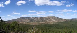
 Landscape of the Karkaraly Range, one of the ranges of the uplands | |
| أعلى نقطة | |
| القمة | Aksoran |
| الارتفاع | 1,565 m (5,135 ft) |
| الإحداثيات | 48°25′26″N 75°28′16″E / 48.42389°N 75.47111°E |
| الأبعاد | |
| الطول | 1,200 km (750 mi) E / W |
| العرض | 400 km (250 mi) N/ S |
| الجغرافيا | |
Location in Kazakhstan | |
| الموقع | Kazakhstan |
| نطاق الإحداثيات | 50°26′N 69°11′E / 50.433°N 69.183°E |
| الجيولوجيا | |
| التجبل | Alpine orogeny |
| عمر الصخر | Paleozoic, Cenozoic |
| نوع الصخر | Granite, limestone, schist, quartzite, sandstone |
| Kazakh Uplands | |
|---|---|
| علم البيئة | |
| النطاق | Palearctic |
| حيوم | Temperate grasslands, savannas, and shrublands |
| الجغرافيا | |
| المساحة | 72,000 km2 (28,000 sq mi) |
| البلد | قزخستان |
ساريآركا أو المرتفعات القزخية (Kazakh Uplands ؛ بالقزخية: Сарыарқа، ساريآركا - "النتوء الأصفر"، روسية: Казахский мелкосопочник, Kazakhskiy Melkosopochnik), also known as the Kazakh Hummocks, is a large peneplain formation extending throughout the central and eastern regions of Kazakhstan.[1]
Administratively the Kazakh Uplands stretch across the East Kazakhstan, Pavlodar, Akmola, Ulytau and Karaganda regions. Several notable cities, including the country's capital, Nur-Sultan, are located in the uplands. There are large deposits of coal in the north and copper in the south.
الجغرافيا
The Kazakh Uplands are limited by the West Siberian Plain to the north, the Irtysh valley to the northeast, the Turan Lowland to the southwest and by the Turgay Depression to the west.[2]
The uplands include mountain ranges of moderate altitude, such as the Karkaraly, Kokshetau —with Mount Kokshe, Kyzylarai, Bayanaul, Kyzyltas, Ulutau, Degelen, Aksoran and Chingiztau, as well as elevated plains. Rivers such as the Ishim, Sileti, Sarysu, Nura and the Uly-Zhylanshyk have their sources in the uplands. Lake Tengiz lies in an intermontane basin of the uplands and is the largest of the area.[3]
البيئة
Parts of the Kazakh Uplands are included in the Saryarka – Steppe and Lakes of Northern Kazakhstan World Heritage Site. It belongs to the Palearctic temperate grasslands, savannas, and shrublands ecoregion of the temperate grasslands, savannas, and shrublands biome.[4] The Karkaraly National Park, Kokshetau National Park, Burabay National Park and Bayanaul National Park are protected areas in the ranges of the upland. Rare species, such as the Asiatic cheetah, may still live in the region.
انظر أيضاً
المراجع
- ^ Казахский мелкосопочник (Kazakh Uplands) Great Soviet Encyclopedia in 30 vols. — Ch. ed. A.M. Prokhorov. - 3rd ed. - M. Soviet Encyclopedia, 1969-1978. (in Russian)
- ^ Google Earth
- ^ Селеты; Great Soviet Encyclopedia in 30 vols. — Ch. ed. A.M. Prokhorov. - 3rd ed. - M. Soviet Encyclopedia, 1969-1978. (in Russian)
- ^ قالب:WWF ecoregion
وصلات خارجية
 Media related to ساريآركا at Wikimedia Commons
- Kazakh Uplands Encyclopædia Britannica
- Kazakh Uplands on "Nomadic Travel Kazakhstan" web-site
