نهر حمزة
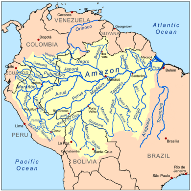
نهر حمزة هو الأخ الشقيق لنهر الأمازون أعجوبة قارة أميريكا الجنوبية .,هو بنفس الطول ولكنه يجرى تحت الأرض. ومن المعروف أن نهر الأمازون هو أطول ثانى نهر في العالم ، فهو أقصر من نهر النيل، ولكن للعجب ، فقد اكتشف العلماء نهر آخر يتدفق آلاف الأقدام تحته.
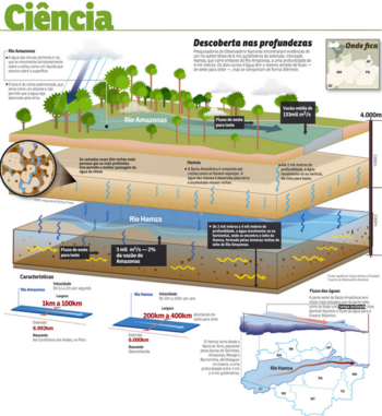
الباحثون من المرصد الوطني للبرازيل يعتقدون أن النهر طوله 3700 كيلومتر تحت الارض ، وهو نفس طول نهر الأمازون على السطح.
الوصف
الدكتور حمزة واليا، من مرصد البرازيل الوطني (BNO)، قال إن إكتشاف النهر الجوفي جاء في عقاب دراسة التغيرات في درجة حرارة في 241 من آبار النفط نشط التى تم حفرها في 1970 و 1980 من قبل شركة النفط البرازيلية التي تديرها الدولة وشركة بتروبراس. وقال ان "المعلومات الحرارية" التي تقدمها شركة بتروبراس سمحت لفريقه من الباحثين لتحديد حركة المياه تحت 13100 قدم نهر الأمازون.
وقدمت نتائجها الأسبوع الماضي في ريو دي جانيرو في اجتماع للجمعية الجيوفيزيائية البرازيلية. العثور على المحاكاة الحاسوبية التي قدمهتا طالبة الدكتوراه اليزابيث بيمنتل، التى تتمثل في أن تدفق المياه الجوفية كان بشكل عمودي في معظمها إلى حوالي عمق 6500 قدم ولكن تغير الاتجاه أفقيا تقريبا، وذلك أكبر في الأعماق العظمى.
وقد سمي النهر الواضح تحت الارض بعد مكتشفه حمزة، و يعد تكريما للعالم الذي كان رئيس فريق البحث الذى كشف عن علامات المياه المتدفقة.
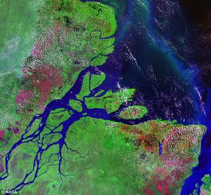
ويعتقد أن تبدأ في منطقة عكا التدفق من خلال أحواض Solimoes، والأمازون ماراجو وتصل إلى البحر في فوز دو الأمازون. وهذا يفسر لماذا جيوب واسعة من البحر في هذه المنطقة ذات الملوحة المنخفضة.
التدفق المتوسط لنهر حمزة المكتشف حديثا هو مجرد اثنين في المائة من نهر الأمازون، ولكن هذا يضعه على قدم المساواة مع نهر سان فرانسيسكو في كاليفورنيا.
ويقدر متوسط التدفق في نهر الأمازون بحوالي 133،000 مترا مكعبا / ثانية ، في حين تدفق نهر حمزة أبطأ بكثير حيث قدر ب 3090 مترا مكعبا / ثانية.
وقال الدكتور حمزة أن وجود الأنهار الجوفية التي تتدفق من الغرب إلى الشرق ستعني أيضا أن غابات الامازون المطيرة لها نظامين إثنين للصرف -- الأمازون ونهر حمزة. وشدد على أن الدراسات التي تبحث في الأنهار تحت الارض لا تزال في مراحلها الأولية لكنه اضاف انه يتوقع ان تؤكد تدفق المياه الجوفية بحلول نهاية عام 2014.
إلا أنه رفض التعليق على الآثار الاقتصادية والبيئية لنهر تحت الارض في غابات الامازون المطيرة.
الجيولوجيا
Several geological factors have played a vital role in the formation and existence of these subterranean water bodies. The porous and permeable sedimentary rocks behave as conduits for the water to sink to greater depths. East–west trending faults and the karst topography present along the northern border of the Amazon basin may have some role in supplying water to the "river". If the impermeable rocks stop the vertical flow, the west-to-east gradient of the topography directs it to flow towards the Atlantic Ocean.[بحاجة لمصدر]
Unlike the Hamza, the 153 km-long underground river in Mexico's Yucatán Peninsula[1] and the 8.2 km-long Cabayugan River in the Puerto Princesa Subterranean River National Park in the Philippines have come into being thanks to the karst topography. Water in these places has dissolved the carbonate rock to form extensive underground river systems.
الوضع البحثي والجدل
The Hamza was discovered by a team of scientists led by Valiya Hamza[2] using thermal data collected from 241 inactive oil wells in the area, drilled in the 1970s and 1980s, by the Petrobras oil company.[3] Calculations from the data showed that a larger flow should exist. Direct observation of water movement at a very low rate can be difficult.[4] The speed of flow is slower than that of an average glacier, and Hamza himself says that the team uses the term "river" in a general sense, not in the conventional sense. In the title to the original paper, the word "river" appears in quotation marks.
The evidence was presented at the 12th International Congress of the Brazilian Geophysical Society in Rio de Janeiro and as of August 2011 has not yet been published, although the research team noted that the techniques used to predict the flowing aquifer's presence are not unusual for earth science.[4] Scientists have explained that the research results are preliminary, and that the definite scientific validation of the existence of the flowing aquifer is to be expected in a few years.[2]
انظر أيضاً
وصلات خارجية
الهامش
- ^ "World's Longest Underground River Discovered in Mexico". news.nationalgeographic.com. Archived from the original on March 11, 2007. Retrieved 2017-01-24.
- ^ أ ب "Brazilian scientists find signs of 3,700-mile (or about 5,800 kilometer)-long underground river flowing far under Amazon River". The Washington Post. August 27, 2011. Archived from the original on September 6, 2011. Retrieved 2011-08-25.
- ^ Lehman, Stan (August 27, 2011). "Brazil scientists find signs of underground river". Sacramento Bee. Retrieved 2011-08-25.[dead link]
- ^ أ ب Black, Richard (August 27, 2011). "Subterranean Amazon river 'is not a river'". UK: BBC. Retrieved 2011-08-27.


