مقاطعة بوير أحمد
Boyer-Ahmad County
فارسية: شهرستان بویراحمد | |
|---|---|
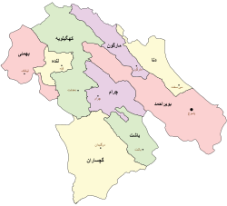
 موقع مقاطعة بوير أحمد في محافظة کهگيلويه وبوير أحمد (يمين، وردي) | |
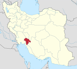
 Location of Kohgiluyeh and Boyer-Ahmad province in Iran | |
| الإحداثيات: 30°45′34″N 51°14′19″E / 30.75944°N 51.23861°E[1] | |
| البلد | إيران |
| المحافظة | کهگيلويه وبوير أحمد |
| Capital | ياسوج |
| Districts | Central، Kabgian، Ludab، Sepidar |
| التعداد (2016)[2] | |
| • الإجمالي | 299٬885 |
| منطقة التوقيت | UTC+3:30 (IRST) |
| مقاطعة بوير أحمد can be found at GEOnet Names Server, at this link, by opening the Advanced Search box, entering "9206905" in the "Unique Feature Id" form, and clicking on "Search Database". | |
مقاطعة بوير أحمد (فارسية: شهرستان بویراحمد) تقع في محافظة کهگيلويه وبوير أحمد، في جنوب غرب إيران. وعاصمتها هي مدينة ياسوج.[3]
التاريخ
After the 2011 National Census, Kabgian District was separated from Dana County to join Boyer-Ahmad County.[4]
After the 2016 census, the city of Madavan[أ] was merged with the city of Yasuj.[6] Sepidar Rural District was separated from the Central District in the establishment of Sepidar District, which was divided into two rural districts, including the new Sivaki Rural District;[7] and the village of Sepidar was elevated to the status of a city.[8]
In 2019, Margown District was separated from the county in the establishment of Margown County, which was divided into two districts of two rural districts each, with Margown as its capital and only city.[9]
السكان
التعداد
At the time of the 2006 census, the county's population was 212,552 in 43,490 households.[10] The following census in 2011 counted 243,771 people in 58,281 households.[11] The 2016 census measured the population of the county as 299,885 in 77,569 households.[2]
التقسيمات الإدارية
Boyer-Ahmad County's population history and administrative structure over three consecutive censuses are shown in the following table.
| بخش | مرکز بخش | جمعیت بخش (۱۳۹۵) |
دهستان | مرکز دهستان | جمعیت دهستان (۱۳۹۵) |
شهر | جمعیت شهر (۱۳۹۵) |
|---|---|---|---|---|---|---|---|
| مرکزی | یاسوج | ۲۶۰٬۸۴۰ | سررود جنوبی | علیآباد سرتل | ۵۳٬۷۲۶ | یاسوج | ۱۹۴٬۵۳۵ |
| سررود شمالی | گوشه شاهزاده قاسم | ۳۴٬۱۴۰ نفر | |||||
| کاکان | منصورخانی | ۱٬۷۰۸ نفر | |||||
| دشت روم | حسینآباد علیا | ۱۰٬۸۵۳ نفر | |||||
| لوداب | گراب سفلی | ۱۱٬۲۹۵ | لوداب | گراب سفلی | ۷٬۰۸۳ | گراب سفلی | ۵۴۵ |
| چین | ... | ۳٬۶۶۷ | |||||
| سپیدار | سپیدار | ۷٬۸۰۳ | سپیدار | پازنان | ۳٬۶۱۱ | سپیدار |
۱٬۵۰۳ |
| سیوکی | سیوکی جلیل | ۲٬۶۸۹ | |||||
| کبگیان | چیتاب | ۷٬۷۴۱ | کبگیان | چیتاب | ۴٬۸۱۱ | چیتاب |
۱٬۱۶۴ |
| چنار | دم چنار | ۱٬۷۶۱ |
انظر أيضاً
 وسائط متعلقة بـمقاطعة بوير أحمد من مشاع المعرفة.
الهامش
المراجع
- ^ OpenStreetMap contributors (25 May 2024). "Boyer-Ahmad County" (Map). OpenStreetMap (in الفارسية). Retrieved 25 May 2024.
- ^ أ ب "Census of the Islamic Republic of Iran, 1395 (2016)". AMAR (in الفارسية). The Statistical Center of Iran. p. 17. Archived from the original (Excel) on 2 November 2021. Retrieved 19 December 2022.
- ^ Habibi, Hassan (21 June 1369). "Approval of the organization and chain of citizenship of the units of the national divisions of Kohgiluyeh and Boyer-Ahmad province, centered in the city of Yasuj". Lamtakam (in الفارسية). Ministry of Interior, Defense Political Commission of the Government Council. Archived from the original on 24 January 2024. Retrieved 24 January 2024.
- ^ Rahimi, Mohammadreza (20 May 2013). "Approval letter regarding the annexation of Kabgian District with its center of the city of Chitab from Dana County to Boyer-Ahmad County". Islamic Council Research Center (in الفارسية). Ministry of Interior, Council of Ministers. Archived from the original on 24 June 2021. Retrieved 12 August 2023.
- ^ Davodi, Parviz (29 July 2016). "The transformation of Madavan-e Olya village from Sarrud-e Shomali Rural District in the Central District of Boyer-Ahmad County in Kohgiluyeh and Boyer-Ahmad province to Madavan city". Qavanin (in الفارسية). Ministry of Interior, Political-Defense Commission of the Government Board. Archived from the original on 12 August 2023. Retrieved 12 August 2023.
- ^ "The annexation of several villages to the city of Yasuj". Mehr News (in الفارسية). Ministry of Interior, Board of Ministers. 10 May 2023. Archived from the original on 12 August 2023. Retrieved 12 August 2023.
- ^ Jahangiri, Ishaq (8 October 2018). "Letter of approval regarding the country divisions of Boyer-Ahmad County in Kohgiluyeh and Boyer-Ahmad province". Qavanin (in الفارسية). Ministry of Interior, Council of Ministers. Archived from the original on 12 August 2023. Retrieved 12 August 2023.
- ^ "The approval of the Ministry of Interior to upgrade the village of Sepidar, Boyer-Ahmad County, to a city". Mehr News (in الفارسية). Ministry of Interior. 5 July 1400. Archived from the original on 12 August 2023. Retrieved 12 August 2023.
- ^ Jahangiri, Ishaq (8 October 2018). "Divisional changes and reforms in Kohgiluyeh and Boyer-Ahmad province". Qavanin (in الفارسية). Ministry of Interior, Council of Ministers. Archived from the original on 11 August 2023. Retrieved 11 August 2023.
- ^ "Census of the Islamic Republic of Iran, 1385 (2006)". AMAR (in الفارسية). The Statistical Center of Iran. p. 17. Archived from the original (Excel) on 20 September 2011. Retrieved 25 September 2022.
- ^ "Census of the Islamic Republic of Iran, 1390 (2011)". Syracuse University (in الفارسية). The Statistical Center of Iran. p. 17. Archived from the original (Excel) on 19 January 2023. Retrieved 19 December 2022.
