بروجن
بروجن
فارسية: بروجن Borujen ، Borojen | |
|---|---|
مدينة | |
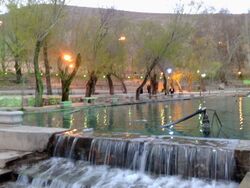
 موقع سياسرد السياحي عند الغروب في الصيف | |
| الإحداثيات: 31°58′04″N 51°17′22″E / 31.96778°N 51.28944°E[1] | |
| البلد | |
| المحافظة | چهارمحال وبختیاری |
| المقاطعة | بروجن |
| بخش | مركزي |
| الحكومة | |
| • العمدة | گرشاسب ريگي |
| المنسوب | 2٬197 m (7٬208 ft) |
| التعداد (2016)[3] | |
| • الإجمالي | 57٬071 |
| منطقة التوقيت | UTC+3:30 (IRST) |
| مفتاح الهاتف | 382 |
بروجن (فارسية: بروجن، Boroujen ، وتـُعرف أيضاً بإسم أورجن)[4] هي مدينة في البخش المركزي في مقاطعة بروجن، بمحافظة چهارمحال وبختیاری، إيران، وهي عاصمة المقاطعة.[5] سكان المدينة هم من الفرس مع أقلية من اللر والشعوب التوركية.[6][7]
At the 2006 census, its population was 49,077 in 12,828 households.[8] The following census in 2011 counted 52,694 people in 14,858 households.[9] The latest census in 2016 showed a population of 57,071 people in 17,228 households.[3]
. . . . . . . . . . . . . . . . . . . . . . . . . . . . . . . . . . . . . . . . . . . . . . . . . . . . . . . . . . . . . . . . . . . . . . . . . . . . . . . . . . . . . . . . . . . . . . . . . . . . . . . . . . . . . . . . . . . . . . . . . . . . . . . . . . . . . . . . . . . . . . . . . . . . . . . . . . . . . . . . . . . . . . . .
الطقس والمناخ
Borujen is well known for its extremely cold weather, usually mentioned as one of the coldest Iranian cities in national weather forecasts. It is located on an altitude of about 2197 m above sea level. Its climate is usually a combination of moderate summers and very cold winters. Snow days are normally 122 days per year, and the temperature could reach -27 °C. The maximum observed temperature has been 36 °C. Average annular precipitation is 243 مم (24% in the spring, 1% في الصيف، 33% في الخريف، و 44% في الشتاء).
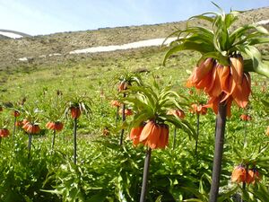
بروجن هي واحدة من أعلى المدن منسوباً في إيران، مما يجعلها ثرية بالفواكه والنبيت والوحيش.[البحث الأصلي؟] تقع المدينة في وادي بنفس الاسم، وتبلغ مساحته 580 كم² في الجزء الشرقي من محافظة چهارمحال وبختیاری.
| Climate data for بروجن (1988-2005، ارتفاع=2197م) | |||||||||||||
|---|---|---|---|---|---|---|---|---|---|---|---|---|---|
| Month | Jan | Feb | Mar | Apr | May | Jun | Jul | Aug | Sep | Oct | Nov | Dec | Year |
| Mean daily maximum °C (°F) | 3.8 (38.8) |
6.4 (43.5) |
11.0 (51.8) |
17.1 (62.8) |
22.7 (72.9) |
28.7 (83.7) |
31.5 (88.7) |
31.0 (87.8) |
27.2 (81.0) |
20.7 (69.3) |
13.4 (56.1) |
8.0 (46.4) |
18.5 (65.2) |
| Daily mean °C (°F) | −1.9 (28.6) |
0.6 (33.1) |
4.8 (40.6) |
10.2 (50.4) |
14.6 (58.3) |
19.1 (66.4) |
22.2 (72.0) |
21.3 (70.3) |
17.3 (63.1) |
11.9 (53.4) |
6.2 (43.2) |
1.9 (35.4) |
10.7 (51.2) |
| Mean daily minimum °C (°F) | −7.7 (18.1) |
−5.2 (22.6) |
−1.4 (29.5) |
3.3 (37.9) |
6.5 (43.7) |
9.5 (49.1) |
13.0 (55.4) |
11.6 (52.9) |
7.4 (45.3) |
3.0 (37.4) |
−0.9 (30.4) |
−4.2 (24.4) |
2.9 (37.2) |
| Average precipitation mm (inches) | 45.3 (1.78) |
33.6 (1.32) |
54.1 (2.13) |
27.4 (1.08) |
8.9 (0.35) |
1.2 (0.05) |
0.8 (0.03) |
0.1 (0.00) |
0.2 (0.01) |
5.2 (0.20) |
23.7 (0.93) |
53.7 (2.11) |
254.2 (9.99) |
| Average relative humidity (%) | 60 | 53 | 47 | 40 | 33 | 24 | 24 | 23 | 24 | 34 | 45 | 54 | 38 |
| Average dew point °C (°F) | −9.0 (15.8) |
−8.4 (16.9) |
−6.2 (20.8) |
−2.9 (26.8) |
−0.9 (30.4) |
−0.8 (30.6) |
2.3 (36.1) |
0.8 (33.4) |
−2.2 (28.0) |
−3.2 (26.2) |
−5.1 (22.8) |
−7.0 (19.4) |
−3.5 (25.6) |
| Mean monthly sunshine hours | 215.0 | 226.8 | 242.8 | 256.4 | 333.4 | 359.8 | 342.3 | 341.5 | 319.2 | 293.6 | 230.0 | 219.4 | 3٬380٫2 |
| Source: IRIMO [10] | |||||||||||||
معرض صور
التعليم العالي
Borujen hosts several higher education institutes:
- Payam-e-Noor University of Boroujen (in فارسية)
- Islamic Azad University of Boroujen (in فارسية)
- كلية بروجن للتمريض (in فارسية)
- مدرسة بروجن التقنية (in فارسية)
المراجع
- ^ OpenStreetMap contributors (1 April 2023). "Borujen, Borujen County" (Map). OpenStreetMap. Retrieved 1 April 2023.
- ^ "ايستگاه ها - اداره کل هواشناسي استان چهارمحال و بختياري". Archived from the original on 2004-10-19.
- ^ أ ب "Census of the Islamic Republic of Iran, 1395 (2016)". AMAR (in الفارسية). The Statistical Center of Iran. p. 14. Archived from the original (Excel) on 24 May 2019. Retrieved 19 December 2022.
- ^ بروجن can be found at GEOnet Names Server, at this link, by opening the Advanced Search box, entering "-3056915" in the "Unique Feature Id" form, and clicking on "Search Database".
- ^ Habibi, Hassan (21 June 1369). "Approval of the organization and chain of citizenship of the elements and units of the national divisions of Chaharmahal and Bakhtiari province, centered in the city of Shahrekord". Islamic Parliament Research Center (in الفارسية). Ministry of Interior, Defense Political Commission of the Government Board. Archived from the original on 21 September 2016. Retrieved 2 December 2023.
- ^ "Language distribution: Chahar Mahal va Bakhtiari Province". Iran Atlas. Archived from the original on 2017-12-04. Retrieved 25 March 2021.
- ^ Anonby, Erik. "Atlas of the Languages of Iran: A working classification". Iran Atlas. Archived from the original on 2019-12-29. Retrieved 27 March 2021.
- ^ "Census of the Islamic Republic of Iran, 1385 (2006)". AMAR (in الفارسية). The Statistical Center of Iran. p. 14. Archived from the original (Excel) on 20 September 2011. Retrieved 25 September 2022.
- ^ "Census of the Islamic Republic of Iran, 1390 (2011)". Syracuse University (in الفارسية). The Statistical Center of Iran. p. 14. Archived from the original (Excel) on 16 January 2023. Retrieved 19 December 2022.
- ^ Archived فبراير 17, 2016 at the Wayback Machine
وصلات خارجية
- Municipal Borujen
- Governor Borujen
- Borujen News Agency
- https://web.archive.org/web/20110712025929/http://broujencity.ir
- Pages using gadget WikiMiniAtlas
- CS1 الفارسية-language sources (fa)
- Short description is different from Wikidata
- Articles containing فارسية-language text
- Coordinates on Wikidata
- All articles that may contain original research
- Articles that may contain original research from September 2023
- Articles with فارسية-language sources (fa)
- Pages with empty portal template
- مقاطعة بروجن
- مدن محافظة چهارمحال وبختیاری
- أماكن مأهولة في مقاطعة بروجن


