ملف:Zealandia topography.jpg

حجم هذه المعاينة: 516 × 600 بكسل. البعد الآخر: 1٬391 × 1٬617 بكسل.
الملف الأصلي (1٬391 × 1٬617 بكسل حجم الملف: 1٫34 ميجابايت، نوع MIME: image/jpeg)
وصف قصير
| ⧼wm-license-information-description⧽ |
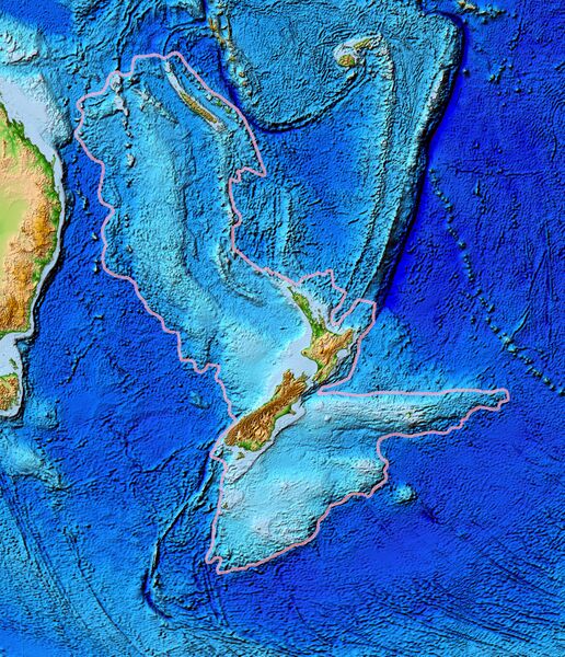
Topographical map of the Zealandia continent. |
| ⧼wm-license-information-date⧽ | 2006 |
| ⧼wm-license-information-source⧽ | Ultimate source: ETOPO2v2, a digital database of seafloor and land elevations. Actually cropped from Image:Pacific_elevation.jpg. |
| ⧼wm-license-information-author⧽ | World Data Center for Geophysics & Marine Geology (Boulder, CO), National Geophysical Data Center, NOAA |
| ⧼wm-license-information-permission⧽ (⧼wm-license-information-permission-reusing-text⧽) |
NOAA, public domain |
| ⧼wm-license-information-other-versions⧽ |
Image:Pacific_elevation.jpg, here cropped to focus on Zealandia. |
ترخيص

|
تاريخ الملف
اضغط على زمن/تاريخ لرؤية الملف كما بدا في هذا الزمن.
| زمن/تاريخ | صورة مصغرة | الأبعاد | مستخدم | تعليق | |
|---|---|---|---|---|---|
| حالي | ★ مراجعة معتمدة 11:42، 29 أكتوبر 2023 | | 1٬391 × 1٬617 (1٫34 ميجابايت) | Pastakhov (نقاش | مساهمات) | Upload https://upload.wikimedia.org/wikipedia/commons/7/7f/Zealandia_topography.jpg |
لا يمكنك استبدال هذا الملف.
وصلات
لا يوجد صفحات تصل لهذه الصورة.