ملف:Western sahara walls moroccan map-es.svg

حجم معاينة PNG لذلك الملف ذي الامتداد SVG: 772 × 600 بكسل. البعد الآخر: 2٬560 × 1٬989 بكسل.
الملف الأصلي (ملف SVG، أبعاده 1٬676 × 1٬302 بكسل، حجم الملف: 193 كيلوبايت)
وصف قصير
| ⧼wm-license-information-description⧽ | |
| ⧼wm-license-information-date⧽ | 2011-11-29 19:39 (UTC) |
| ⧼wm-license-information-source⧽ | |
| ⧼wm-license-information-author⧽ |
|
| ⧼wm-license-information-other-versions⧽ |
| [This is a retouched picture, which means that it has been digitally altered from its original version. Modifications: spanish. The original can be viewed here: Western_sahara_walls_moroccan_map-en.svg. Modifications made by Robot8A.] Error: {{Lang}}: text has italic markup (help)
|
ترخيص
|
قالب:Original upload log
This image is a derivative work of the following images:
- File:Western_sahara_walls_moroccan_map-en.svg licensed with Cc-by-sa-3.0
- 2011-08-19T17:00:33Z M0tty 1676x1302 (197156 Bytes) corr color legend
- 2011-08-17T09:01:54Z M0tty 1676x1302 (197399 Bytes) corr legend
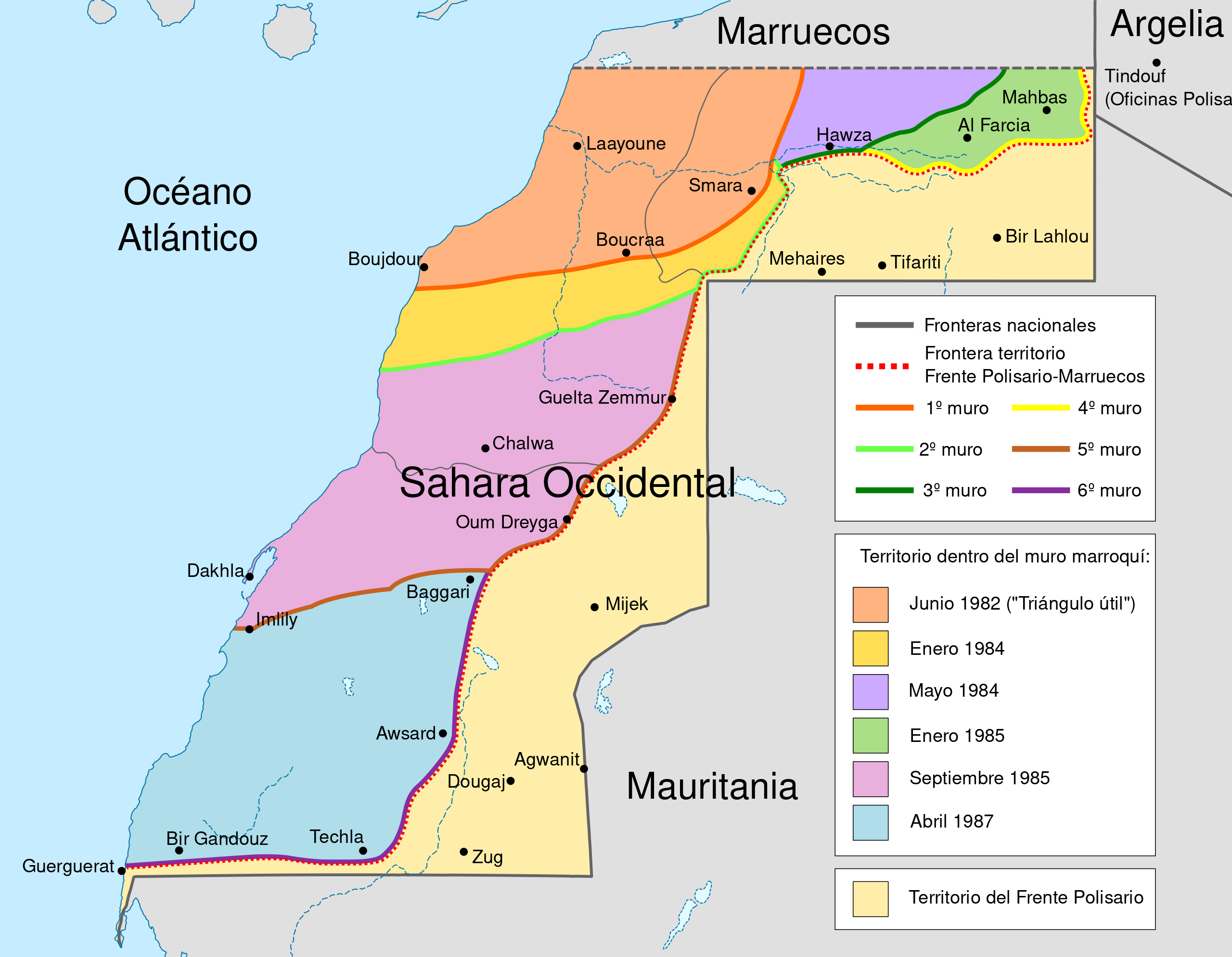
- 2011-08-16T18:46:57Z M0tty 1676x1302 (194768 Bytes) {{Information |Description={{en|Map of the [[w:Moroccan Wall]] in [[w:Western Sahara]] - built over several stages, shows the six walls built, & when the territory was behind Moroccan wall. Also shows polisaro held territory
تاريخ الملف
اضغط على زمن/تاريخ لرؤية الملف كما بدا في هذا الزمن.
| زمن/تاريخ | صورة مصغرة | الأبعاد | مستخدم | تعليق | |
|---|---|---|---|---|---|
| حالي | ★ مراجعة معتمدة 00:31، 25 أكتوبر 2023 | | 1٬676 × 1٬302 (193 كيلوبايت) | Pastakhov (نقاش | مساهمات) | Upload https://upload.wikimedia.org/wikipedia/commons/0/02/Western_sahara_walls_moroccan_map-es.svg |
لا يمكنك استبدال هذا الملف.
وصلات
لا يوجد صفحات تصل لهذه الصورة.