ملف:West-Ukraine 1918.jpg
الملف الأصلي (869 × 1٬250 بكسل حجم الملف: 433 كيلوبايت، نوع MIME: image/jpeg)

|
[All images in this gallery should be recreated using vector graphics as an SVG file. This has several advantages; see Commons:Media for cleanup for more information. If an SVG form of this image is already available, please upload it. After uploading an SVG, replace this template with {{vector version available|new image name.svg}}.] Error: {{Lang}}: text has italic markup (help) |
|
العربية | български | català | čeština | dansk | Deutsch | English | Esperanto | español | français | galego | 한국어 | italiano | magyar | lietuvių | 日本語 | Plattdüütsch | Nederlands | norsk | polski | português | română | русский | suomi | svenska | Türkçe | українська | 中文(繁體) | 中文(简体) | +/− | |
وصف قصير
| ⧼wm-license-information-description⧽ |
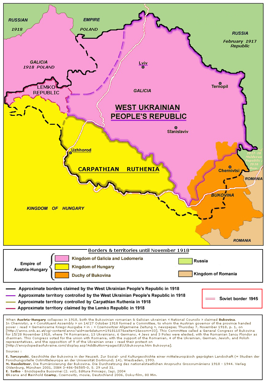
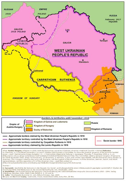
English: Map of the areas claimed and controlled by the Carpathian Ruthenia, the Lemko Republic and the West Ukrainian People's Republic in 1918
|
| ⧼wm-license-information-date⧽ | 2012 |
| ⧼wm-license-information-source⧽ | ⧼Wm-license-own-work⧽ - derivative work; modified version of this map: File:West_ukraine.png (author of that file was User:PANONIAN). |
| ⧼wm-license-information-author⧽ | Spiridon Ion Cepleanu |
When Austria-Hungary collapses in 1918, both the Bukovinian Romanian & Galician Ukrainian National Council claimed Bukovina. A Constituent Assembly on 14/27 October 1918 formed a Committee, to whom the Austrian governor of the province handed power. Read the Gemeinsame Kriegs-Ausgabe. Czernowitzer Allgemeine Zeitung / Tagblatt. Donnerstag, 7. November 1918, S. 1 on [1]. This Committee called a General Congress of Bukovina for 15/28 November 1918, where 74 Romanians, 13 Ukrainians, 6 Germans, 4 Jews and 3 Poles were elected, with the Romanian Iancu Flondor as chairman. This Congress voted for the union with Romania, with the support of the Romanian, a part of the Ukrainian, German, Jewish, and Polish representatives, and the protest of some Ukrainian ones (on Bukovyna and [2]).
![[2]](http://www.google.fr/imgres?imgurl=http://mapsatlas.com.ua/images/products/urfund_zunr.png&imgrefurl=http://mapsatlas.com.ua/en/product/products?projectid%3D10&h=500&w=705&tbnid=WRFqKxv7l1m-mM:&tbnh=90&tbnw=127&usg=__BBxqE4uNN1_rOinFMRxxbuBPk88=&docid=qXlAYLhGYHUwKM&sa=X&ved=0CDkQ9QEwA2oVChMI35jvrM34xgIVx1wUCh1YvQzV)
Since :
Scharr, K.: Historische Region Bukowina. Entstehen und Persistenz einer Kulturlandschaft. In: Thede Kahl, Michael Metzeltin, Mihai-Răzvan Ungureanu (ed.): Rumänien. Raum und Bevölkerung. Geschichte und Geschichtsbilder. Kultur. Gesellschaft und Politik heute. Wirtschaft. Recht und Verfassung. Historische Regionen (= Österreichische Osthefte; 48), Wien, Münster, 2006, pp. 839-856. ISBN 3-7000-0593-8.
Turczynski, E.: Geschichte der Bukowina in der Neuzeit. Zur Sozial- und Kulturgeschichte einer mitteleuropäisch geprägten Landschaft (= Studien der Forschungsstelle Ostmitteleuropa an der Universität Dortmund; 14, Wiesbaden, 1993).
Hausleitner, M.: Die Rumänisierung der Bukowina. Die Durchsetzung des nationalstaatlichen Anspruchs Grossrumäniens 1918 - 1944. Verlag Oldenbourg, München 2001, ISBN 3-486-56585-0, S. 29 und 31.
Satko, E.: Enciclopedia Bucovinei, ed. Princeps, Iasi, 2004.
Oksana Czarny und Reinhold Czarny, Czernowitz, einstige Kronstadt der K.K. Österreich-Ungarischen Monarchie, Deutschland 2006, Doku-film, 80 Min.
ترخيص
|
تاريخ الملف
اضغط على زمن/تاريخ لرؤية الملف كما بدا في هذا الزمن.
| زمن/تاريخ | صورة مصغرة | الأبعاد | مستخدم | تعليق | |
|---|---|---|---|---|---|
| حالي | ★ مراجعة معتمدة 08:40، 12 نوفمبر 2023 | | 869 × 1٬250 (433 كيلوبايت) | Pastakhov (نقاش | مساهمات) | Upload https://upload.wikimedia.org/wikipedia/commons/c/c6/West-Ukraine_1918.jpg |
لا يمكنك استبدال هذا الملف.
وصلات
لا يوجد صفحات تصل لهذه الصورة.
معلومات الصورة (ميتا)
- Other images that should use vector graphics
- Self-published work
- Maps of the history of modern Ukraine
- Maps of the history of Zakarpattia Oblast
- Maps of the Polish-Ukrainian War
- Maps of the Western Ukrainian People's Republic
- Maps of 20th-century Europe
- General Congress of Bukovina
- Maps of Western Ukraine
- Lemkivshchyna