ملف:Vatican City annex.jpg

الملف الأصلي(1٬024 × 818 بكسل حجم الملف: 318 كيلوبايت، نوع MIME: image/jpeg)

وصف قصير

⧼wm-license-information-description⧽
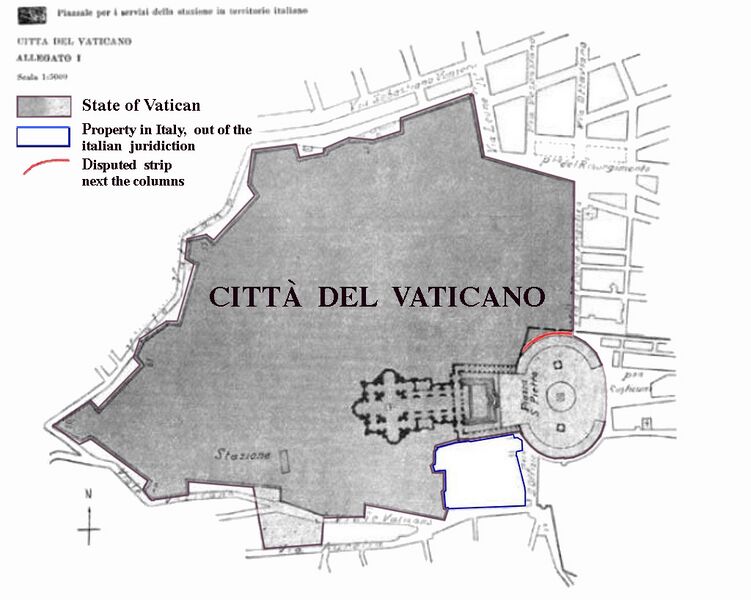
Deutsch: Karte der Vatikanstadt (aus dem Annex der Lateranverträge)
  • dunkelgrau: Territorium der Vatikanstadt
  • hellgrau (Petersplatz): Territorium der Vatikanstadt; Sicherheitsagenden an italienische Sicherheitskräfte delegiert (jederzeit widerrufbar).
  • rot: Der schmale Streifen (ca. 3 m breit und 60 m lang) entlang der Außenseite der rechten (d. h. nördlichen) Kolonnade Berninis ist nach den Lateranverträgen italienisches Territorium und unterliegt der italienischen Jurisdiktion. Diese Tatsache wurde von einer gemischten vatikanisch-italienischen Kommission, die bis 1932 tagte und welche die technischen Details der Verträge präzisierte, bestritten. Da diese Kommission jedoch von italienischen Seite nicht mit hochrangigen Juristen beschickt wurde und darüber hinaus nur beratende Funktion innehatte, wird die rechtliche Relevanz dieses Standpunktes von Italien nicht anerkannt.
  • blau umrandet: Das blauumrandete Gebiet ist zwar italienisches Territorium, steht jedoch im Besitz des Heiligen Stuhls und genießt exterritorialen Status (vergleichbar mit ausländischen Botschaften). Es untersteht nicht der italienischen Jurisdiktion.
  • Sonstiges: Das hellgraue Areal südlich des vatikanischen Bahnhofs (stazione) wurde laut Notiz links unten auf der Karte als "Fläche auf italienischem Territorium zur Versorgung des Bahnhofs" eingefärbt (dieser Bereich wurde in einer Karte der Gazetta Ufficiale von 1929 nicht hellgrau unterlegt). Möglicherweise wurde es dem Heiligen Stuhl aus dem genannten Grund als exterritoriale Besitzung auf italienischem Boden (eine Quelle weist es als solches aus) zur Verfügung gestellt.
English: Boundary map taken from the annex of the Lateran treaties. Colored areas are modifications of original image for purposes of clarification.
  • dark grey: territory of Vatican City.
  • light grey: territory of Vatican City. Security dispositive of Italy. Free access to public and to Italian police authorities may be revoked at any time for special ceremonial occasions.
  • red: The small strip (3 m wide, 60 m long) alongside the northern colonnade is - according to the Lateran treaties - Italian territory and underlies Italian jurisdiction. This fact has been disputed by the mixed Italian-Vatican commission which was in place until 1932 to refine and detail the findings of the treaties. Since this commission had only a consultatory status Italy does not recognize any legal relevance of this dispute.
  • blue zone: territory of Italy, but in possession of the Holy See. The area has extraterritorial status and Italian jurisdiction is not applied. The area contains the seat of the en:Congregation for the Doctrine of the Faith, the bigger part of the en:Paul VI Audience Hall, the Campo Santo Teutonico and the German College.
  • other: The light grey area next to the station has evidently been added in by mistake and is Italian territory.
Français :
  • gris foncé: territoire de plein-droit de l'état du Saint-Siège.
  • gris clair: territoire de l'état du Saint-Siège où s'appliquent les dispositifs de sécurité de l'Italie. Le libre accès du public et de la police italienne peut être suspendu à tout moment en cas de cérémonies et autres occasions spéciales. Ce statut est valide pour la Place Saint-Pierre mais non pour la zone située à la sortie du chemin de fer au niveau de la gare, qui n'a finalement pas été concédée à l'État du Vatican dans la version définitive du traité.
  • rouge: une bande de territoire large de 3m et longue de 60m le long des colonnes du nord est territoire italien selon le traité, mais jusqu'en 1932 ce fait est contesté par la partie vaticane dans la commission mixte italo-vaticane pour la délimitation. Cette commission n'a qu'un statut consultatif. L'Italie rejette toute contestation et ne reconnaît pas qu'il existerait une dispute. Toutefois de facto c'est l'État du Vatican qui administre ce territoire.
  • liséré bleu: territoire italien, propriété du Saint-Siège bénéficiant du statut d'exterritorialité. La juridiction italienne ne s'y applique pas. Ces bâtiments abritent la Congrégation pour la Doctrine de la Foi (ex-Inquisition), la plus grande partie de la salle d'audience du pape Paul VI et les bureaux de l'Ordre Teutonique.

قالب:Ro

⧼wm-license-information-date⧽ 1929
⧼wm-license-information-source⧽ Annex of the Lateran Treaty
⧼wm-license-information-author⧽ Original: de:Bild:Vatikanstadt_Annex.jpg, amended by gugganij

قالب:Ew

ترخيص

Public license
هذه الصورة هي ضمن الملكية عامة بسبب إنتهاء فترة صلاحية حقوقها في الولايات المتحدة الأمريكية و أي دولة أخرى ينص قانونها على مرور 70 سنة كحد أعلى على وفاة المنتج لإنتهاء صلاحية الحقوق.

قالب:Original upload log

قالب:Original description

  • 2010-05-16 01:43 Saibo 2283×2098× (1084697 bytes) gedreht (Einnordung) und Legendenelemente verschoben und Untertitel gelöscht
  • 2004-07-30 13:23 Gugganij 2104×2625× (219537 bytes) verkleinert (noch ein Versuch)
  • 2004-07-30 13:21 Gugganij 2104×2625× (219537 bytes) verkleinert
  • 2004-07-26 14:32 Gugganij 2104×2625× (219571 bytes) verkleinert
  • 2004-07-26 14:04 Gugganij 2104×2625× (262857 bytes) Karte der Vatikanstadt (aus dem [[Annex]] der [[Lateranverträge]]), [[Public domain]], bearbeitet von [[Benutzer:gugganij|gugganij]]

تاريخ الملف

اضغط على زمن/تاريخ لرؤية الملف كما بدا في هذا الزمن.

زمن/تاريخصورة مصغرةالأبعادمستخدمتعليق
حالي ★ مراجعة معتمدة
05:18، 7 نوفمبر 2023
تصغير للنسخة بتاريخ 05:18، 7 نوفمبر 20231٬024 × 818 (318 كيلوبايت)Pastakhov (نقاش | مساهمات)Upload https://upload.wikimedia.org/wikipedia/commons/b/bf/Vatican_City_annex.jpg

لا يوجد صفحات تصل لهذه الصورة.

معلومات الصورة (ميتا)