ملف:Tularosa-Basin-NM-USGS-map opaque.gif
حجم هذه المعاينة: 447 × 599 بكسل. البعد الآخر: 624 × 836 بكسل.
الملف الأصلي (624 × 836 بكسل حجم الملف: 59 كيلوبايت، نوع MIME: image/gif)
| ⧼wm-license-information-description⧽ |
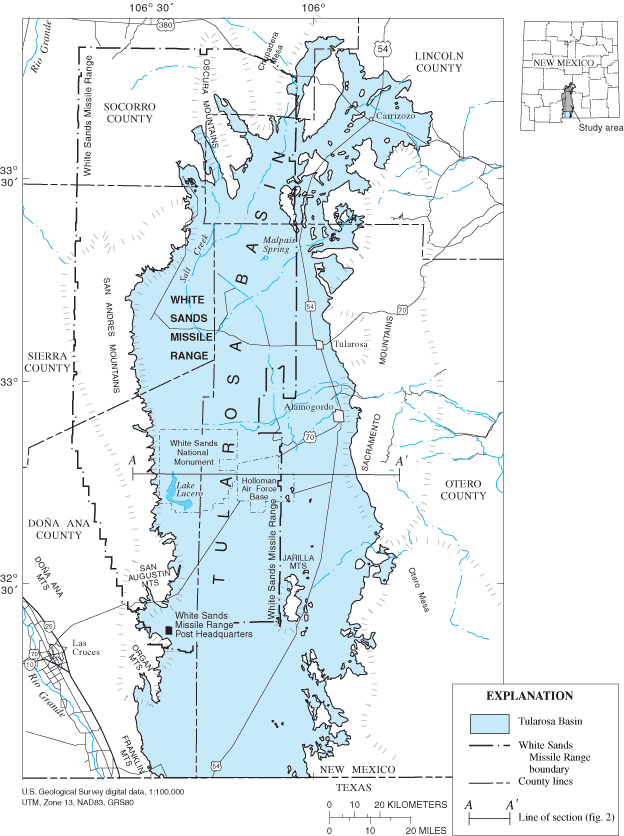
Location map of Tularosa Basin 2004. Huff, Glenn F. (2005) "Simulation of Ground-Water Flow in the Basin-Fill Aquifer of the Tularosa Basin, South-Central New Mexico, Predevelopment through 2040" Scientific Investigations Report 2004-5197, United States Geological Survey, Washongton, D.C., fig. 1. |
| ⧼wm-license-information-date⧽ | 2005 |
| ⧼wm-license-information-source⧽ | USGS (https://pubs.er.usgs.gov/usgspubs/sir/sir20045197) http://pubs.usgs.gov/sir/2004/5197/ http://pubs.usgs.gov/sir/2004/5197/images/fig1.gif |
| ⧼wm-license-information-author⧽ | Huff, Glenn F. (United States Geological Survey) |
| ⧼wm-license-information-permission⧽ (⧼wm-license-information-permission-reusing-text⧽) |
|
| ⧼wm-license-information-other-versions⧽ |
Image:Tularosa-Basin-NM-USGS-map.gif (transparent version) |
تاريخ الملف
اضغط على زمن/تاريخ لرؤية الملف كما بدا في هذا الزمن.
| زمن/تاريخ | صورة مصغرة | الأبعاد | مستخدم | تعليق | |
|---|---|---|---|---|---|
| حالي | ★ مراجعة معتمدة 20:55، 15 أكتوبر 2023 | | 624 × 836 (59 كيلوبايت) | Pastakhov (نقاش | مساهمات) | Upload https://upload.wikimedia.org/wikipedia/commons/d/d7/Tularosa-Basin-NM-USGS-map_opaque.gif |
لا يمكنك استبدال هذا الملف.
وصلات
لا يوجد صفحات تصل لهذه الصورة.