ملف:Treshnish Isles from above Port Haunn - geograph.org.uk - 270321.jpg
لا توجد دقة أعلى متوفرة.
Treshnish_Isles_from_above_Port_Haunn_-_geograph.org.uk_-_270321.jpg (640 × 333 بكسل حجم الملف: 50 كيلوبايت، نوع MIME: image/jpeg)
وصف قصير
| ⧼wm-license-information-description⧽ |
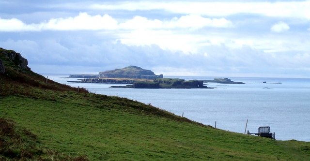
English: Treshnish Isles from above Port Haunn A supplementary photograph showing several of the Treshnish Isles lined up.
The nearest island is Cairn na Burgh Beg in front of, and slightly to the left of Cairn na Burgh Mor. Behind these lies the low flat island of Fladda. A whole gaggle of small islets (the westernmost of which looks remarkably like a submarine) are between Fladda and the tallest and largest Treshnish island Lunga. Lunga hides the remaining Treshnish Isles including Bac Mor or "Dutchman's Cap".
|
| ⧼wm-license-information-date⧽ | 2006 |
| ⧼wm-license-information-source⧽ | From geograph.org.uk |
| ⧼wm-license-information-author⧽ | Rob Farrow |
| ⧼wm-license-information-other-versions⧽ |
|
| ⧼wm-license-cc-attribution⧽ (قالب:I18n/Credit line) |
Rob Farrow / Treshnish Isles from above Port Haunn / |

56°32′42″N 6°20′06″W / 56.5451°N 6.335°W قالب:Object location
_heading:225)
ترخيص
تاريخ الملف
اضغط على زمن/تاريخ لرؤية الملف كما بدا في هذا الزمن.
| زمن/تاريخ | صورة مصغرة | الأبعاد | مستخدم | تعليق | |
|---|---|---|---|---|---|
| حالي | ★ مراجعة معتمدة 10:37، 14 أكتوبر 2023 | | 640 × 333 (50 كيلوبايت) | Pastakhov (نقاش | مساهمات) | Upload https://upload.wikimedia.org/wikipedia/commons/9/92/Treshnish_Isles_from_above_Port_Haunn_-_geograph.org.uk_-_270321.jpg |
لا يمكنك استبدال هذا الملف.
وصلات
الصفحات التالية تحتوي على وصلة لهذه الصورة: