ملف:The Round Building - geograph.org.uk - 1166550.jpg
لا توجد دقة أعلى متوفرة.
The_Round_Building_-_geograph.org.uk_-_1166550.jpg (640 × 480 بكسل حجم الملف: 111 كيلوبايت، نوع MIME: image/jpeg)
وصف قصير
| ⧼wm-license-information-description⧽ |
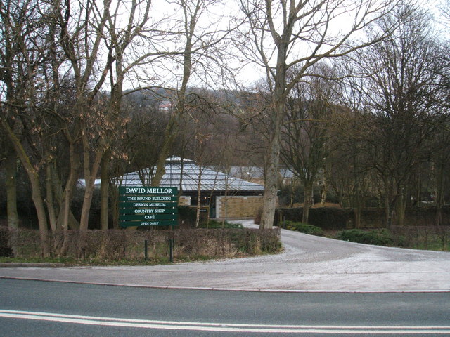
English: The Round Building "The David Mellor site was formerly the Hathersage village gasworks. The factory was built on the foundations of the old gas cylinder, hence the circular form. Built in local gritstone with spectacular lead roof, this highly functional building is set discreetly in a rural area of outstanding natural beauty." (Quote from David Mellor website)
|
| ⧼wm-license-information-date⧽ | 2009 |
| ⧼wm-license-information-source⧽ | From geograph.org.uk |
| ⧼wm-license-information-author⧽ | Peter Barr |
| ⧼wm-license-cc-attribution⧽ (قالب:I18n/Credit line) |
Peter Barr / The Round Building / |
53°19′25″N 1°39′06″W / 53.32348°N 1.6517°W قالب:Object location
_heading:45)
ترخيص
تاريخ الملف
اضغط على زمن/تاريخ لرؤية الملف كما بدا في هذا الزمن.
| زمن/تاريخ | صورة مصغرة | الأبعاد | مستخدم | تعليق | |
|---|---|---|---|---|---|
| حالي | ★ مراجعة معتمدة 22:24، 24 ديسمبر 2023 | | 640 × 480 (111 كيلوبايت) | Pastakhov (نقاش | مساهمات) | Upload https://upload.wikimedia.org/wikipedia/commons/8/8a/The_Round_Building_-_geograph.org.uk_-_1166550.jpg |
لا يمكنك استبدال هذا الملف.
وصلات
لا يوجد صفحات تصل لهذه الصورة.