ملف:Thames Ditton Island - geograph.org.uk - 1318632.jpg
لا توجد دقة أعلى متوفرة.
Thames_Ditton_Island_-_geograph.org.uk_-_1318632.jpg (640 × 427 بكسل حجم الملف: 75 كيلوبايت، نوع MIME: image/jpeg)
وصف قصير
| ⧼wm-license-information-description⧽ |
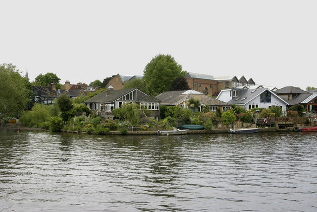
English: Thames Ditton Island Thames Ditton is the largest of the three islands that occupy this part of the Thames. It is connected to the mainland by the bridge which can be seen on the left of the picture.
|
| ⧼wm-license-information-date⧽ | 2009 |
| ⧼wm-license-information-source⧽ | From geograph.org.uk |
| ⧼wm-license-information-author⧽ | David Kemp |
| ⧼wm-license-cc-attribution⧽ (قالب:I18n/Credit line) |
David Kemp / Thames Ditton Island / |
51°23′41″N 0°19′48″W / 51.39486°N 0.3301°W قالب:Object location
_heading:247)
ترخيص
تاريخ الملف
اضغط على زمن/تاريخ لرؤية الملف كما بدا في هذا الزمن.
| زمن/تاريخ | صورة مصغرة | الأبعاد | مستخدم | تعليق | |
|---|---|---|---|---|---|
| حالي | ★ مراجعة معتمدة 16:14، 30 نوفمبر 2023 | | 640 × 427 (75 كيلوبايت) | Pastakhov (نقاش | مساهمات) | Upload https://upload.wikimedia.org/wikipedia/commons/a/ae/Thames_Ditton_Island_-_geograph.org.uk_-_1318632.jpg |
لا يمكنك استبدال هذا الملف.
وصلات
لا يوجد صفحات تصل لهذه الصورة.